Our topic for the weeks of April 4 and April 11 is dunes on Mars. We will look at the north polar sand sea and at isolated dune fields at lower latitudes. Sand seas on Earth are often called "ergs," an Arabic name for dune field. A sand sea differs from a dune field in two ways: 1) a sand sea has a large regional extent, and 2) the individual dunes are large in size and complex in form.
This VIS image was taken at 81 degrees North latitude during Northern spring. In this region, the dunes are isolated from each other. The dunes are just starting to emerge from the winter frost covering appearing dark with bright crests. These dunes are located on top of ice.
Image information: VIS instrument. Latitude 82.1, Longitude 191.3 East (168.7 West). 19 meter/pixel resolution.
Note: this THEMIS visual image has not been radiometrically nor geometrically calibrated for this preliminary release. An empirical correction has been performed to remove instrumental effects. A linear shift has been applied in the cross-track and down-track direction to approximate spacecraft and planetary motion. Fully calibrated and geometrically projected images will be released through the Planetary Data System in accordance with Project policies at a later time.
NASA's Jet Propulsion Laboratory manages the 2001 Mars Odyssey mission for NASA's Office of Space Science, Washington, D.C. The Thermal Emission Imaging System (THEMIS) was developed by Arizona State University, Tempe, in collaboration with Raytheon Santa Barbara Remote Sensing. The THEMIS investigation is led by Dr. Philip Christensen at Arizona State University. Lockheed Martin Astronautics, Denver, is the prime contractor for the Odyssey project, and developed and built the orbiter. Mission operations are conducted jointly from Lockheed Martin and from JPL, a division of the California Institute of Technology in Pasadena.
The theme for the weeks of 1/17 and 1/24 is the north polar region of Mars as seen in false color THEMIS images. Ice/frost will typically appear as bright blue in color; dust mantled ice will appear in tones of red/orange.
This image of shows a cross sectional view of the ice layers. Note the subtle peach banding on the left side of the image. The time variation that the bands represent is not yet understood.
Image information: VIS instrument. Latitude 83.5, Longitude 118.2 East (241.8 West). 19 meter/pixel resolution.
Note: this THEMIS visual image has not been radiometrically nor geometrically calibrated for this preliminary release. An empirical correction has been performed to remove instrumental effects. A linear shift has been applied in the cross-track and down-track direction to approximate spacecraft and planetary motion. Fully calibrated and geometrically projected images will be released through the Planetary Data System in accordance with Project policies at a later time.
NASA's Jet Propulsion Laboratory manages the 2001 Mars Odyssey mission for NASA's Office of Space Science, Washington, D.C. The Thermal Emission Imaging System (THEMIS) was developed by Arizona State University, Tempe, in collaboration with Raytheon Santa Barbara Remote Sensing. The THEMIS investigation is led by Dr. Philip Christensen at Arizona State University. Lockheed Martin Astronautics, Denver, is the prime contractor for the Odyssey project, and developed and built the orbiter. Mission operations are conducted jointly from Lockheed Martin and from JPL, a division of the California Institute of Technology in Pasadena.
Figure 1: Why There are Two Images of Odyssey
NASA's Mars Odyssey spacecraft appears twice in the same frame in this image from the Mars Orbiter Camera aboard NASA's Mars Global Surveyor. The camera's successful imaging of Odyssey and of the European Space Agency's Mars Express in April 2005 produced the first pictures of any spacecraft orbiting Mars taken by another spacecraft orbiting Mars.
Mars Global Surveyor and Mars Odyssey are both in nearly circular, near-polar orbits. Odyssey is in an orbit slightly higher than that of Global Surveyor in order to preclude the possibility of a collision. However, the two spacecraft occasionally come as close together as 15 kilometers (9 miles).
The images were obtained by the Mars Global Surveyor operations teamsat Lockheed Martin Space System, Denver; JPL and Malin Space ScienceSystems.
The two views of Mars Odyssey in this image were acquired a little under 7.5 seconds apart as Odyssey receded from a close flyby of Mars Global Surveyor. The geometry of the flyby (see Figure 1) and the camera's way of acquiring an image line-by-line resulted in the two views of Odyssey in the same frame. The first view (right) was taken when Odyssey was about 90 kilometers (56 miles) from Global Surveyor and moving more rapidly than Global Surveyor was rotating, as seen from Global Surveyor. A few seconds later, Odyssey was farther away -- about 135 kilometers (84 miles) -- and appeared to be moving more slowly. In this second view of Odyssey (left), the Mars Orbiter Camera's field-of-view overtook Odyssey.
The Mars Orbiter Camera can resolve features on the surface of Mars as small as a few meters or yards across from Mars Global Surveyor's orbital altitude of 350 to 405 kilometers (217 to 252 miles). From a distance of 100 kilometers (62 miles), the camera would be able to resolve features substantially smaller than 1 meter or yard across.
Mars Odyssey was launched on April 7, 2001, and reached Mars on Oct. 24, 2001. Mars Global Surveyor left Earth on Nov. 7, 1996, and arrived in Mars orbit on Sept. 12, 1997. Both orbiters are in an extended mission phase, both have relayed data from the Mars Exploration Rovers, and both are continuing to return exciting new results from Mars. JPL, a division of the California Institute of Technology, Pasadena, manages both missions for NASA's Science Mission Directorate, Washington, D.C.
Context image for PIA08441
Crater Slide
This landslide occurs in an unnamed crater.
Image information: VIS instrument. Latitude -7.4N, Longitude 76.8E. 18 meter/pixel resolution.
Please see the THEMIS Data Citation Note for details on crediting THEMIS images.
Note: this THEMIS visual image has not been radiometrically nor geometrically calibrated for this preliminary release. An empirical correction has been performed to remove instrumental effects. A linear shift has been applied in the cross-track and down-track direction to approximate spacecraft and planetary motion. Fully calibrated and geometrically projected images will be released through the Planetary Data System in accordance with Project policies at a later time.
NASA's Jet Propulsion Laboratory manages the 2001 Mars Odyssey mission for NASA's Office of Space Science, Washington, D.C. The Thermal Emission Imaging System (THEMIS) was developed by Arizona State University, Tempe, in collaboration with Raytheon Santa Barbara Remote Sensing. The THEMIS investigation is led by Dr. Philip Christensen at Arizona State University. Lockheed Martin Astronautics, Denver, is the prime contractor for the Odyssey project, and developed and built the orbiter. Mission operations are conducted jointly from Lockheed Martin and from JPL, a division of the California Institute of Technology in Pasadena.
The THEMIS VIS camera is capable of capturing color images of the Martian surface using five different color filters. In this mode of operation, the spatial resolution and coverage of the image must be reduced to accommodate the additional data volume produced from using multiple filters. To make a color image, three of the five filter images (each in grayscale) are selected. Each is contrast enhanced and then converted to a red, green, or blue intensity image. These three images are then combined to produce a full color, single image. Because the THEMIS color filters don't span the full range of colors seen by the human eye, a color THEMIS image does not represent true color. Also, because each single-filter image is contrast enhanced before inclusion in the three-color image, the apparent color variation of the scene is exaggerated. Nevertheless, the color variation that does appear is representative of some change in color, however subtle, in the actual scene. Note that the long edges of THEMIS color images typically contain color artifacts that do not represent surface variation.
This false color image shows a region with craters of different ages located at the margin of Acidalia Planitia. This iamge was collected during the Northern Spring season.
Image information: VIS instrument. Latitude 39.9, Longitude 350.4 East (9.6 West). 38 meter/pixel resolution.
Note: this THEMIS visual image has not been radiometrically nor geometrically calibrated for this preliminary release. An empirical correction has been performed to remove instrumental effects. A linear shift has been applied in the cross-track and down-track direction to approximate spacecraft and planetary motion. Fully calibrated and geometrically projected images will be released through the Planetary Data System in accordance with Project policies at a later time.
NASA's Jet Propulsion Laboratory manages the 2001 Mars Odyssey mission for NASA's Office of Space Science, Washington, D.C. The Thermal Emission Imaging System (THEMIS) was developed by Arizona State University, Tempe, in collaboration with Raytheon Santa Barbara Remote Sensing. The THEMIS investigation is led by Dr. Philip Christensen at Arizona State University. Lockheed Martin Astronautics, Denver, is the prime contractor for the Odyssey project, and developed and built the orbiter. Mission operations are conducted jointly from Lockheed Martin and from JPL, a division of the California Institute of Technology in Pasadena.
Welcome to the second annual THEMIS ART MONTH. From Jan. 31 through March 4 we will be showcasing images for their aesthetic value, rather than their science content. Portions of these images resemble things in our everyday lives, from animals to letters of the alphabet. We hope you enjoy our fanciful look at Mars!
Today we have a spectral vision that seems doomed to haunt Mars for eternity, or at least until the wind blows it into a new form.
Note: this THEMIS visual image has not been radiometrically nor geometrically calibrated for this preliminary release. An empirical correction has been performed to remove instrumental effects. A linear shift has been applied in the cross-track and down-track direction to approximate spacecraft and planetary motion. Fully calibrated and geometrically projected images will be released through the Planetary Data System in accordance with Project policies at a later time.
NASA's Jet Propulsion Laboratory manages the 2001 Mars Odyssey mission for NASA's Office of Space Science, Washington, D.C. The Thermal Emission Imaging System (THEMIS) was developed by Arizona State University, Tempe, in collaboration with Raytheon Santa Barbara Remote Sensing. The THEMIS investigation is led by Dr. Philip Christensen at Arizona State University. Lockheed Martin Astronautics, Denver, is the prime contractor for the Odyssey project, and developed and built the orbiter. Mission operations are conducted jointly from Lockheed Martin and from JPL, a division of the California Institute of Technology in Pasadena.
Context image for PIA08104
Memnonia Edge
These arcuate fractures are located on the margin between Memnonia Fossae and Elysium Planitia.
Image information: VIS instrument. Latitude 1.4N, Longitude 177.5E. 18 meter/pixel resolution.
Please see the THEMIS Data Citation Note for details on crediting THEMIS images.
Note: this THEMIS visual image has not been radiometrically nor geometrically calibrated for this preliminary release. An empirical correction has been performed to remove instrumental effects. A linear shift has been applied in the cross-track and down-track direction to approximate spacecraft and planetary motion. Fully calibrated and geometrically projected images will be released through the Planetary Data System in accordance with Project policies at a later time.
NASA's Jet Propulsion Laboratory manages the 2001 Mars Odyssey mission for NASA's Office of Space Science, Washington, D.C. The Thermal Emission Imaging System (THEMIS) was developed by Arizona State University, Tempe, in collaboration with Raytheon Santa Barbara Remote Sensing. The THEMIS investigation is led by Dr. Philip Christensen at Arizona State University. Lockheed Martin Astronautics, Denver, is the prime contractor for the Odyssey project, and developed and built the orbiter. Mission operations are conducted jointly from Lockheed Martin and from JPL, a division of the California Institute of Technology in Pasadena.
This night time IR image shows Parana Vallis. Parana Vallis is one of many channels located in the Martian highlands SE of Eos Chasma (the eastern end of Valles Marineris). Parana Vallis is likely to have been formed by fluvial activity.
NOTE: in nighttime images North is to the bottom of the image.
Image information: IR instrument. Latitude -24.6, Longitude 349.7 East (10.3 West). 100 meter/pixel resolution.
Note: this THEMIS visual image has not been radiometrically nor geometrically calibrated for this preliminary release. An empirical correction has been performed to remove instrumental effects. A linear shift has been applied in the cross-track and down-track direction to approximate spacecraft and planetary motion. Fully calibrated and geometrically projected images will be released through the Planetary Data System in accordance with Project policies at a later time.
NASA's Jet Propulsion Laboratory manages the 2001 Mars Odyssey mission for NASA's Office of Space Science, Washington, D.C. The Thermal Emission Imaging System (THEMIS) was developed by Arizona State University, Tempe, in collaboration with Raytheon Santa Barbara Remote Sensing. The THEMIS investigation is led by Dr. Philip Christensen at Arizona State University. Lockheed Martin Astronautics, Denver, is the prime contractor for the Odyssey project, and developed and built the orbiter. Mission operations are conducted jointly from Lockheed Martin and from JPL, a division of the California Institute of Technology in Pasadena.
Context image for PIA08103
Dunes
These dunes are located on the floor of Bunge Crater.
Image information: VIS instrument. Latitude -33.4N, Longitude 311.2E. 17 meter/pixel resolution.
Please see the THEMIS Data Citation Note for details on crediting THEMIS images.
Note: this THEMIS visual image has not been radiometrically nor geometrically calibrated for this preliminary release. An empirical correction has been performed to remove instrumental effects. A linear shift has been applied in the cross-track and down-track direction to approximate spacecraft and planetary motion. Fully calibrated and geometrically projected images will be released through the Planetary Data System in accordance with Project policies at a later time.
NASA's Jet Propulsion Laboratory manages the 2001 Mars Odyssey mission for NASA's Office of Space Science, Washington, D.C. The Thermal Emission Imaging System (THEMIS) was developed by Arizona State University, Tempe, in collaboration with Raytheon Santa Barbara Remote Sensing. The THEMIS investigation is led by Dr. Philip Christensen at Arizona State University. Lockheed Martin Astronautics, Denver, is the prime contractor for the Odyssey project, and developed and built the orbiter. Mission operations are conducted jointly from Lockheed Martin and from JPL, a division of the California Institute of Technology in Pasadena.
Context image for PIA08609
Cerberus Fossae
One of the Cerberus Fossae fractures cuts through the plains and highlands in this image.
Image information: VIS instrument. Latitude 8.5N, Longitude 159.7E. 18 meter/pixel resolution.
Please see the THEMIS Data Citation Note for details on crediting THEMIS images.
Note: this THEMIS visual image has not been radiometrically nor geometrically calibrated for this preliminary release. An empirical correction has been performed to remove instrumental effects. A linear shift has been applied in the cross-track and down-track direction to approximate spacecraft and planetary motion. Fully calibrated and geometrically projected images will be released through the Planetary Data System in accordance with Project policies at a later time.
NASA's Jet Propulsion Laboratory manages the 2001 Mars Odyssey mission for NASA's Office of Space Science, Washington, D.C. The Thermal Emission Imaging System (THEMIS) was developed by Arizona State University, Tempe, in collaboration with Raytheon Santa Barbara Remote Sensing. The THEMIS investigation is led by Dr. Philip Christensen at Arizona State University. Lockheed Martin Astronautics, Denver, is the prime contractor for the Odyssey project, and developed and built the orbiter. Mission operations are conducted jointly from Lockheed Martin and from JPL, a division of the California Institute of Technology in Pasadena.
Welcome to the second annual THEMIS ART MONTH. From Jan. 31 through March 4 we will be showcasing images for their aesthetic value, rather than their science content. Portions of these images resemble things in our everyday lives, from animals to letters of the alphabet. We hope you enjoy our fanciful look at Mars!
This nighttime IR image bears a striking resemblance to a bunny; perhaps it's Br'er Rabbit?
Note: this THEMIS visual image has not been radiometrically nor geometrically calibrated for this preliminary release. An empirical correction has been performed to remove instrumental effects. A linear shift has been applied in the cross-track and down-track direction to approximate spacecraft and planetary motion. Fully calibrated and geometrically projected images will be released through the Planetary Data System in accordance with Project policies at a later time.
NASA's Jet Propulsion Laboratory manages the 2001 Mars Odyssey mission for NASA's Office of Space Science, Washington, D.C. The Thermal Emission Imaging System (THEMIS) was developed by Arizona State University, Tempe, in collaboration with Raytheon Santa Barbara Remote Sensing. The THEMIS investigation is led by Dr. Philip Christensen at Arizona State University. Lockheed Martin Astronautics, Denver, is the prime contractor for the Odyssey project, and developed and built the orbiter. Mission operations are conducted jointly from Lockheed Martin and from JPL, a division of the California Institute of Technology in Pasadena.
This VIS image is on the southern flank of Alba Patera -- a large, old volcano. These graben likely formed as the volcano collaped into the empty magma chamber beneath the surface.
Image information: VIS instrument. Latitude 31.9, Longitude 251.4 East (108.6 West). 19 meter/pixel resolution.
Note: this THEMIS visual image has not been radiometrically nor geometrically calibrated for this preliminary release. An empirical correction has been performed to remove instrumental effects. A linear shift has been applied in the cross-track and down-track direction to approximate spacecraft and planetary motion. Fully calibrated and geometrically projected images will be released through the Planetary Data System in accordance with Project policies at a later time.
NASA's Jet Propulsion Laboratory manages the 2001 Mars Odyssey mission for NASA's Office of Space Science, Washington, D.C. The Thermal Emission Imaging System (THEMIS) was developed by Arizona State University, Tempe, in collaboration with Raytheon Santa Barbara Remote Sensing. The THEMIS investigation is led by Dr. Philip Christensen at Arizona State University. Lockheed Martin Astronautics, Denver, is the prime contractor for the Odyssey project, and developed and built the orbiter. Mission operations are conducted jointly from Lockheed Martin and from JPL, a division of the California Institute of Technology in Pasadena.
Welcome to the second annual THEMIS ART MONTH. From Jan. 31 through March 4 we will be showcasing images for their aesthetic value, rather than their science content. Portions of these images resemble things in our everyday lives, from animals to letters of the alphabet. We hope you enjoy our fanciful look at Mars!
You can almost hear the sound of birds flying across the moon in this image.
Note: this THEMIS visual image has not been radiometrically nor geometrically calibrated for this preliminary release. An empirical correction has been performed to remove instrumental effects. A linear shift has been applied in the cross-track and down-track direction to approximate spacecraft and planetary motion. Fully calibrated and geometrically projected images will be released through the Planetary Data System in accordance with Project policies at a later time.
NASA's Jet Propulsion Laboratory manages the 2001 Mars Odyssey mission for NASA's Office of Space Science, Washington, D.C. The Thermal Emission Imaging System (THEMIS) was developed by Arizona State University, Tempe, in collaboration with Raytheon Santa Barbara Remote Sensing. The THEMIS investigation is led by Dr. Philip Christensen at Arizona State University. Lockheed Martin Astronautics, Denver, is the prime contractor for the Odyssey project, and developed and built the orbiter. Mission operations are conducted jointly from Lockheed Martin and from JPL, a division of the California Institute of Technology in Pasadena.
The THEMIS VIS camera is capable of capturing color images of the Martian surface using five different color filters. In this mode of operation, the spatial resolution and coverage of the image must be reduced to accommodate the additional data volume produced from using multiple filters. To make a color image, three of the five filter images (each in grayscale) are selected. Each is contrast enhanced and then converted to a red, green, or blue intensity image. These three images are then combined to produce a full color, single image. Because the THEMIS color filters don't span the full range of colors seen by the human eye, a color THEMIS image does not represent true color. Also, because each single-filter image is contrast enhanced before inclusion in the three-color image, the apparent color variation of the scene is exaggerated. Nevertheless, the color variation that does appear is representative of some change in color, however subtle, in the actual scene. Note that the long edges of THEMIS color images typically contain color artifacts that do not represent surface variation.
This false color image shows part of the central ridge in Coprates Chasma, a portion of Valles Marineris. This image was collected during the Southern Fall season.
Image information: VIS instrument. Latitude -12.6, Longitude 294.7 East (65.3 West). 35 meter/pixel resolution.
Note: this THEMIS visual image has not been radiometrically nor geometrically calibrated for this preliminary release. An empirical correction has been performed to remove instrumental effects. A linear shift has been applied in the cross-track and down-track direction to approximate spacecraft and planetary motion. Fully calibrated and geometrically projected images will be released through the Planetary Data System in accordance with Project policies at a later time.
NASA's Jet Propulsion Laboratory manages the 2001 Mars Odyssey mission for NASA's Office of Space Science, Washington, D.C. The Thermal Emission Imaging System (THEMIS) was developed by Arizona State University, Tempe, in collaboration with Raytheon Santa Barbara Remote Sensing. The THEMIS investigation is led by Dr. Philip Christensen at Arizona State University. Lockheed Martin Astronautics, Denver, is the prime contractor for the Odyssey project, and developed and built the orbiter. Mission operations are conducted jointly from Lockheed Martin and from JPL, a division of the California Institute of Technology in Pasadena.
Context image for PIA08083
Wall Failure
Part of the western wall of Shalbatana Vallis has collapsed and formed a landslide.
Image information: VIS instrument. Latitude 5.3N, Longitude 316.3E. 18 meter/pixel resolution.
Please see the THEMIS Data Citation Note for details on crediting THEMIS images.
Note: this THEMIS visual image has not been radiometrically nor geometrically calibrated for this preliminary release. An empirical correction has been performed to remove instrumental effects. A linear shift has been applied in the cross-track and down-track direction to approximate spacecraft and planetary motion. Fully calibrated and geometrically projected images will be released through the Planetary Data System in accordance with Project policies at a later time.
NASA's Jet Propulsion Laboratory manages the 2001 Mars Odyssey mission for NASA's Office of Space Science, Washington, D.C. The Thermal Emission Imaging System (THEMIS) was developed by Arizona State University, Tempe, in collaboration with Raytheon Santa Barbara Remote Sensing. The THEMIS investigation is led by Dr. Philip Christensen at Arizona State University. Lockheed Martin Astronautics, Denver, is the prime contractor for the Odyssey project, and developed and built the orbiter. Mission operations are conducted jointly from Lockheed Martin and from JPL, a division of the California Institute of Technology in Pasadena.
Our topic for the weeks of April 4 and April 11 is dunes on Mars. We will look at the north polar sand sea and at isolated dune fields at lower latitudes. Sand seas on Earth are often called "ergs," an Arabic name for dune field. A sand sea differs from a dune field in two ways: 1) a sand sea has a large regional extent, and 2) the individual dunes are large in size and complex in form.
This VIS image was taken at 82 degrees North latitude during Northern spring. The image is completely dominated by dunes. In sand seas, it is very common for a single type of dune to occur, and for a single predominate wind to control the alignment of the dunes.
Image information: VIS instrument. Latitude 82.2, Longitude 152.5 East (207.5 West). 19 meter/pixel resolution.
Note: this THEMIS visual image has not been radiometrically nor geometrically calibrated for this preliminary release. An empirical correction has been performed to remove instrumental effects. A linear shift has been applied in the cross-track and down-track direction to approximate spacecraft and planetary motion. Fully calibrated and geometrically projected images will be released through the Planetary Data System in accordance with Project policies at a later time.
NASA's Jet Propulsion Laboratory manages the 2001 Mars Odyssey mission for NASA's Office of Space Science, Washington, D.C. The Thermal Emission Imaging System (THEMIS) was developed by Arizona State University, Tempe, in collaboration with Raytheon Santa Barbara Remote Sensing. The THEMIS investigation is led by Dr. Philip Christensen at Arizona State University. Lockheed Martin Astronautics, Denver, is the prime contractor for the Odyssey project, and developed and built the orbiter. Mission operations are conducted jointly from Lockheed Martin and from JPL, a division of the California Institute of Technology in Pasadena.
This nighttime IR image is dominated by a large crater. The crater no longer has any visible ejecta, and retains only it's rim - seen here as a varigated black/gray semi-circle surrounding a brighter floor. The smaller craters in the image have bright rings representing their rocky rims. This crater is located just south of Syrtis Major.
Image information: IR instrument. Latitude 2.8, Longitude 76.4 East (283.6 West). 100 meter/pixel resolution.
Note: this THEMIS visual image has not been radiometrically nor geometrically calibrated for this preliminary release. An empirical correction has been performed to remove instrumental effects. A linear shift has been applied in the cross-track and down-track direction to approximate spacecraft and planetary motion. Fully calibrated and geometrically projected images will be released through the Planetary Data System in accordance with Project policies at a later time.
NASA's Jet Propulsion Laboratory manages the 2001 Mars Odyssey mission for NASA's Office of Space Science, Washington, D.C. The Thermal Emission Imaging System (THEMIS) was developed by Arizona State University, Tempe, in collaboration with Raytheon Santa Barbara Remote Sensing. The THEMIS investigation is led by Dr. Philip Christensen at Arizona State University. Lockheed Martin Astronautics, Denver, is the prime contractor for the Odyssey project, and developed and built the orbiter. Mission operations are conducted jointly from Lockheed Martin and from JPL, a division of the California Institute of Technology in Pasadena.
Context image for PIA08649
Southern Surface>
The curved ridges and hills in this image are located at high southern latitude. Ice and other polar actions have created this interesting surface.
Image information: VIS instrument. Latitude -78.4N, Longitude 274.3E. 17 meter/pixel resolution.
Please see the THEMIS Data Citation Note for details on crediting THEMIS images.
Note: this THEMIS visual image has not been radiometrically nor geometrically calibrated for this preliminary release. An empirical correction has been performed to remove instrumental effects. A linear shift has been applied in the cross-track and down-track direction to approximate spacecraft and planetary motion. Fully calibrated and geometrically projected images will be released through the Planetary Data System in accordance with Project policies at a later time.
NASA's Jet Propulsion Laboratory manages the 2001 Mars Odyssey mission for NASA's Office of Space Science, Washington, D.C. The Thermal Emission Imaging System (THEMIS) was developed by Arizona State University, Tempe, in collaboration with Raytheon Santa Barbara Remote Sensing. The THEMIS investigation is led by Dr. Philip Christensen at Arizona State University. Lockheed Martin Astronautics, Denver, is the prime contractor for the Odyssey project, and developed and built the orbiter. Mission operations are conducted jointly from Lockheed Martin and from JPL, a division of the California Institute of Technology in Pasadena.
Context image for PIA08711
Channel
This interesting tributary channel is located in the Deuteronilus region of Mars.
Image information: VIS instrument. Latitude 37.8N, Longitude 19.7E. 19 meter/pixel resolution.
Please see the THEMIS Data Citation Note for details on crediting THEMIS images.
Note: this THEMIS visual image has not been radiometrically nor geometrically calibrated for this preliminary release. An empirical correction has been performed to remove instrumental effects. A linear shift has been applied in the cross-track and down-track direction to approximate spacecraft and planetary motion. Fully calibrated and geometrically projected images will be released through the Planetary Data System in accordance with Project policies at a later time.
NASA's Jet Propulsion Laboratory manages the 2001 Mars Odyssey mission for NASA's Office of Space Science, Washington, D.C. The Thermal Emission Imaging System (THEMIS) was developed by Arizona State University, Tempe, in collaboration with Raytheon Santa Barbara Remote Sensing. The THEMIS investigation is led by Dr. Philip Christensen at Arizona State University. Lockheed Martin Astronautics, Denver, is the prime contractor for the Odyssey project, and developed and built the orbiter. Mission operations are conducted jointly from Lockheed Martin and from JPL, a division of the California Institute of Technology in Pasadena.
Context image for PIA08559
THEMIS ART #75
Back by popular demand: THEMIS ART IMAGE #75 The number "8" to go with letter "L." Rotate the image and these craters will make the infinity symbol. We hope everyone has enjoyed this latest batch of ART images, we'll be on the lookout for more!
Image information: VIS instrument. Latitude -4.3N, Longitude 284.2E. 18 meter/pixel resolution.
Please see the THEMIS Data Citation Note for details on crediting THEMIS images.
Note: this THEMIS visual image has not been radiometrically nor geometrically calibrated for this preliminary release. An empirical correction has been performed to remove instrumental effects. A linear shift has been applied in the cross-track and down-track direction to approximate spacecraft and planetary motion. Fully calibrated and geometrically projected images will be released through the Planetary Data System in accordance with Project policies at a later time.
NASA's Jet Propulsion Laboratory manages the 2001 Mars Odyssey mission for NASA's Office of Space Science, Washington, D.C. The Thermal Emission Imaging System (THEMIS) was developed by Arizona State University, Tempe, in collaboration with Raytheon Santa Barbara Remote Sensing. The THEMIS investigation is led by Dr. Philip Christensen at Arizona State University. Lockheed Martin Astronautics, Denver, is the prime contractor for the Odyssey project, and developed and built the orbiter. Mission operations are conducted jointly from Lockheed Martin and from JPL, a division of the California Institute of Technology in Pasadena.
Voir l'image PIA08559: THEMIS ART #75 sur le site de la NASA.
Context image for PIA08588
Martian Color #4
This image shows part of eastern Hesperia Planum.
This color treatment is the result of a collaboration between THEMIS team members at Cornell University and space artist Don Davis, who is an expert on true-color renderings of planetary and astronomical objects. Davis began with calibrated and co-registered THEMIS VIS multi-band radiance files produced by the Cornell group. Using as a guide true-color imaging from spacecraft and his own personal experience at Mt. Wilson and other observatories, he performed a manual color balance to display the spectral capabilities of the THEMIS imager within the context of other Mars observations. He also did some manual smoothing along with other image processing to minimize the effects of residual scattered light in the images.
Image information: VIS instrument. Latitude -17.5N, Longitude 117.7E. 70 meter/pixel resolution.
Please see the THEMIS Data Citation Note for details on crediting THEMIS images.
Note: this THEMIS visual image has not been radiometrically nor geometrically calibrated for this preliminary release. An empirical correction has been performed to remove instrumental effects. A linear shift has been applied in the cross-track and down-track direction to approximate spacecraft and planetary motion. Fully calibrated and geometrically projected images will be released through the Planetary Data System in accordance with Project policies at a later time.
NASA's Jet Propulsion Laboratory manages the 2001 Mars Odyssey mission for NASA's Office of Space Science, Washington, D.C. The Thermal Emission Imaging System (THEMIS) was developed by Arizona State University, Tempe, in collaboration with Raytheon Santa Barbara Remote Sensing. The THEMIS investigation is led by Dr. Philip Christensen at Arizona State University. Lockheed Martin Astronautics, Denver, is the prime contractor for the Odyssey project, and developed and built the orbiter. Mission operations are conducted jointly from Lockheed Martin and from JPL, a division of the California Institute of Technology in Pasadena.
The landslide in this VIS image originated from the steep escarpment which surrounds the Olympus Mons volcano on Mars. This landslide is located on the northern side of the volcano.
Image information: VIS instrument. Latitude 23.2, Longitude 223.9 East (136.1 West). 100 meter/pixel resolution.
Note: this THEMIS visual image has not been radiometrically nor geometrically calibrated for this preliminary release. An empirical correction has been performed to remove instrumental effects. A linear shift has been applied in the cross-track and down-track direction to approximate spacecraft and planetary motion. Fully calibrated and geometrically projected images will be released through the Planetary Data System in accordance with Project policies at a later time.
NASA's Jet Propulsion Laboratory manages the 2001 Mars Odyssey mission for NASA's Office of Space Science, Washington, D.C. The Thermal Emission Imaging System (THEMIS) was developed by Arizona State University, Tempe, in collaboration with Raytheon Santa Barbara Remote Sensing. The THEMIS investigation is led by Dr. Philip Christensen at Arizona State University. Lockheed Martin Astronautics, Denver, is the prime contractor for the Odyssey project, and developed and built the orbiter. Mission operations are conducted jointly from Lockheed Martin and from JPL, a division of the California Institute of Technology in Pasadena.
Our topic for the weeks of April 4 and April 11 is dunes on Mars. We will look at the north polar sand sea and at isolated dune fields at lower latitudes. Sand seas on Earth are often called "ergs," an Arabic name for dune field. A sand sea differs from a dune field in two ways: 1) a sand sea has a large regional extent, and 2) the individual dunes are large in size and complex in form.
Our final look at the north polar erg was taken at 80 degrees North latitude during Northern summer. This image is of lower resolution than the previous images, but covers a much larger area. The dunes have very little remaining frost cover. Note the large extent of coverage, and the different dune forms.
Image information: VIS instrument. Latitude 80.8, Longitude 184.6 East (175.4 West). 19 meter/pixel resolution.
Note: this THEMIS visual image has not been radiometrically nor geometrically calibrated for this preliminary release. An empirical correction has been performed to remove instrumental effects. A linear shift has been applied in the cross-track and down-track direction to approximate spacecraft and planetary motion. Fully calibrated and geometrically projected images will be released through the Planetary Data System in accordance with Project policies at a later time.
NASA's Jet Propulsion Laboratory manages the 2001 Mars Odyssey mission for NASA's Office of Space Science, Washington, D.C. The Thermal Emission Imaging System (THEMIS) was developed by Arizona State University, Tempe, in collaboration with Raytheon Santa Barbara Remote Sensing. The THEMIS investigation is led by Dr. Philip Christensen at Arizona State University. Lockheed Martin Astronautics, Denver, is the prime contractor for the Odyssey project, and developed and built the orbiter. Mission operations are conducted jointly from Lockheed Martin and from JPL, a division of the California Institute of Technology in Pasadena.
Context image for PIA08525
THEMIS ART #67
Back by popular demand: THEMIS ART IMAGE #67 This mesa and linear dune give the appearance of a hummingbird looking for nectar.
Image information: VIS instrument. Latitude -43.3N, Longitude 343.4E. 17 meter/pixel resolution.
Please see the THEMIS Data Citation Note for details on crediting THEMIS images.
Note: this THEMIS visual image has not been radiometrically nor geometrically calibrated for this preliminary release. An empirical correction has been performed to remove instrumental effects. A linear shift has been applied in the cross-track and down-track direction to approximate spacecraft and planetary motion. Fully calibrated and geometrically projected images will be released through the Planetary Data System in accordance with Project policies at a later time.
NASA's Jet Propulsion Laboratory manages the 2001 Mars Odyssey mission for NASA's Office of Space Science, Washington, D.C. The Thermal Emission Imaging System (THEMIS) was developed by Arizona State University, Tempe, in collaboration with Raytheon Santa Barbara Remote Sensing. The THEMIS investigation is led by Dr. Philip Christensen at Arizona State University. Lockheed Martin Astronautics, Denver, is the prime contractor for the Odyssey project, and developed and built the orbiter. Mission operations are conducted jointly from Lockheed Martin and from JPL, a division of the California Institute of Technology in Pasadena.
The topic for the Image of the Day for the weeks of March 7-18 will be mountains on Mars.
This image is located in Shabatana Vallis and contains a feature type called Chaos, which is typically interpreted to be a collapse terrain; it is the blocky landscape after the transport and removal of subsurface support.
A good diagram showing the structural difference between simple and complex craters is here: http://www.lpi.usra.edu/expmoon/science/craterstructure.html
Image information: VIS instrument. Latitude -1.2, Longitude 317 East (43 West). 19 meter/pixel resolution.Note: this THEMIS visual image has not been radiometrically nor geometrically calibrated for this preliminary release. An empirical correction has been performed to remove instrumental effects. A linear shift has been applied in the cross-track and down-track direction to approximate spacecraft and planetary motion. Fully calibrated and geometrically projected images will be released through the Planetary Data System in accordance with Project policies at a later time.
NASA's Jet Propulsion Laboratory manages the 2001 Mars Odyssey mission for NASA's Office of Space Science, Washington, D.C. The Thermal Emission Imaging System (THEMIS) was developed by Arizona State University, Tempe, in collaboration with Raytheon Santa Barbara Remote Sensing. The THEMIS investigation is led by Dr. Philip Christensen at Arizona State University. Lockheed Martin Astronautics, Denver, is the prime contractor for the Odyssey project, and developed and built the orbiter. Mission operations are conducted jointly from Lockheed Martin and from JPL, a division of the California Institute of Technology in Pasadena.
Context image for PIA08691
Crater Fill>
This crater, on the northern margin of Syrtis Major, has been filled with material that is now being removed.
Image information: VIS instrument. Latitude 23.6N, Longitude 70.7E. 18 meter/pixel resolution.
Please see the THEMIS Data Citation Note for details on crediting THEMIS images.
Note: this THEMIS visual image has not been radiometrically nor geometrically calibrated for this preliminary release. An empirical correction has been performed to remove instrumental effects. A linear shift has been applied in the cross-track and down-track direction to approximate spacecraft and planetary motion. Fully calibrated and geometrically projected images will be released through the Planetary Data System in accordance with Project policies at a later time.
NASA's Jet Propulsion Laboratory manages the 2001 Mars Odyssey mission for NASA's Office of Space Science, Washington, D.C. The Thermal Emission Imaging System (THEMIS) was developed by Arizona State University, Tempe, in collaboration with Raytheon Santa Barbara Remote Sensing. The THEMIS investigation is led by Dr. Philip Christensen at Arizona State University. Lockheed Martin Astronautics, Denver, is the prime contractor for the Odyssey project, and developed and built the orbiter. Mission operations are conducted jointly from Lockheed Martin and from JPL, a division of the California Institute of Technology in Pasadena.
Context image for PIA08557
THEMIS ART #73
Back by popular demand: THEMIS ART IMAGE #73 These north polar dunes look odd -- like a plant, or fossil, or some alien creature.
Image information: VIS instrument. Latitude 82.4N, Longitude 314.5E. 40 meter/pixel resolution.
Please see the THEMIS Data Citation Note for details on crediting THEMIS images.
Note: this THEMIS visual image has not been radiometrically nor geometrically calibrated for this preliminary release. An empirical correction has been performed to remove instrumental effects. A linear shift has been applied in the cross-track and down-track direction to approximate spacecraft and planetary motion. Fully calibrated and geometrically projected images will be released through the Planetary Data System in accordance with Project policies at a later time.
NASA's Jet Propulsion Laboratory manages the 2001 Mars Odyssey mission for NASA's Office of Space Science, Washington, D.C. The Thermal Emission Imaging System (THEMIS) was developed by Arizona State University, Tempe, in collaboration with Raytheon Santa Barbara Remote Sensing. The THEMIS investigation is led by Dr. Philip Christensen at Arizona State University. Lockheed Martin Astronautics, Denver, is the prime contractor for the Odyssey project, and developed and built the orbiter. Mission operations are conducted jointly from Lockheed Martin and from JPL, a division of the California Institute of Technology in Pasadena.
Context image for PIA08586
Martian Color #2
This image shows part of Eos Chasma.
This color treatment is the result of a collaboration between THEMIS team members at Cornell University and space artist Don Davis, who is an expert on true-color renderings of planetary and astronomical objects. Davis began with calibrated and co-registered THEMIS VIS multi-band radiance files produced by the Cornell group. Using as a guide true-color imaging from spacecraft and his own personal experience at Mt. Wilson and other observatories, he performed a manual color balance to display the spectral capabilities of the THEMIS imager within the context of other Mars observations. He also did some manual smoothing along with other image processing to minimize the effects of residual scattered light in the images.
Image information: VIS instrument. Latitude -16.0N, Longitude 313.1E. 35 meter/pixel resolution.
Please see the THEMIS Data Citation Note for details on crediting THEMIS images.
Note: this THEMIS visual image has not been radiometrically nor geometrically calibrated for this preliminary release. An empirical correction has been performed to remove instrumental effects. A linear shift has been applied in the cross-track and down-track direction to approximate spacecraft and planetary motion. Fully calibrated and geometrically projected images will be released through the Planetary Data System in accordance with Project policies at a later time.
NASA's Jet Propulsion Laboratory manages the 2001 Mars Odyssey mission for NASA's Office of Space Science, Washington, D.C. The Thermal Emission Imaging System (THEMIS) was developed by Arizona State University, Tempe, in collaboration with Raytheon Santa Barbara Remote Sensing. The THEMIS investigation is led by Dr. Philip Christensen at Arizona State University. Lockheed Martin Astronautics, Denver, is the prime contractor for the Odyssey project, and developed and built the orbiter. Mission operations are conducted jointly from Lockheed Martin and from JPL, a division of the California Institute of Technology in Pasadena.
Context image for PIA08640
Reull Vallis
The floor of Reull Vallis is filled with patterned material. The patterns indicate a volitile such as ice played a part in creating the interesting surface.
Image information: VIS instrument. Latitude -40.3N, Longitude 109.1E. 17 meter/pixel resolution.
Please see the THEMIS Data Citation Note for details on crediting THEMIS images.
Note: this THEMIS visual image has not been radiometrically nor geometrically calibrated for this preliminary release. An empirical correction has been performed to remove instrumental effects. A linear shift has been applied in the cross-track and down-track direction to approximate spacecraft and planetary motion. Fully calibrated and geometrically projected images will be released through the Planetary Data System in accordance with Project policies at a later time.
NASA's Jet Propulsion Laboratory manages the 2001 Mars Odyssey mission for NASA's Office of Space Science, Washington, D.C. The Thermal Emission Imaging System (THEMIS) was developed by Arizona State University, Tempe, in collaboration with Raytheon Santa Barbara Remote Sensing. The THEMIS investigation is led by Dr. Philip Christensen at Arizona State University. Lockheed Martin Astronautics, Denver, is the prime contractor for the Odyssey project, and developed and built the orbiter. Mission operations are conducted jointly from Lockheed Martin and from JPL, a division of the California Institute of Technology in Pasadena.
Context image for PIA08718
Meridiani
This image shows a small part of Meridiani Planum, the site of the Opportunity Rover.
Image information: VIS instrument. Latitude 0.9N, Longitude 0.6E. 18 meter/pixel resolution.
Please see the THEMIS Data Citation Note for details on crediting THEMIS images.
Note: this THEMIS visual image has not been radiometrically nor geometrically calibrated for this preliminary release. An empirical correction has been performed to remove instrumental effects. A linear shift has been applied in the cross-track and down-track direction to approximate spacecraft and planetary motion. Fully calibrated and geometrically projected images will be released through the Planetary Data System in accordance with Project policies at a later time.
NASA's Jet Propulsion Laboratory manages the 2001 Mars Odyssey mission for NASA's Office of Space Science, Washington, D.C. The Thermal Emission Imaging System (THEMIS) was developed by Arizona State University, Tempe, in collaboration with Raytheon Santa Barbara Remote Sensing. The THEMIS investigation is led by Dr. Philip Christensen at Arizona State University. Lockheed Martin Astronautics, Denver, is the prime contractor for the Odyssey project, and developed and built the orbiter. Mission operations are conducted jointly from Lockheed Martin and from JPL, a division of the California Institute of Technology in Pasadena.
We will be looking at collapse pits for the next two weeks. Collapse pits on Mars are formed in serveral ways. In volcanic areas, channelized lava flows can form roofs which insulate the flowing lava. These features are termed lava tubes on Earth and are common features in basaltic flows. After the lava has drained, parts of the roof of the tube will collapse under its own weight. These collapse pits will only be as deep as the bottom of the original lava tube. Another type of collapse feature associated with volcanic areas arises when very large eruptions completely evacuate the magma chamber beneath the volcano. The weight of the volcano will cause the entire ediface to subside into the void space below it. Structural features including fractures and graben will form during the subsidence. Many times collapse pits will form within the graben. In addition to volcanic collapse pits, Mars has many collapse pits formed when volatiles (such as subsurface ice) are released from the surface layers. As the volatiles leave, the weight of the surrounding rock causes collapse pits to form.
These collapse pits are found in an area of "sulci" ridges east of Olympus Mons. Graben cut the ridges, and one graben hosts the collapse pits. It is likely that these collapse pits are related to volatile release from material that filled the lows at some point after graben formation.
Image information: VIS instrument. Latitude 18.6, Longitude 234.6 East (125.4 West). 19 meter/pixel resolution.
Note: this THEMIS visual image has not been radiometrically nor geometrically calibrated for this preliminary release. An empirical correction has been performed to remove instrumental effects. A linear shift has been applied in the cross-track and down-track direction to approximate spacecraft and planetary motion. Fully calibrated and geometrically projected images will be released through the Planetary Data System in accordance with Project policies at a later time.
NASA's Jet Propulsion Laboratory manages the 2001 Mars Odyssey mission for NASA's Office of Space Science, Washington, D.C. The Thermal Emission Imaging System (THEMIS) was developed by Arizona State University, Tempe, in collaboration with Raytheon Santa Barbara Remote Sensing. The THEMIS investigation is led by Dr. Philip Christensen at Arizona State University. Lockheed Martin Astronautics, Denver, is the prime contractor for the Odyssey project, and developed and built the orbiter. Mission operations are conducted jointly from Lockheed Martin and from JPL, a division of the California Institute of Technology in Pasadena.
The topic for the Image of the Day for the weeks of March 7-18 will be mountains on Mars.
This is some chaos terrain located on the floor of Candor Chasma. Chaos is typically interpreted to be a collapse terrain; it is the blocky landscape after the transport and removal of subsurface support.
A good diagram showing the structural difference between simple and complex craters is here: http://www.lpi.usra.edu/expmoon/science/craterstructure.html
Image information: VIS instrument. Latitude -6.7, Longitude 287.7 East (72.3 West). 19 meter/pixel resolution.Note: this THEMIS visual image has not been radiometrically nor geometrically calibrated for this preliminary release. An empirical correction has been performed to remove instrumental effects. A linear shift has been applied in the cross-track and down-track direction to approximate spacecraft and planetary motion. Fully calibrated and geometrically projected images will be released through the Planetary Data System in accordance with Project policies at a later time.
NASA's Jet Propulsion Laboratory manages the 2001 Mars Odyssey mission for NASA's Office of Space Science, Washington, D.C. The Thermal Emission Imaging System (THEMIS) was developed by Arizona State University, Tempe, in collaboration with Raytheon Santa Barbara Remote Sensing. The THEMIS investigation is led by Dr. Philip Christensen at Arizona State University. Lockheed Martin Astronautics, Denver, is the prime contractor for the Odyssey project, and developed and built the orbiter. Mission operations are conducted jointly from Lockheed Martin and from JPL, a division of the California Institute of Technology in Pasadena.
This VIS image is of the southern reach of Minio Vallis, a small fluvial channel located near the larger Mangala Vallis. Both channels are in the Tharsis region, in the area west of Arsia Mons and southeast of Medusae Fossae.
Image information: VIS instrument. Latitude -8.2, Longitude 208.1 East (151.9 West). 19 meter/pixel resolution.
Note: this THEMIS visual image has not been radiometrically nor geometrically calibrated for this preliminary release. An empirical correction has been performed to remove instrumental effects. A linear shift has been applied in the cross-track and down-track direction to approximate spacecraft and planetary motion. Fully calibrated and geometrically projected images will be released through the Planetary Data System in accordance with Project policies at a later time.
NASA's Jet Propulsion Laboratory manages the 2001 Mars Odyssey mission for NASA's Office of Space Science, Washington, D.C. The Thermal Emission Imaging System (THEMIS) was developed by Arizona State University, Tempe, in collaboration with Raytheon Santa Barbara Remote Sensing. The THEMIS investigation is led by Dr. Philip Christensen at Arizona State University. Lockheed Martin Astronautics, Denver, is the prime contractor for the Odyssey project, and developed and built the orbiter. Mission operations are conducted jointly from Lockheed Martin and from JPL, a division of the California Institute of Technology in Pasadena.
The THEMIS VIS camera is capable of capturing color images of the Martian surface using five different color filters. In this mode of operation, the spatial resolution and coverage of the image must be reduced to accommodate the additional data volume produced from using multiple filters. To make a color image, three of the five filter images (each in grayscale) are selected. Each is contrast enhanced and then converted to a red, green, or blue intensity image. These three images are then combined to produce a full color, single image. Because the THEMIS color filters don't span the full range of colors seen by the human eye, a color THEMIS image does not represent true color. Also, because each single-filter image is contrast enhanced before inclusion in the three-color image, the apparent color variation of the scene is exaggerated. Nevertheless, the color variation that does appear is representative of some change in color, however subtle, in the actual scene. Note that the long edges of THEMIS color images typically contain color artifacts that do not represent surface variation.
This false color image is from further downstream in Mawrth Valles than yesterday's image. The channel here is at the end of the vallis. This image was collected during the Northern Spring season.
Image information: VIS instrument. Latitude 26.7, Longitude 340.2 East (19.8 West). 37 meter/pixel resolution.
Note: this THEMIS visual image has not been radiometrically nor geometrically calibrated for this preliminary release. An empirical correction has been performed to remove instrumental effects. A linear shift has been applied in the cross-track and down-track direction to approximate spacecraft and planetary motion. Fully calibrated and geometrically projected images will be released through the Planetary Data System in accordance with Project policies at a later time.
NASA's Jet Propulsion Laboratory manages the 2001 Mars Odyssey mission for NASA's Office of Space Science, Washington, D.C. The Thermal Emission Imaging System (THEMIS) was developed by Arizona State University, Tempe, in collaboration with Raytheon Santa Barbara Remote Sensing. The THEMIS investigation is led by Dr. Philip Christensen at Arizona State University. Lockheed Martin Astronautics, Denver, is the prime contractor for the Odyssey project, and developed and built the orbiter. Mission operations are conducted jointly from Lockheed Martin and from JPL, a division of the California Institute of Technology in Pasadena.
Context image for PIA08473
Dunes
These small dunes occur on the floor of an unnamed crater in Arabia Terra.
Image information: VIS instrument. Latitude 12.1N, Longitude 3.7E. 18 meter/pixel resolution.
Please see the THEMIS Data Citation Note for details on crediting THEMIS images.
Note: this THEMIS visual image has not been radiometrically nor geometrically calibrated for this preliminary release. An empirical correction has been performed to remove instrumental effects. A linear shift has been applied in the cross-track and down-track direction to approximate spacecraft and planetary motion. Fully calibrated and geometrically projected images will be released through the Planetary Data System in accordance with Project policies at a later time.
NASA's Jet Propulsion Laboratory manages the 2001 Mars Odyssey mission for NASA's Office of Space Science, Washington, D.C. The Thermal Emission Imaging System (THEMIS) was developed by Arizona State University, Tempe, in collaboration with Raytheon Santa Barbara Remote Sensing. The THEMIS investigation is led by Dr. Philip Christensen at Arizona State University. Lockheed Martin Astronautics, Denver, is the prime contractor for the Odyssey project, and developed and built the orbiter. Mission operations are conducted jointly from Lockheed Martin and from JPL, a division of the California Institute of Technology in Pasadena.
The large crater in this nighttime IR image had its ejecta emplaced in a semifluidized state, creating an outer rampart at the distal ends of the ejecta blanket. This wall can act as a trap for fine wind blown materials. It is likely that part of the darker/cooler materials surrounding the crater are wind blown materials such as dust and sand. This crater is located north of the Meridiani region of Mars.
Image information: IR instrument. Latitude 1.9, Longitude 359.1 East (0.89999999999998 West). 100 meter/pixel resolution.
Note: this THEMIS visual image has not been radiometrically nor geometrically calibrated for this preliminary release. An empirical correction has been performed to remove instrumental effects. A linear shift has been applied in the cross-track and down-track direction to approximate spacecraft and planetary motion. Fully calibrated and geometrically projected images will be released through the Planetary Data System in accordance with Project policies at a later time.
NASA's Jet Propulsion Laboratory manages the 2001 Mars Odyssey mission for NASA's Office of Space Science, Washington, D.C. The Thermal Emission Imaging System (THEMIS) was developed by Arizona State University, Tempe, in collaboration with Raytheon Santa Barbara Remote Sensing. The THEMIS investigation is led by Dr. Philip Christensen at Arizona State University. Lockheed Martin Astronautics, Denver, is the prime contractor for the Odyssey project, and developed and built the orbiter. Mission operations are conducted jointly from Lockheed Martin and from JPL, a division of the California Institute of Technology in Pasadena.
The THEMIS VIS camera is capable of capturing color images of the Martian surface using five different color filters. In this mode of operation, the spatial resolution and coverage of the image must be reduced to accommodate the additional data volume produced from using multiple filters. To make a color image, three of the five filter images (each in grayscale) are selected. Each is contrast enhanced and then converted to a red, green, or blue intensity image. These three images are then combined to produce a full color, single image. Because the THEMIS color filters don't span the full range of colors seen by the human eye, a color THEMIS image does not represent true color. Also, because each single-filter image is contrast enhanced before inclusion in the three-color image, the apparent color variation of the scene is exaggerated. Nevertheless, the color variation that does appear is representative of some change in color, however subtle, in the actual scene. Note that the long edges of THEMIS color images typically contain color artifacts that do not represent surface variation.
This false color image shows one portion of the surface in the Meridiani region. The Opportunity rover landed west of this image. This image was collected during the Northern Spring season.
Image information: VIS instrument. Latitude 1.6, Longitude 5.6 East (354.4 West). 35 meter/pixel resolution.
Note: this THEMIS visual image has not been radiometrically nor geometrically calibrated for this preliminary release. An empirical correction has been performed to remove instrumental effects. A linear shift has been applied in the cross-track and down-track direction to approximate spacecraft and planetary motion. Fully calibrated and geometrically projected images will be released through the Planetary Data System in accordance with Project policies at a later time.
NASA's Jet Propulsion Laboratory manages the 2001 Mars Odyssey mission for NASA's Office of Space Science, Washington, D.C. The Thermal Emission Imaging System (THEMIS) was developed by Arizona State University, Tempe, in collaboration with Raytheon Santa Barbara Remote Sensing. The THEMIS investigation is led by Dr. Philip Christensen at Arizona State University. Lockheed Martin Astronautics, Denver, is the prime contractor for the Odyssey project, and developed and built the orbiter. Mission operations are conducted jointly from Lockheed Martin and from JPL, a division of the California Institute of Technology in Pasadena.
Context image for PIA08474
Arcuate Fractures
These curved fractures are located on the margin between Memnonia Fossae and Elysium Planitia.
Image information: VIS instrument. Latitude -1.2N, Longitude 175.0E. 18 meter/pixel resolution.
Please see the THEMIS Data Citation Note for details on crediting THEMIS images.
Note: this THEMIS visual image has not been radiometrically nor geometrically calibrated for this preliminary release. An empirical correction has been performed to remove instrumental effects. A linear shift has been applied in the cross-track and down-track direction to approximate spacecraft and planetary motion. Fully calibrated and geometrically projected images will be released through the Planetary Data System in accordance with Project policies at a later time.
NASA's Jet Propulsion Laboratory manages the 2001 Mars Odyssey mission for NASA's Office of Space Science, Washington, D.C. The Thermal Emission Imaging System (THEMIS) was developed by Arizona State University, Tempe, in collaboration with Raytheon Santa Barbara Remote Sensing. The THEMIS investigation is led by Dr. Philip Christensen at Arizona State University. Lockheed Martin Astronautics, Denver, is the prime contractor for the Odyssey project, and developed and built the orbiter. Mission operations are conducted jointly from Lockheed Martin and from JPL, a division of the California Institute of Technology in Pasadena.
Welcome to the second annual THEMIS ART MONTH. From Jan. 31 through March 4 we will be showcasing images for their aesthetic value, rather than their science content. Portions of these images resemble things in our everyday lives, from animals to letters of the alphabet. We hope you enjoy our fanciful look at Mars!
We often envision fictional Martians as bug-eyed monsters, but today we move beyond that to just plain bugs being depicted in this nighttime IR image.
Note: this THEMIS visual image has not been radiometrically nor geometrically calibrated for this preliminary release. An empirical correction has been performed to remove instrumental effects. A linear shift has been applied in the cross-track and down-track direction to approximate spacecraft and planetary motion. Fully calibrated and geometrically projected images will be released through the Planetary Data System in accordance with Project policies at a later time.
NASA's Jet Propulsion Laboratory manages the 2001 Mars Odyssey mission for NASA's Office of Space Science, Washington, D.C. The Thermal Emission Imaging System (THEMIS) was developed by Arizona State University, Tempe, in collaboration with Raytheon Santa Barbara Remote Sensing. The THEMIS investigation is led by Dr. Philip Christensen at Arizona State University. Lockheed Martin Astronautics, Denver, is the prime contractor for the Odyssey project, and developed and built the orbiter. Mission operations are conducted jointly from Lockheed Martin and from JPL, a division of the California Institute of Technology in Pasadena.
This nighttime IR image is of lava flows from Arsia Mons. The different tones of brightness in the nighttime IR are indicative of the relative ages of the flows in the images. The small circular features are impact craters.
Image information: IR instrument. Latitude -5.7, Longitude 243.5 East (116.5 West). 100 meter/pixel resolution.
Note: this THEMIS visual image has not been radiometrically nor geometrically calibrated for this preliminary release. An empirical correction has been performed to remove instrumental effects. A linear shift has been applied in the cross-track and down-track direction to approximate spacecraft and planetary motion. Fully calibrated and geometrically projected images will be released through the Planetary Data System in accordance with Project policies at a later time.
NASA's Jet Propulsion Laboratory manages the 2001 Mars Odyssey mission for NASA's Office of Space Science, Washington, D.C. The Thermal Emission Imaging System (THEMIS) was developed by Arizona State University, Tempe, in collaboration with Raytheon Santa Barbara Remote Sensing. The THEMIS investigation is led by Dr. Philip Christensen at Arizona State University. Lockheed Martin Astronautics, Denver, is the prime contractor for the Odyssey project, and developed and built the orbiter. Mission operations are conducted jointly from Lockheed Martin and from JPL, a division of the California Institute of Technology in Pasadena.
Context image for PIA08465
Auqakuh Vallis
This image shows a portion of Auqakuh Vallis.
Image information: VIS instrument. Latitude 31.0N, Longitude 60.6E. 19 meter/pixel resolution.
Please see the THEMIS Data Citation Note for details on crediting THEMIS images.
Note: this THEMIS visual image has not been radiometrically nor geometrically calibrated for this preliminary release. An empirical correction has been performed to remove instrumental effects. A linear shift has been applied in the cross-track and down-track direction to approximate spacecraft and planetary motion. Fully calibrated and geometrically projected images will be released through the Planetary Data System in accordance with Project policies at a later time.
NASA's Jet Propulsion Laboratory manages the 2001 Mars Odyssey mission for NASA's Office of Space Science, Washington, D.C. The Thermal Emission Imaging System (THEMIS) was developed by Arizona State University, Tempe, in collaboration with Raytheon Santa Barbara Remote Sensing. The THEMIS investigation is led by Dr. Philip Christensen at Arizona State University. Lockheed Martin Astronautics, Denver, is the prime contractor for the Odyssey project, and developed and built the orbiter. Mission operations are conducted jointly from Lockheed Martin and from JPL, a division of the California Institute of Technology in Pasadena.
The THEMIS VIS camera is capable of capturing color images of the Martian surface using five different color filters. In this mode of operation, the spatial resolution and coverage of the image must be reduced to accommodate the additional data volume produced from using multiple filters. To make a color image, three of the five filter images (each in grayscale) are selected. Each is contrast enhanced and then converted to a red, green, or blue intensity image. These three images are then combined to produce a full color, single image. Because the THEMIS color filters don't span the full range of colors seen by the human eye, a color THEMIS image does not represent true color. Also, because each single-filter image is contrast enhanced before inclusion in the three-color image, the apparent color variation of the scene is exaggerated. Nevertheless, the color variation that does appear is representative of some change in color, however subtle, in the actual scene. Note that the long edges of THEMIS color images typically contain color artifacts that do not represent surface variation.
This false color image continues the northward trend through the Iani Chaos region. Compare this image to Monday's and Tuesday's. This image was collected during the Southern Fall season.
Image information: VIS instrument. Latitude -0.1 Longitude 342.6 East (17.4 West). 19 meter/pixel resolution.
Note: this THEMIS visual image has not been radiometrically nor geometrically calibrated for this preliminary release. An empirical correction has been performed to remove instrumental effects. A linear shift has been applied in the cross-track and down-track direction to approximate spacecraft and planetary motion. Fully calibrated and geometrically projected images will be released through the Planetary Data System in accordance with Project policies at a later time.
NASA's Jet Propulsion Laboratory manages the 2001 Mars Odyssey mission for NASA's Office of Space Science, Washington, D.C. The Thermal Emission Imaging System (THEMIS) was developed by Arizona State University, Tempe, in collaboration with Raytheon Santa Barbara Remote Sensing. The THEMIS investigation is led by Dr. Philip Christensen at Arizona State University. Lockheed Martin Astronautics, Denver, is the prime contractor for the Odyssey project, and developed and built the orbiter. Mission operations are conducted jointly from Lockheed Martin and from JPL, a division of the California Institute of Technology in Pasadena.
Context image for PIA08590
Martian Color #6
This image shows part of Syria Planum.
This color treatment is the result of a collaboration between THEMIS team members at Cornell University and space artist Don Davis, who is an expert on true-color renderings of planetary and astronomical objects. Davis began with calibrated and co-registered THEMIS VIS multi-band radiance files produced by the Cornell group. Using as a guide true-color imaging from spacecraft and his own personal experience at Mt. Wilson and other observatories, he performed a manual color balance to display the spectral capabilities of the THEMIS imager within the context of other Mars observations. He also did some manual smoothing along with other image processing to minimize the effects of residual scattered light in the images.
Image information: VIS instrument. Latitude -13.2N, Longitude 255.8E. 70 meter/pixel resolution.
Please see the THEMIS Data Citation Note for details on crediting THEMIS images.
Note: this THEMIS visual image has not been radiometrically nor geometrically calibrated for this preliminary release. An empirical correction has been performed to remove instrumental effects. A linear shift has been applied in the cross-track and down-track direction to approximate spacecraft and planetary motion. Fully calibrated and geometrically projected images will be released through the Planetary Data System in accordance with Project policies at a later time.
NASA's Jet Propulsion Laboratory manages the 2001 Mars Odyssey mission for NASA's Office of Space Science, Washington, D.C. The Thermal Emission Imaging System (THEMIS) was developed by Arizona State University, Tempe, in collaboration with Raytheon Santa Barbara Remote Sensing. The THEMIS investigation is led by Dr. Philip Christensen at Arizona State University. Lockheed Martin Astronautics, Denver, is the prime contractor for the Odyssey project, and developed and built the orbiter. Mission operations are conducted jointly from Lockheed Martin and from JPL, a division of the California Institute of Technology in Pasadena.
Context image for PIA08687
Crater Floor Change>
The floor of this crater in Arabia Terra has been filled with material that is now being eroded away.
Image information: VIS instrument. Latitude 14.9N, Longitude 10.6E. 18 meter/pixel resolution.
Please see the THEMIS Data Citation Note for details on crediting THEMIS images.
Note: this THEMIS visual image has not been radiometrically nor geometrically calibrated for this preliminary release. An empirical correction has been performed to remove instrumental effects. A linear shift has been applied in the cross-track and down-track direction to approximate spacecraft and planetary motion. Fully calibrated and geometrically projected images will be released through the Planetary Data System in accordance with Project policies at a later time.
NASA's Jet Propulsion Laboratory manages the 2001 Mars Odyssey mission for NASA's Office of Space Science, Washington, D.C. The Thermal Emission Imaging System (THEMIS) was developed by Arizona State University, Tempe, in collaboration with Raytheon Santa Barbara Remote Sensing. The THEMIS investigation is led by Dr. Philip Christensen at Arizona State University. Lockheed Martin Astronautics, Denver, is the prime contractor for the Odyssey project, and developed and built the orbiter. Mission operations are conducted jointly from Lockheed Martin and from JPL, a division of the California Institute of Technology in Pasadena.
Context image for PIA08541
THEMIS ART #69
Back by popular demand: THEMIS ART IMAGE #69 This south polar region crater contains a mitten-shaped dune field.
Image information: VIS instrument. Latitude -68.1N, Longitude 175.6E. 17 meter/pixel resolution.
Please see the THEMIS Data Citation Note for details on crediting THEMIS images.
Note: this THEMIS visual image has not been radiometrically nor geometrically calibrated for this preliminary release. An empirical correction has been performed to remove instrumental effects. A linear shift has been applied in the cross-track and down-track direction to approximate spacecraft and planetary motion. Fully calibrated and geometrically projected images will be released through the Planetary Data System in accordance with Project policies at a later time.
NASA's Jet Propulsion Laboratory manages the 2001 Mars Odyssey mission for NASA's Office of Space Science, Washington, D.C. The Thermal Emission Imaging System (THEMIS) was developed by Arizona State University, Tempe, in collaboration with Raytheon Santa Barbara Remote Sensing. The THEMIS investigation is led by Dr. Philip Christensen at Arizona State University. Lockheed Martin Astronautics, Denver, is the prime contractor for the Odyssey project, and developed and built the orbiter. Mission operations are conducted jointly from Lockheed Martin and from JPL, a division of the California Institute of Technology in Pasadena.
Kasei Vallis is our topic for the weeks of April 18 and 25. Originating on the margin of Lunae Planum, the Kasei Vallis complex contains two main channels that run east-west across Tempe Terra and empty into Chryse Planitia. During the week of April 18th we will concentrate on the northern branch of Kasei Vallis. The week of April 25 will be devoted to the southern branch.
The formation of Kasei Vallis is still being studied and several theories exist. It is thought that volcanic subsurfaceing heating in the Tharsis/Lunae Planum region resulted in a release of water, which carved the channels and produced the landforms seen within the channels. One theory is that this was a one-time catastropic event, another theory speculates that several flooding events occurred over a long time period. Others have proposed that some of the landforms (especially scour marks and teardrop shaped "islands") are the result of glacial flow rather than liquid flow. Teardrop shaped islands are common in terrestrial rivers, where the water is eroding material in the channel. A glacial feature called a drumlin has the exact same shape, but is formed by deposition beneath continental glaciers.
This VIS image of the southern branch of Kasei Vallis shows a complex region, with surface scour, erosion and collapse of a crater rim (top of image), and banks with differnt topography.
Image information: VIS instrument. Latitude 22.1, Longitude 288.6 East (71.4 West). 19 meter/pixel resolution.
Note: this THEMIS visual image has not been radiometrically nor geometrically calibrated for this preliminary release. An empirical correction has been performed to remove instrumental effects. A linear shift has been applied in the cross-track and down-track direction to approximate spacecraft and planetary motion. Fully calibrated and geometrically projected images will be released through the Planetary Data System in accordance with Project policies at a later time.
NASA's Jet Propulsion Laboratory manages the 2001 Mars Odyssey mission for NASA's Office of Space Science, Washington, D.C. The Thermal Emission Imaging System (THEMIS) was developed by Arizona State University, Tempe, in collaboration with Raytheon Santa Barbara Remote Sensing. The THEMIS investigation is led by Dr. Philip Christensen at Arizona State University. Lockheed Martin Astronautics, Denver, is the prime contractor for the Odyssey project, and developed and built the orbiter. Mission operations are conducted jointly from Lockheed Martin and from JPL, a division of the California Institute of Technology in Pasadena.
Context image for PIA08597
Meroe Dunes
These dunes occur in the Syrtis Major volcanic complex, near Meroe Patera.
Image information: VIS instrument. Latitude 6.3N, Longitude 68.3E. 18 meter/pixel resolution.
Please see the THEMIS Data Citation Note for details on crediting THEMIS images.
Note: this THEMIS visual image has not been radiometrically nor geometrically calibrated for this preliminary release. An empirical correction has been performed to remove instrumental effects. A linear shift has been applied in the cross-track and down-track direction to approximate spacecraft and planetary motion. Fully calibrated and geometrically projected images will be released through the Planetary Data System in accordance with Project policies at a later time.
NASA's Jet Propulsion Laboratory manages the 2001 Mars Odyssey mission for NASA's Office of Space Science, Washington, D.C. The Thermal Emission Imaging System (THEMIS) was developed by Arizona State University, Tempe, in collaboration with Raytheon Santa Barbara Remote Sensing. The THEMIS investigation is led by Dr. Philip Christensen at Arizona State University. Lockheed Martin Astronautics, Denver, is the prime contractor for the Odyssey project, and developed and built the orbiter. Mission operations are conducted jointly from Lockheed Martin and from JPL, a division of the California Institute of Technology in Pasadena.
Context image for PIA08680
Unusual Pits>
These odd shaped pits occur on the floor of a large crater in Terra Sabaea.
Image information: VIS instrument. Latitude 22.1N, Longitude 53.2E. 18 meter/pixel resolution.
Please see the THEMIS Data Citation Note for details on crediting THEMIS images.
Note: this THEMIS visual image has not been radiometrically nor geometrically calibrated for this preliminary release. An empirical correction has been performed to remove instrumental effects. A linear shift has been applied in the cross-track and down-track direction to approximate spacecraft and planetary motion. Fully calibrated and geometrically projected images will be released through the Planetary Data System in accordance with Project policies at a later time.
NASA's Jet Propulsion Laboratory manages the 2001 Mars Odyssey mission for NASA's Office of Space Science, Washington, D.C. The Thermal Emission Imaging System (THEMIS) was developed by Arizona State University, Tempe, in collaboration with Raytheon Santa Barbara Remote Sensing. The THEMIS investigation is led by Dr. Philip Christensen at Arizona State University. Lockheed Martin Astronautics, Denver, is the prime contractor for the Odyssey project, and developed and built the orbiter. Mission operations are conducted jointly from Lockheed Martin and from JPL, a division of the California Institute of Technology in Pasadena.
We will be looking at collapse pits for the next two weeks. Collapse pits on Mars are formed in several ways. In volcanic areas, channelized lava flows can form roofs which insulate the flowing lava. These features are termed lava tubes on Earth and are common features in basaltic flows. After the lava has drained, parts of the roof of the tube will collapse under its own weight. These collapse pits will only be as deep as the bottom of the original lava tube. Another type of collapse feature associated with volcanic areas arises when very large eruptions completely evacuate the magma chamber beneath the volcano. The weight of the volcano will cause the entire edifice to subside into the void space below it. Structural features including fractures and graben will form during the subsidence. Many times collapse pits will form within the graben. In addition to volcanic collapse pits, Mars has many collapse pits formed when volatiles (such as subsurface ice) are released from the surface layers. As the volatiles leave, the weight of the surrounding rock causes collapse pits to form.
These collapse pits are found in the southern hemisphere of Mars. They are likely lava tube collapse pits related to flows from Hadriaca Patera.
Image information: VIS instrument. Latitude -36.8, Longitude 89.6 East (270.4 West). 19 meter/pixel resolution.
Note: this THEMIS visual image has not been radiometrically nor geometrically calibrated for this preliminary release. An empirical correction has been performed to remove instrumental effects. A linear shift has been applied in the cross-track and down-track direction to approximate spacecraft and planetary motion. Fully calibrated and geometrically projected images will be released through the Planetary Data System in accordance with Project policies at a later time.NASA's Jet Propulsion Laboratory manages the 2001 Mars Odyssey mission for NASA's Office of Space Science, Washington, D.C. The Thermal Emission Imaging System (THEMIS) was developed by Arizona State University, Tempe, in collaboration with Raytheon Santa Barbara Remote Sensing. The THEMIS investigation is led by Dr. Philip Christensen at Arizona State University. Lockheed Martin Astronautics, Denver, is the prime contractor for the Odyssey project, and developed and built the orbiter. Mission operations are conducted jointly from Lockheed Martin and from JPL, a division of the California Institute of Technology in Pasadena.
Kasei Vallis is our topic for the weeks of April 18 and 25. Originating on the margin of Lunae Planum, the Kasei Vallis complex contains two main channels that run east-west across Tempe Terra and empty into Chryse Planitia. During the week of April 18th we will concentrate on the northern branch of Kasei Vallis. The week of April 25 will be devoted to the southern branch.
The formation of Kasei Vallis is still being studied and several theories exist. It is thought that volcanic subsurfaceing heating in the Tharsis/Lunae Planum region resulted in a release of water, which carved the channels and produced the landforms seen within the channels. One theory is that this was a one-time catastropic event, another theory speculates that several flooding events occurred over a long time period. Others have proposed that some of the landforms (especially scour marks and teardropshaped "islands") are the result of glacial flow rather than liquid flow. Teardrop shaped islands are common in terrestrial rivers, where the water is eroding material in the channel. A glacial feature called a drumlin has the exact sameshape, but is formed by deposition beneath continental glaciers.
This VIS image illustrates the complex topography within Kasei Vallis. The smoother appearing section is the lowest in elevation and has been filled by deposition. To either side are eroded banks. The parallel striations running from lower-left to upper-right can represent: rock layers eroded to show the layering, terracing -- erosion of the rock by different depths of flow, or scouring caused by material being ground against the banks by the downstream flow. Terracing is usually associated with action by liquid water; scour is generally associated with glacial (ice) flow.
Image information: VIS instrument. Latitude 26.7, Longitude 290.7 East (69.3 West). 19 meter/pixel resolution.
Note: this THEMIS visual image has not been radiometrically nor geometrically calibrated for this preliminary release. An empirical correction has been performed to remove instrumental effects. A linear shift has been applied in the cross-track and down-track direction to approximate spacecraft and planetary motion. Fully calibrated and geometrically projected images will be released through the Planetary Data System in accordance with Project policies at a later time.
NASA's Jet Propulsion Laboratory manages the 2001 Mars Odyssey mission for NASA's Office of Space Science, Washington, D.C. The Thermal Emission Imaging System (THEMIS) was developed by Arizona State University, Tempe, in collaboration with Raytheon Santa Barbara Remote Sensing. The THEMIS investigation is led by Dr. Philip Christensen at Arizona State University. Lockheed Martin Astronautics, Denver, is the prime contractor for the Odyssey project, and developed and built the orbiter. Mission operations are conducted jointly from Lockheed Martin and from JPL, a division of the California Institute of Technology in Pasadena.
The crater in this VIS image is a beautiful example of a central peak crater. Note also the slumped interior crater walls and the well defined lobes of the ejecta blanket. This crater is located in the Isidis basin.
Image information: VIS instrument. Latitude 12.6, Longitude 83.8 East (276.2 West). 19 meter/pixel resolution.
Note: this THEMIS visual image has not been radiometrically nor geometrically calibrated for this preliminary release. An empirical correction has been performed to remove instrumental effects. A linear shift has been applied in the cross-track and down-track direction to approximate spacecraft and planetary motion. Fully calibrated and geometrically projected images will be released through the Planetary Data System in accordance with Project policies at a later time.
NASA's Jet Propulsion Laboratory manages the 2001 Mars Odyssey mission for NASA's Office of Space Science, Washington, D.C. The Thermal Emission Imaging System (THEMIS) was developed by Arizona State University, Tempe, in collaboration with Raytheon Santa Barbara Remote Sensing. The THEMIS investigation is led by Dr. Philip Christensen at Arizona State University. Lockheed Martin Astronautics, Denver, is the prime contractor for the Odyssey project, and developed and built the orbiter. Mission operations are conducted jointly from Lockheed Martin and from JPL, a division of the California Institute of Technology in Pasadena.
Context image for PIA08462
Cool Texture
The erosion of the western rim of Hellas Basin has exposed a surface composed of layered material.
Image information: VIS instrument. Latitude -42.0N, Longitude 49.0E. 17 meter/pixel resolution.
Please see the THEMIS Data Citation Note for details on crediting THEMIS images.
Note: this THEMIS visual image has not been radiometrically nor geometrically calibrated for this preliminary release. An empirical correction has been performed to remove instrumental effects. A linear shift has been applied in the cross-track and down-track direction to approximate spacecraft and planetary motion. Fully calibrated and geometrically projected images will be released through the Planetary Data System in accordance with Project policies at a later time.
NASA's Jet Propulsion Laboratory manages the 2001 Mars Odyssey mission for NASA's Office of Space Science, Washington, D.C. The Thermal Emission Imaging System (THEMIS) was developed by Arizona State University, Tempe, in collaboration with Raytheon Santa Barbara Remote Sensing. The THEMIS investigation is led by Dr. Philip Christensen at Arizona State University. Lockheed Martin Astronautics, Denver, is the prime contractor for the Odyssey project, and developed and built the orbiter. Mission operations are conducted jointly from Lockheed Martin and from JPL, a division of the California Institute of Technology in Pasadena.
Today's image shows a storm front moving across an area of the north pole populated with hundreds of small dark sand dunes. The north polar region contains large regions of sand dunes, perhaps providing the some of the material raised into these clouds.
Image information: VIS instrument. Latitude 75.7, Longitude 323.7 East (36.3 West). 40 meter/pixel resolution.
Note: this THEMIS visual image has not been radiometrically nor geometrically calibrated for this preliminary release. An empirical correction has been performed to remove instrumental effects. A linear shift has been applied in the cross-track and down-track direction to approximate spacecraft and planetary motion. Fully calibrated and geometrically projected images will be released through the Planetary Data System in accordance with Project policies at a later time.
NASA's Jet Propulsion Laboratory manages the 2001 Mars Odyssey mission for NASA's Office of Space Science, Washington, D.C. The Thermal Emission Imaging System (THEMIS) was developed by Arizona State University, Tempe, in collaboration with Raytheon Santa Barbara Remote Sensing. The THEMIS investigation is led by Dr. Philip Christensen at Arizona State University. Lockheed Martin Astronautics, Denver, is the prime contractor for the Odyssey project, and developed and built the orbiter. Mission operations are conducted jointly from Lockheed Martin and from JPL, a division of the California Institute of Technology in Pasadena.
Context image for PIA08071
Arsia Mons Lava
These rough surfaced lava flows originated at Arsia Mons.
Image information: VIS instrument. Latitude -19.2N, Longitude 244.7E. 17 meter/pixel resolution.
Please see the THEMIS Data Citation Note for details on crediting THEMIS images.
Note: this THEMIS visual image has not been radiometrically nor geometrically calibrated for this preliminary release. An empirical correction has been performed to remove instrumental effects. A linear shift has been applied in the cross-track and down-track direction to approximate spacecraft and planetary motion. Fully calibrated and geometrically projected images will be released through the Planetary Data System in accordance with Project policies at a later time.
NASA's Jet Propulsion Laboratory manages the 2001 Mars Odyssey mission for NASA's Office of Space Science, Washington, D.C. The Thermal Emission Imaging System (THEMIS) was developed by Arizona State University, Tempe, in collaboration with Raytheon Santa Barbara Remote Sensing. The THEMIS investigation is led by Dr. Philip Christensen at Arizona State University. Lockheed Martin Astronautics, Denver, is the prime contractor for the Odyssey project, and developed and built the orbiter. Mission operations are conducted jointly from Lockheed Martin and from JPL, a division of the California Institute of Technology in Pasadena.
Context image for PIA08705
Yardangs
Wind action in the Medusae Fossae region is creating yardangs in the easily eroded material.
Image information: VIS instrument. Latitude -10.2N, Longitude 182.6E. 18 meter/pixel resolution.
Please see the THEMIS Data Citation Note for details on crediting THEMIS images.
Note: this THEMIS visual image has not been radiometrically nor geometrically calibrated for this preliminary release. An empirical correction has been performed to remove instrumental effects. A linear shift has been applied in the cross-track and down-track direction to approximate spacecraft and planetary motion. Fully calibrated and geometrically projected images will be released through the Planetary Data System in accordance with Project policies at a later time.
NASA's Jet Propulsion Laboratory manages the 2001 Mars Odyssey mission for NASA's Office of Space Science, Washington, D.C. The Thermal Emission Imaging System (THEMIS) was developed by Arizona State University, Tempe, in collaboration with Raytheon Santa Barbara Remote Sensing. The THEMIS investigation is led by Dr. Philip Christensen at Arizona State University. Lockheed Martin Astronautics, Denver, is the prime contractor for the Odyssey project, and developed and built the orbiter. Mission operations are conducted jointly from Lockheed Martin and from JPL, a division of the California Institute of Technology in Pasadena.
This VIS image shows part of the caldera at the summit of Olympus Mons -- a huge volcano. The arcuate (curved) fractures seen on the right side of the caldera floor were likely formed when later eruptions occurred -- note the smoother, younger section to the left.
Image information: VIS instrument. Latitude 18.2, Longitude 226.9 East (133.1 West). 19 meter/pixel resolution.
Note: this THEMIS visual image has not been radiometrically nor geometrically calibrated for this preliminary release. An empirical correction has been performed to remove instrumental effects. A linear shift has been applied in the cross-track and down-track direction to approximate spacecraft and planetary motion. Fully calibrated and geometrically projected images will be released through the Planetary Data System in accordance with Project policies at a later time.
NASA's Jet Propulsion Laboratory manages the 2001 Mars Odyssey mission for NASA's Office of Space Science, Washington, D.C. The Thermal Emission Imaging System (THEMIS) was developed by Arizona State University, Tempe, in collaboration with Raytheon Santa Barbara Remote Sensing. The THEMIS investigation is led by Dr. Philip Christensen at Arizona State University. Lockheed Martin Astronautics, Denver, is the prime contractor for the Odyssey project, and developed and built the orbiter. Mission operations are conducted jointly from Lockheed Martin and from JPL, a division of the California Institute of Technology in Pasadena.
Welcome to the second annual THEMIS ART MONTH. From Jan. 31 through March 4 we will be showcasing images for their aesthetic value, rather than their science content. Portions of these images resemble things in our everyday lives, from animals to letters of the alphabet. We hope you enjoy our fanciful look at Mars!
This nighttime IR image could be an owl, or perhaps a cartoon face?
Note: this THEMIS visual image has not been radiometrically nor geometrically calibrated for this preliminary release. An empirical correction has been performed to remove instrumental effects. A linear shift has been applied in the cross-track and down-track direction to approximate spacecraft and planetary motion. Fully calibrated and geometrically projected images will be released through the Planetary Data System in accordance with Project policies at a later time.
NASA's Jet Propulsion Laboratory manages the 2001 Mars Odyssey mission for NASA's Office of Space Science, Washington, D.C. The Thermal Emission Imaging System (THEMIS) was developed by Arizona State University, Tempe, in collaboration with Raytheon Santa Barbara Remote Sensing. The THEMIS investigation is led by Dr. Philip Christensen at Arizona State University. Lockheed Martin Astronautics, Denver, is the prime contractor for the Odyssey project, and developed and built the orbiter. Mission operations are conducted jointly from Lockheed Martin and from JPL, a division of the California Institute of Technology in Pasadena.
Context image for PIA08623
Lot of Craters
This region of Terra Sabaea contains areas with high densities of small craters.
Image information: VIS instrument. Latitude 36.8N, Longitude 42.7E. 19 meter/pixel resolution.
Please see the THEMIS Data Citation Note for details on crediting THEMIS images.
Note: this THEMIS visual image has not been radiometrically nor geometrically calibrated for this preliminary release. An empirical correction has been performed to remove instrumental effects. A linear shift has been applied in the cross-track and down-track direction to approximate spacecraft and planetary motion. Fully calibrated and geometrically projected images will be released through the Planetary Data System in accordance with Project policies at a later time.
NASA's Jet Propulsion Laboratory manages the 2001 Mars Odyssey mission for NASA's Office of Space Science, Washington, D.C. The Thermal Emission Imaging System (THEMIS) was developed by Arizona State University, Tempe, in collaboration with Raytheon Santa Barbara Remote Sensing. The THEMIS investigation is led by Dr. Philip Christensen at Arizona State University. Lockheed Martin Astronautics, Denver, is the prime contractor for the Odyssey project, and developed and built the orbiter. Mission operations are conducted jointly from Lockheed Martin and from JPL, a division of the California Institute of Technology in Pasadena.
This is a nighttime IR image of lava flows from Arsia Mons. Toward the top of the image a set of dark-toned overlapping flows can be identified by the darker margins where dust/sand has been trapped against the flow margin.
Image information: IR instrument. Latitude -6.4, Longitude 229.6 East (130.4 West). 100 meter/pixel resolution.
Note: this THEMIS visual image has not been radiometrically nor geometrically calibrated for this preliminary release. An empirical correction has been performed to remove instrumental effects. A linear shift has been applied in the cross-track and down-track direction to approximate spacecraft and planetary motion. Fully calibrated and geometrically projected images will be released through the Planetary Data System in accordance with Project policies at a later time.
NASA's Jet Propulsion Laboratory manages the 2001 Mars Odyssey mission for NASA's Office of Space Science, Washington, D.C. The Thermal Emission Imaging System (THEMIS) was developed by Arizona State University, Tempe, in collaboration with Raytheon Santa Barbara Remote Sensing. The THEMIS investigation is led by Dr. Philip Christensen at Arizona State University. Lockheed Martin Astronautics, Denver, is the prime contractor for the Odyssey project, and developed and built the orbiter. Mission operations are conducted jointly from Lockheed Martin and from JPL, a division of the California Institute of Technology in Pasadena.
Our topic for the weeks of April 4 and April 11 is dunes on Mars. We will look at the north polar sand sea and at isolated dune fields at lower latitudes. Sand seas on Earth are often called "ergs," an Arabic name for dune field. A sand sea differs from a dune field in two ways: 1) a sand sea has a large regional extent, and 2) the individual dunes are large in size and complex in form.
This VIS image shows a dune field within Nili Patera, the northern caldera of a large volcanic complex in Syrtis Major.
Image information: VIS instrument. Latitude 9, Longitude 67 East (293 West). 19 meter/pixel resolution.
Note: this THEMIS visual image has not been radiometrically nor geometrically calibrated for this preliminary release. An empirical correction has been performed to remove instrumental effects. A linear shift has been applied in the cross-track and down-track direction to approximate spacecraft and planetary motion. Fully calibrated and geometrically projected images will be released through the Planetary Data System in accordance with Project policies at a later time.
NASA's Jet Propulsion Laboratory manages the 2001 Mars Odyssey mission for NASA's Office of Space Science, Washington, D.C. The Thermal Emission Imaging System (THEMIS) was developed by Arizona State University, Tempe, in collaboration with Raytheon Santa Barbara Remote Sensing. The THEMIS investigation is led by Dr. Philip Christensen at Arizona State University. Lockheed Martin Astronautics, Denver, is the prime contractor for the Odyssey project, and developed and built the orbiter. Mission operations are conducted jointly from Lockheed Martin and from JPL, a division of the California Institute of Technology in Pasadena.
The THEMIS VIS camera is capable of capturing color images of the Martian surface using five different color filters. In this mode of operation, the spatial resolution and coverage of the image must be reduced to accommodate the additional data volume produced from using multiple filters. To make a color image, three of the five filter images (each in grayscale) are selected. Each is contrast enhanced and then converted to a red, green, or blue intensity image. These three images are then combined to produce a full color, single image. Because the THEMIS color filters don't span the full range of colors seen by the human eye, a color THEMIS image does not represent true color. Also, because each single-filter image is contrast enhanced before inclusion in the three-color image, the apparent color variation of the scene is exaggerated. Nevertheless, the color variation that does appear is representative of some change in color, however subtle, in the actual scene. Note that the long edges of THEMIS color images typically contain color artifacts that do not represent surface variation.
This false color image of a portion of the Iani Chaos region was collected during the Southern Fall season.
Image information: VIS instrument. Latitude -2.6 Longitude 342.4 East (17.6 West). 36 meter/pixel resolution.
Note: this THEMIS visual image has not been radiometrically nor geometrically calibrated for this preliminary release. An empirical correction has been performed to remove instrumental effects. A linear shift has been applied in the cross-track and down-track direction to approximate spacecraft and planetary motion. Fully calibrated and geometrically projected images will be released through the Planetary Data System in accordance with Project policies at a later time.
NASA's Jet Propulsion Laboratory manages the 2001 Mars Odyssey mission for NASA's Office of Space Science, Washington, D.C. The Thermal Emission Imaging System (THEMIS) was developed by Arizona State University, Tempe, in collaboration with Raytheon Santa Barbara Remote Sensing. The THEMIS investigation is led by Dr. Philip Christensen at Arizona State University. Lockheed Martin Astronautics, Denver, is the prime contractor for the Odyssey project, and developed and built the orbiter. Mission operations are conducted jointly from Lockheed Martin and from JPL, a division of the California Institute of Technology in Pasadena.
Context image for PIA08689
Channel Dunes >
Sand dunes cover the floor of this channel in Terra Sabaea.
Image information: VIS instrument. Latitude 31.5N, Longitude 64.9E. 19 meter/pixel resolution.
Please see the THEMIS Data Citation Note for details on crediting THEMIS images.
Note: this THEMIS visual image has not been radiometrically nor geometrically calibrated for this preliminary release. An empirical correction has been performed to remove instrumental effects. A linear shift has been applied in the cross-track and down-track direction to approximate spacecraft and planetary motion. Fully calibrated and geometrically projected images will be released through the Planetary Data System in accordance with Project policies at a later time.
NASA's Jet Propulsion Laboratory manages the 2001 Mars Odyssey mission for NASA's Office of Space Science, Washington, D.C. The Thermal Emission Imaging System (THEMIS) was developed by Arizona State University, Tempe, in collaboration with Raytheon Santa Barbara Remote Sensing. The THEMIS investigation is led by Dr. Philip Christensen at Arizona State University. Lockheed Martin Astronautics, Denver, is the prime contractor for the Odyssey project, and developed and built the orbiter. Mission operations are conducted jointly from Lockheed Martin and from JPL, a division of the California Institute of Technology in Pasadena.
This image shows clouds and one of the many storm fronts common in the north polar region during spring and early summer. Note the linear nature of the clouds towards the top of the image, and the appearance of a large crater barely visible beneath the cloud cover.
Image information: VIS instrument. Latitude 75, Longitude 194 East (166 West). 40 meter/pixel resolution.
Note: this THEMIS visual image has not been radiometrically nor geometrically calibrated for this preliminary release. An empirical correction has been performed to remove instrumental effects. A linear shift has been applied in the cross-track and down-track direction to approximate spacecraft and planetary motion. Fully calibrated and geometrically projected images will be released through the Planetary Data System in accordance with Project policies at a later time.
NASA's Jet Propulsion Laboratory manages the 2001 Mars Odyssey mission for NASA's Office of Space Science, Washington, D.C. The Thermal Emission Imaging System (THEMIS) was developed by Arizona State University, Tempe, in collaboration with Raytheon Santa Barbara Remote Sensing. The THEMIS investigation is led by Dr. Philip Christensen at Arizona State University. Lockheed Martin Astronautics, Denver, is the prime contractor for the Odyssey project, and developed and built the orbiter. Mission operations are conducted jointly from Lockheed Martin and from JPL, a division of the California Institute of Technology in Pasadena.
Context image for PIA08611
Rim Layers
There appear to be layers in the rim of this northern crater.
Image information: VIS instrument. Latitude 69.1N, Longitude 273.6E. 20 meter/pixel resolution.
Please see the THEMIS Data Citation Note for details on crediting THEMIS images.
Note: this THEMIS visual image has not been radiometrically nor geometrically calibrated for this preliminary release. An empirical correction has been performed to remove instrumental effects. A linear shift has been applied in the cross-track and down-track direction to approximate spacecraft and planetary motion. Fully calibrated and geometrically projected images will be released through the Planetary Data System in accordance with Project policies at a later time.
NASA's Jet Propulsion Laboratory manages the 2001 Mars Odyssey mission for NASA's Office of Space Science, Washington, D.C. The Thermal Emission Imaging System (THEMIS) was developed by Arizona State University, Tempe, in collaboration with Raytheon Santa Barbara Remote Sensing. The THEMIS investigation is led by Dr. Philip Christensen at Arizona State University. Lockheed Martin Astronautics, Denver, is the prime contractor for the Odyssey project, and developed and built the orbiter. Mission operations are conducted jointly from Lockheed Martin and from JPL, a division of the California Institute of Technology in Pasadena.
Context image for PIA08092
Clouds
These streamers of clouds cross over a small crater without deflection.
Image information: VIS instrument. Latitude 34.7N, Longitude 351.7E. 19 meter/pixel resolution.
Please see the THEMIS Data Citation Note for details on crediting THEMIS images.
Note: this THEMIS visual image has not been radiometrically nor geometrically calibrated for this preliminary release. An empirical correction has been performed to remove instrumental effects. A linear shift has been applied in the cross-track and down-track direction to approximate spacecraft and planetary motion. Fully calibrated and geometrically projected images will be released through the Planetary Data System in accordance with Project policies at a later time.
NASA's Jet Propulsion Laboratory manages the 2001 Mars Odyssey mission for NASA's Office of Space Science, Washington, D.C. The Thermal Emission Imaging System (THEMIS) was developed by Arizona State University, Tempe, in collaboration with Raytheon Santa Barbara Remote Sensing. The THEMIS investigation is led by Dr. Philip Christensen at Arizona State University. Lockheed Martin Astronautics, Denver, is the prime contractor for the Odyssey project, and developed and built the orbiter. Mission operations are conducted jointly from Lockheed Martin and from JPL, a division of the California Institute of Technology in Pasadena.
Context image for PIA08422
Windstreaks
This group of windstreaks is located on lava flows west of Arsia Mons.
Image information: VIS instrument. Latitude -11.0N, Longitude 219.5E. 18 meter/pixel resolution.
Please see the THEMIS Data Citation Note for details on crediting THEMIS images.
Note: this THEMIS visual image has not been radiometrically nor geometrically calibrated for this preliminary release. An empirical correction has been performed to remove instrumental effects. A linear shift has been applied in the cross-track and down-track direction to approximate spacecraft and planetary motion. Fully calibrated and geometrically projected images will be released through the Planetary Data System in accordance with Project policies at a later time.
NASA's Jet Propulsion Laboratory manages the 2001 Mars Odyssey mission for NASA's Office of Space Science, Washington, D.C. The Thermal Emission Imaging System (THEMIS) was developed by Arizona State University, Tempe, in collaboration with Raytheon Santa Barbara Remote Sensing. The THEMIS investigation is led by Dr. Philip Christensen at Arizona State University. Lockheed Martin Astronautics, Denver, is the prime contractor for the Odyssey project, and developed and built the orbiter. Mission operations are conducted jointly from Lockheed Martin and from JPL, a division of the California Institute of Technology in Pasadena.
Context image for PIA08043
Linear Clouds
These linear clouds are part of a large storm front that occurred near the south pole during late summer.
Image information: VIS instrument. Latitude 82.9N, Longitude 221.5E. 17 meter/pixel resolution.
Please see the THEMIS Data Citation Note for details on crediting THEMIS images.
Note: this THEMIS visual image has not been radiometrically nor geometrically calibrated for this preliminary release. An empirical correction has been performed to remove instrumental effects. A linear shift has been applied in the cross-track and down-track direction to approximate spacecraft and planetary motion. Fully calibrated and geometrically projected images will be released through the Planetary Data System in accordance with Project policies at a later time.
NASA's Jet Propulsion Laboratory manages the 2001 Mars Odyssey mission for NASA's Office of Space Science, Washington, D.C. The Thermal Emission Imaging System (THEMIS) was developed by Arizona State University, Tempe, in collaboration with Raytheon Santa Barbara Remote Sensing. The THEMIS investigation is led by Dr. Philip Christensen at Arizona State University. Lockheed Martin Astronautics, Denver, is the prime contractor for the Odyssey project, and developed and built the orbiter. Mission operations are conducted jointly from Lockheed Martin and from JPL, a division of the California Institute of Technology in Pasadena.
We will be looking at collapse pits for the next two weeks. Collapse pits on Mars are formed in several ways. In volcanic areas, channelized lava flows can form roofs which insulate the flowing lava. These features are termed lava tubes on Earth and are common features in basaltic flows. After the lava has drained, parts of the roof of the tube will collapse under its own weight. These collapse pits will only be as deep as the bottom of the original lava tube. Another type of collapse feature associated with volcanic areas arises when very large eruptions completely evacuate the magma chamber beneath the volcano. The weight of the volcano will cause the entire edifice to subside into the void space below it. Structural features including fractures and graben will form during the subsidence. Many times collapse pits will form within the graben. In addition to volcanic collapse pits, Mars has many collapse pits formed when volatiles (such as subsurface ice) are released from the surface layers. As the volatiles leave, the weight of the surrounding rock causes collapse pits to form.
This image of the Alba Patera region has both lava tube collapse pits (running generally east/west) and subsidence related collapse within structural grabens.
Image information: IR instrument. Latitude 26.9, Longitude 256.5 East (103.5 West). 100 meter/pixel resolution.
Note: this THEMIS visual image has not been radiometrically nor geometrically calibrated for this preliminary release. An empirical correction has been performed to remove instrumental effects. A linear shift has been applied in the cross-track and down-track direction to approximate spacecraft and planetary motion. Fully calibrated and geometrically projected images will be released through the Planetary Data System in accordance with Project policies at a later time.
NASA's Jet Propulsion Laboratory manages the 2001 Mars Odyssey mission for NASA's Office of Space Science, Washington, D.C. The Thermal Emission Imaging System (THEMIS) was developed by Arizona State University, Tempe, in collaboration with Raytheon Santa Barbara Remote Sensing. The THEMIS investigation is led by Dr. Philip Christensen at Arizona State University. Lockheed Martin Astronautics, Denver, is the prime contractor for the Odyssey project, and developed and built the orbiter. Mission operations are conducted jointly from Lockheed Martin and from JPL, a division of the California Institute of Technology in Pasadena.
This week we will be looking at five examples of laminar wind flow on the north polar cap. On Earth, gravity-driven south polar cap winds are termed "catabatic" winds. Catabatic winds begin over the smooth expanse of the cap interior due to temperature differences between the atmosphere and the surface. Once begun, the winds sweep outward along the surface of the polar cap toward the sea. As the polar surface slopes down toward sealevel, the wind speeds increase. Catabatic wind speeds in the Antartic can reach several hundreds of miles per hour.
In the images of the Martian north polar cap we can see these same type of winds. Notice the streamers of dust moving downslope over the darker trough sides, these streamers show the laminar flow regime coming off the cap. Within the trough we see turbulent clouds of dust, kicked up at the trough base as the winds slow down and enter a chaotic flow regime.
The horizontal lines in these images are due to framelet overlap and lighting conditions over the bright polar cap.
Image information: VIS instrument. Latitude 86.5, Longitude 64.5 East (295.5 West). 40 meter/pixel resolution.
Note: this THEMIS visual image has not been radiometrically nor geometrically calibrated for this preliminary release. An empirical correction has been performed to remove instrumental effects. A linear shift has been applied in the cross-track and down-track direction to approximate spacecraft and planetary motion. Fully calibrated and geometrically projected images will be released through the Planetary Data System in accordance with Project policies at a later time.
NASA's Jet Propulsion Laboratory manages the 2001 Mars Odyssey mission for NASA's Office of Space Science, Washington, D.C. The Thermal Emission Imaging System (THEMIS) was developed by Arizona State University, Tempe, in collaboration with Raytheon Santa Barbara Remote Sensing. The THEMIS investigation is led by Dr. Philip Christensen at Arizona State University. Lockheed Martin Astronautics, Denver, is the prime contractor for the Odyssey project, and developed and built the orbiter. Mission operations are conducted jointly from Lockheed Martin and from JPL, a division of the California Institute of Technology in Pasadena.
The theme for the weeks of 1/17 and 1/24 is the north polar region of Mars as seen in false color THEMIS images. Ice/frost will typically appear as bright blue in color; dust mantled ice will appear in tones of red/orange.
This false color image of a crater rim illustrates just how complete the dust cover can be. The small white/blue regions on the rim are of areas where the dust cover has been removed - due to heating on sun facing slopes or by gravitational effects.
Image information: VIS instrument. Latitude 70.1, Longitude 352.8 East (7.2 West). 40 meter/pixel resolution.
Note: this THEMIS visual image has not been radiometrically nor geometrically calibrated for this preliminary release. An empirical correction has been performed to remove instrumental effects. A linear shift has been applied in the cross-track and down-track direction to approximate spacecraft and planetary motion. Fully calibrated and geometrically projected images will be released through the Planetary Data System in accordance with Project policies at a later time.
NASA's Jet Propulsion Laboratory manages the 2001 Mars Odyssey mission for NASA's Office of Space Science, Washington, D.C. The Thermal Emission Imaging System (THEMIS) was developed by Arizona State University, Tempe, in collaboration with Raytheon Santa Barbara Remote Sensing. The THEMIS investigation is led by Dr. Philip Christensen at Arizona State University. Lockheed Martin Astronautics, Denver, is the prime contractor for the Odyssey project, and developed and built the orbiter. Mission operations are conducted jointly from Lockheed Martin and from JPL, a division of the California Institute of Technology in Pasadena.
The THEMIS VIS camera is capable of capturing color images of the Martian surface using five different color filters. In this mode of operation, the spatial resolution and coverage of the image must be reduced to accommodate the additional data volume produced from using multiple filters. To make a color image, three of the five filter images (each in grayscale) are selected. Each is contrast enhanced and then converted to a red, green, or blue intensity image. These three images are then combined to produce a full color, single image. Because the THEMIS color filters don't span the full range of colors seen by the human eye, a color THEMIS image does not represent true color. Also, because each single-filter image is contrast enhanced before inclusion in the three-color image, the apparent color variation of the scene is exaggerated. Nevertheless, the color variation that does appear is representative of some change in color, however subtle, in the actual scene. Note that the long edges of THEMIS color images typically contain color artifacts that do not represent surface variation.
This false color image of an old channel floor and surrounding highlands is located in the lower reach of Mawrth Valles. This image was collected during the Northern Spring season.
Image information: VIS instrument. Latitude 25.7, Longitude 341.2 East (18.8 West). 35 meter/pixel resolution.
Note: this THEMIS visual image has not been radiometrically nor geometrically calibrated for this preliminary release. An empirical correction has been performed to remove instrumental effects. A linear shift has been applied in the cross-track and down-track direction to approximate spacecraft and planetary motion. Fully calibrated and geometrically projected images will be released through the Planetary Data System in accordance with Project policies at a later time.
NASA's Jet Propulsion Laboratory manages the 2001 Mars Odyssey mission for NASA's Office of Space Science, Washington, D.C. The Thermal Emission Imaging System (THEMIS) was developed by Arizona State University, Tempe, in collaboration with Raytheon Santa Barbara Remote Sensing. The THEMIS investigation is led by Dr. Philip Christensen at Arizona State University. Lockheed Martin Astronautics, Denver, is the prime contractor for the Odyssey project, and developed and built the orbiter. Mission operations are conducted jointly from Lockheed Martin and from JPL, a division of the California Institute of Technology in Pasadena.
The landslide in this VIS image is located inside an impact crater in the Elysium region of Mars. The unnamed crater is located at the margin of the volcanic flows from the Elysium Mons complex.
Image information: VIS instrument. Latitude 1.2, Longitude 134 East (226 West). 19 meter/pixel resolution.
Note: this THEMIS visual image has not been radiometrically nor geometrically calibrated for this preliminary release. An empirical correction has been performed to remove instrumental effects. A linear shift has been applied in the cross-track and down-track direction to approximate spacecraft and planetary motion. Fully calibrated and geometrically projected images will be released through the Planetary Data System in accordance with Project policies at a later time.
NASA's Jet Propulsion Laboratory manages the 2001 Mars Odyssey mission for NASA's Office of Space Science, Washington, D.C. The Thermal Emission Imaging System (THEMIS) was developed by Arizona State University, Tempe, in collaboration with Raytheon Santa Barbara Remote Sensing. The THEMIS investigation is led by Dr. Philip Christensen at Arizona State University. Lockheed Martin Astronautics, Denver, is the prime contractor for the Odyssey project, and developed and built the orbiter. Mission operations are conducted jointly from Lockheed Martin and from JPL, a division of the California Institute of Technology in Pasadena.
Context image for PIA08508
THEMIS ART #62
Back by popular demand: THEMIS ART IMAGE #62 The unusual erosion around these craters gives the appearance of gears in a machine.
Image information: VIS instrument. Latitude 15.4N, Longitude 201.4E. 18 meter/pixel resolution.
Please see the THEMIS Data Citation Note for details on crediting THEMIS images.
Note: this THEMIS visual image has not been radiometrically nor geometrically calibrated for this preliminary release. An empirical correction has been performed to remove instrumental effects. A linear shift has been applied in the cross-track and down-track direction to approximate spacecraft and planetary motion. Fully calibrated and geometrically projected images will be released through the Planetary Data System in accordance with Project policies at a later time.
NASA's Jet Propulsion Laboratory manages the 2001 Mars Odyssey mission for NASA's Office of Space Science, Washington, D.C. The Thermal Emission Imaging System (THEMIS) was developed by Arizona State University, Tempe, in collaboration with Raytheon Santa Barbara Remote Sensing. The THEMIS investigation is led by Dr. Philip Christensen at Arizona State University. Lockheed Martin Astronautics, Denver, is the prime contractor for the Odyssey project, and developed and built the orbiter. Mission operations are conducted jointly from Lockheed Martin and from JPL, a division of the California Institute of Technology in Pasadena.
Today's crater is slightly older than one shown yesterday. The ballistically emplaced ejecta is now a uniform gray tone in this nighttime IR image. With time dust will cover young surfaces and control the IR image tone. This crater is located east of Huygens Crater.
Image information: IR instrument. Latitude -10.6, Longitude 64.3 East (295.7 West). 100 meter/pixel resolution.
Note: this THEMIS visual image has not been radiometrically nor geometrically calibrated for this preliminary release. An empirical correction has been performed to remove instrumental effects. A linear shift has been applied in the cross-track and down-track direction to approximate spacecraft and planetary motion. Fully calibrated and geometrically projected images will be released through the Planetary Data System in accordance with Project policies at a later time.
NASA's Jet Propulsion Laboratory manages the 2001 Mars Odyssey mission for NASA's Office of Space Science, Washington, D.C. The Thermal Emission Imaging System (THEMIS) was developed by Arizona State University, Tempe, in collaboration with Raytheon Santa Barbara Remote Sensing. The THEMIS investigation is led by Dr. Philip Christensen at Arizona State University. Lockheed Martin Astronautics, Denver, is the prime contractor for the Odyssey project, and developed and built the orbiter. Mission operations are conducted jointly from Lockheed Martin and from JPL, a division of the California Institute of Technology in Pasadena.
Context image for PIA08475
A Cloudy Day
The surface of Mars is completely hidden from view by clouds.
Image information: VIS instrument. Latitude 52.3N, Longitude 52.9E. 19 meter/pixel resolution.
Please see the THEMIS Data Citation Note for details on crediting THEMIS images.
Note: this THEMIS visual image has not been radiometrically nor geometrically calibrated for this preliminary release. An empirical correction has been performed to remove instrumental effects. A linear shift has been applied in the cross-track and down-track direction to approximate spacecraft and planetary motion. Fully calibrated and geometrically projected images will be released through the Planetary Data System in accordance with Project policies at a later time.
NASA's Jet Propulsion Laboratory manages the 2001 Mars Odyssey mission for NASA's Office of Space Science, Washington, D.C. The Thermal Emission Imaging System (THEMIS) was developed by Arizona State University, Tempe, in collaboration with Raytheon Santa Barbara Remote Sensing. The THEMIS investigation is led by Dr. Philip Christensen at Arizona State University. Lockheed Martin Astronautics, Denver, is the prime contractor for the Odyssey project, and developed and built the orbiter. Mission operations are conducted jointly from Lockheed Martin and from JPL, a division of the California Institute of Technology in Pasadena.
We will be looking at collapse pits for the next two weeks. Collapse pits on Mars are formed in several ways. In volcanic areas, channelized lava flows can form roofs which insulate the flowing lava. These features are termed lava tubes on Earth and are common features in basaltic flows. After the lava has drained, parts of the roof of the tube will collapse under its own weight. These collapse pits will only be as deep as the bottom of the original lava tube. Another type of collapse feature associated with volcanic areas arises when very large eruptions completely evacuate the magma chamber beneath the volcano. The weight of the volcano will cause the entire edifice to subside into the void space below it. Structural features including fractures and graben will form during the subsidence. Many times collapse pits will form within the graben. In addition to volcanic collapse pits, Mars has many collapse pits formed when volatiles (such as subsurface ice) are released from the surface layers. As the volatiles leave, the weight of the surrounding rock causes collapse pits to form.
This is the Noctis Labyrinthus region of Mars. These collapse pits are forming along structural fractures that are allowing the release of volatiles from the subsurface. This is believed to be the way that chaos terrain forms on Mars. This area represents the early stage of chaos formation.
Image information: VIS instrument. Latitude -12.6, Longitude 264 East (96 West). 19 meter/pixel resolution.
Note: this THEMIS visual image has not been radiometrically nor geometrically calibrated for this preliminary release. An empirical correction has been performed to remove instrumental effects. A linear shift has been applied in the cross-track and down-track direction to approximate spacecraft and planetary motion. Fully calibrated and geometrically projected images will be released through the Planetary Data System in accordance with Project policies at a later time.
NASA's Jet Propulsion Laboratory manages the 2001 Mars Odyssey mission for NASA's Office of Space Science, Washington, D.C. The Thermal Emission Imaging System (THEMIS) was developed by Arizona State University, Tempe, in collaboration with Raytheon Santa Barbara Remote Sensing. The THEMIS investigation is led by Dr. Philip Christensen at Arizona State University. Lockheed Martin Astronautics, Denver, is the prime contractor for the Odyssey project, and developed and built the orbiter. Mission operations are conducted jointly from Lockheed Martin and from JPL, a division of the California Institute of Technology in Pasadena.
Context image for PIA08690
Olympus Mons
These lava flows occur on the flank of Olympus Mons.
Image information: VIS instrument. Latitude 16.1N, Longitude 227.7E. 18 meter/pixel resolution.
Please see the THEMIS Data Citation Note for details on crediting THEMIS images.
Note: this THEMIS visual image has not been radiometrically nor geometrically calibrated for this preliminary release. An empirical correction has been performed to remove instrumental effects. A linear shift has been applied in the cross-track and down-track direction to approximate spacecraft and planetary motion. Fully calibrated and geometrically projected images will be released through the Planetary Data System in accordance with Project policies at a later time.
NASA's Jet Propulsion Laboratory manages the 2001 Mars Odyssey mission for NASA's Office of Space Science, Washington, D.C. The Thermal Emission Imaging System (THEMIS) was developed by Arizona State University, Tempe, in collaboration with Raytheon Santa Barbara Remote Sensing. The THEMIS investigation is led by Dr. Philip Christensen at Arizona State University. Lockheed Martin Astronautics, Denver, is the prime contractor for the Odyssey project, and developed and built the orbiter. Mission operations are conducted jointly from Lockheed Martin and from JPL, a division of the California Institute of Technology in Pasadena.
Context image for PIA08556
THEMIS ART #72
Back by popular demand: THEMIS ART IMAGE #72 Is this bearded wizard casting a martian spell?
Image information: VIS instrument. Latitude -80.1N, Longitude 32.6E. 17 meter/pixel resolution.
Please see the THEMIS Data Citation Note for details on crediting THEMIS images.
Note: this THEMIS visual image has not been radiometrically nor geometrically calibrated for this preliminary release. An empirical correction has been performed to remove instrumental effects. A linear shift has been applied in the cross-track and down-track direction to approximate spacecraft and planetary motion. Fully calibrated and geometrically projected images will be released through the Planetary Data System in accordance with Project policies at a later time.
NASA's Jet Propulsion Laboratory manages the 2001 Mars Odyssey mission for NASA's Office of Space Science, Washington, D.C. The Thermal Emission Imaging System (THEMIS) was developed by Arizona State University, Tempe, in collaboration with Raytheon Santa Barbara Remote Sensing. The THEMIS investigation is led by Dr. Philip Christensen at Arizona State University. Lockheed Martin Astronautics, Denver, is the prime contractor for the Odyssey project, and developed and built the orbiter. Mission operations are conducted jointly from Lockheed Martin and from JPL, a division of the California Institute of Technology in Pasadena.
Kasei Vallis is our topic for the weeks of April 18 and 25. Originating on the margin of Lunae Planum, the Kasei Vallis complex contains two main channels that run east-west across Tempe Terra and empty into Chryse Planitia. During the week of April 18th we will concentrate on the northern branch of Kasei Vallis. The week of April 25 will be devoted to the southern branch.
The formation of Kasei Vallis is still being studied and several theories exist. It is thought that volcanic subsurfaceing heating in the Tharsis/Lunae Planum region resulted in a release of water, which carved the channels and produced the landforms seen within the channels. One theory is that this was a one-time catastropic event, another theory speculates that several flooding events occurred over a long time period. Others have proposed that some of the landforms (especially scour marks and teardropshaped "islands") are the result of glacial flow rather than liquid flow. Teardrop shaped islands are common in terrestrial rivers, where the water is eroding material in the channel. A glacial feature called a drumlin has the exact sameshape, but is formed by deposition beneath continental glaciers.
This VIS image illustrates the complexity of the main channel. At the top of the image the channel splits with a narrow side channel heading north. At the bottom of the image, the channel splits again.
Image information: VIS instrument. Latitude 29, Longitude 305.2 East (54.8 West). 19 meter/pixel resolution.
Note: this THEMIS visual image has not been radiometrically nor geometrically calibrated for this preliminary release. An empirical correction has been performed to remove instrumental effects. A linear shift has been applied in the cross-track and down-track direction to approximate spacecraft and planetary motion. Fully calibrated and geometrically projected images will be released through the Planetary Data System in accordance with Project policies at a later time.
NASA's Jet Propulsion Laboratory manages the 2001 Mars Odyssey mission for NASA's Office of Space Science, Washington, D.C. The Thermal Emission Imaging System (THEMIS) was developed by Arizona State University, Tempe, in collaboration with Raytheon Santa Barbara Remote Sensing. The THEMIS investigation is led by Dr. Philip Christensen at Arizona State University. Lockheed Martin Astronautics, Denver, is the prime contractor for the Odyssey project, and developed and built the orbiter. Mission operations are conducted jointly from Lockheed Martin and from JPL, a division of the California Institute of Technology in Pasadena.
Context image for PIA08587
Martian Color #3
This color treatment is the result of a collaboration between THEMIS team members at Cornell University and space artist Don Davis, who is an expert on true-color renderings of planetary and astronomical objects. Davis began with calibrated and co-registered THEMIS VIS multi-band radiance files produced by the Cornell group. Using as a guide true-color imaging from spacecraft and his own personal experience at Mt. Wilson and other observatories, he performed a manual color balance to display the spectral capabilities of the THEMIS imager within the context of other Mars observations. He also did some manual smoothing along with other image processing to minimize the effects of residual scattered light in the images.
Image information: VIS instrument. Latitude -15.8N, Longitude 115.9E. 70 meter/pixel resolution.
Please see the THEMIS Data Citation Note for details on crediting THEMIS images.
Note: this THEMIS visual image has not been radiometrically nor geometrically calibrated for this preliminary release. An empirical correction has been performed to remove instrumental effects. A linear shift has been applied in the cross-track and down-track direction to approximate spacecraft and planetary motion. Fully calibrated and geometrically projected images will be released through the Planetary Data System in accordance with Project policies at a later time.
NASA's Jet Propulsion Laboratory manages the 2001 Mars Odyssey mission for NASA's Office of Space Science, Washington, D.C. The Thermal Emission Imaging System (THEMIS) was developed by Arizona State University, Tempe, in collaboration with Raytheon Santa Barbara Remote Sensing. The THEMIS investigation is led by Dr. Philip Christensen at Arizona State University. Lockheed Martin Astronautics, Denver, is the prime contractor for the Odyssey project, and developed and built the orbiter. Mission operations are conducted jointly from Lockheed Martin and from JPL, a division of the California Institute of Technology in Pasadena.
Context image for PIA08641
Cracks to Chaos
The materials in this region are cracked into individual pieces that with time weather into chaos terrain. This image is located on the southernmost border of Elysium Planitia.
Image information: VIS instrument. Latitude -0.8N, Longitude 172.5E. 18 meter/pixel resolution.
Please see the THEMIS Data Citation Note for details on crediting THEMIS images.
Note: this THEMIS visual image has not been radiometrically nor geometrically calibrated for this preliminary release. An empirical correction has been performed to remove instrumental effects. A linear shift has been applied in the cross-track and down-track direction to approximate spacecraft and planetary motion. Fully calibrated and geometrically projected images will be released through the Planetary Data System in accordance with Project policies at a later time.
NASA's Jet Propulsion Laboratory manages the 2001 Mars Odyssey mission for NASA's Office of Space Science, Washington, D.C. The Thermal Emission Imaging System (THEMIS) was developed by Arizona State University, Tempe, in collaboration with Raytheon Santa Barbara Remote Sensing. The THEMIS investigation is led by Dr. Philip Christensen at Arizona State University. Lockheed Martin Astronautics, Denver, is the prime contractor for the Odyssey project, and developed and built the orbiter. Mission operations are conducted jointly from Lockheed Martin and from JPL, a division of the California Institute of Technology in Pasadena.
Context image for PIA08719
Avernus Colles
This region of arcuate fractures and chaos development on the highland/lowland boundary is called Avernus Colles.
Image information: VIS instrument. Latitude -1.3N, Longitude 173.4E. 18 meter/pixel resolution.
Please see the THEMIS Data Citation Note for details on crediting THEMIS images.
Note: this THEMIS visual image has not been radiometrically nor geometrically calibrated for this preliminary release. An empirical correction has been performed to remove instrumental effects. A linear shift has been applied in the cross-track and down-track direction to approximate spacecraft and planetary motion. Fully calibrated and geometrically projected images will be released through the Planetary Data System in accordance with Project policies at a later time.
NASA's Jet Propulsion Laboratory manages the 2001 Mars Odyssey mission for NASA's Office of Space Science, Washington, D.C. The Thermal Emission Imaging System (THEMIS) was developed by Arizona State University, Tempe, in collaboration with Raytheon Santa Barbara Remote Sensing. The THEMIS investigation is led by Dr. Philip Christensen at Arizona State University. Lockheed Martin Astronautics, Denver, is the prime contractor for the Odyssey project, and developed and built the orbiter. Mission operations are conducted jointly from Lockheed Martin and from JPL, a division of the California Institute of Technology in Pasadena.
This is some chaos terrain located on the floor of Candor Chasma. Chaos is typi cally interpreted to be a collapse terrain; it is the blocky landscape after the transport and removal of subsurface support.
Image information: VIS instrument. Latitude 8.9, Longitude 162.9 East (197.1 West). 19 meter/pixel resolution.
Note: this THEMIS visual image has not been radiometrically nor geometrically calibrated for this preliminary release. An empirical correction has been performed to remove instrumental effects. A linear shift has been applied in the cross-track and down-track direction to approximate spacecraft and planetary motion. Fully calibrated and geometrically projected images will be released through the Planetary Data System in accordance with Project policies at a later time.
NASA's Jet Propulsion Laboratory manages the 2001 Mars Odyssey mission for NASA's Office of Space Science, Washington, D.C. The Thermal Emission Imaging System (THEMIS) was developed by Arizona State University, Tempe, in collaboration with Raytheon Santa Barbara Remote Sensing. The THEMIS investigation is led by Dr. Philip Christensen at Arizona State University. Lockheed Martin Astronautics, Denver, is the prime contractor for the Odyssey project, and developed and built the orbiter. Mission operations are conducted jointly from Lockheed Martin and from JPL, a division of the California Institute of Technology in Pasadena.
This small unnamed channel is just west of the large outflow region of Ares, Simud, and Tiu Valles. Note the interaction of the channel and the small crater that it has cut through. This channel is likely fluvial in origin.
Image information: VIS instrument. Latitude 9.6, Longitude 313.7 East (46.3 West). 19 meter/pixel resolution.
Note: this THEMIS visual image has not been radiometrically nor geometrically calibrated for this preliminary release. An empirical correction has been performed to remove instrumental effects. A linear shift has been applied in the cross-track and down-track direction to approximate spacecraft and planetary motion. Fully calibrated and geometrically projected images will be released through the Planetary Data System in accordance with Project policies at a later time.
NASA's Jet Propulsion Laboratory manages the 2001 Mars Odyssey mission for NASA's Office of Space Science, Washington, D.C. The Thermal Emission Imaging System (THEMIS) was developed by Arizona State University, Tempe, in collaboration with Raytheon Santa Barbara Remote Sensing. The THEMIS investigation is led by Dr. Philip Christensen at Arizona State University. Lockheed Martin Astronautics, Denver, is the prime contractor for the Odyssey project, and developed and built the orbiter. Mission operations are conducted jointly from Lockheed Martin and from JPL, a division of the California Institute of Technology in Pasadena.
Context image for PIA08472
Goodbye Crater
This crater appears to be in the process of being covered over by downslope movement of material. These large slopes of material are common in Deuteronilus Mensae.
Image information: VIS instrument. Latitude 41.1N, Longitude 17.8E. 19 meter/pixel resolution.
Please see the THEMIS Data Citation Note for details on crediting THEMIS images.
Note: this THEMIS visual image has not been radiometrically nor geometrically calibrated for this preliminary release. An empirical correction has been performed to remove instrumental effects. A linear shift has been applied in the cross-track and down-track direction to approximate spacecraft and planetary motion. Fully calibrated and geometrically projected images will be released through the Planetary Data System in accordance with Project policies at a later time.
NASA's Jet Propulsion Laboratory manages the 2001 Mars Odyssey mission for NASA's Office of Space Science, Washington, D.C. The Thermal Emission Imaging System (THEMIS) was developed by Arizona State University, Tempe, in collaboration with Raytheon Santa Barbara Remote Sensing. The THEMIS investigation is led by Dr. Philip Christensen at Arizona State University. Lockheed Martin Astronautics, Denver, is the prime contractor for the Odyssey project, and developed and built the orbiter. Mission operations are conducted jointly from Lockheed Martin and from JPL, a division of the California Institute of Technology in Pasadena.
Context image for PIA08558
THEMIS ART #74
Back by popular demand: THEMIS ART IMAGE #74 Don't look now, but some guy is watching you from the bottom of a martian crater!
Image information: IR instrument. Latitude -61.1N, Longitude 66.1E. 95 meter/pixel resolution./p>
Please see the THEMIS Data Citation Note for details on crediting THEMIS images.
Note: this THEMIS visual image has not been radiometrically nor geometrically calibrated for this preliminary release. An empirical correction has been performed to remove instrumental effects. A linear shift has been applied in the cross-track and down-track direction to approximate spacecraft and planetary motion. Fully calibrated and geometrically projected images will be released through the Planetary Data System in accordance with Project policies at a later time.
NASA's Jet Propulsion Laboratory manages the 2001 Mars Odyssey mission for NASA's Office of Space Science, Washington, D.C. The Thermal Emission Imaging System (THEMIS) was developed by Arizona State University, Tempe, in collaboration with Raytheon Santa Barbara Remote Sensing. The THEMIS investigation is led by Dr. Philip Christensen at Arizona State University. Lockheed Martin Astronautics, Denver, is the prime contractor for the Odyssey project, and developed and built the orbiter. Mission operations are conducted jointly from Lockheed Martin and from JPL, a division of the California Institute of Technology in Pasadena.
Context image for PIA08589
Martian Color #5
This two-image mosaic shows part of the floor of Melas Chasma.
This color treatment is the result of a collaboration between THEMIS team members at Cornell University and space artist Don Davis, who is an expert on true-color renderings of planetary and astronomical objects. Davis began with calibrated and co-registered THEMIS VIS multi-band radiance files produced by the Cornell group. Using as a guide true-color imaging from spacecraft and his own personal experience at Mt. Wilson and other observatories, he performed a manual color balance to display the spectral capabilities of the THEMIS imager within the context of other Mars observations. He also did some manual smoothing along with other image processing to minimize the effects of residual scattered light in the images.
Image information: VIS instrument. Latitude -9.9N, Longitude 286.2E. 35 meter/pixel resolution.
Please see the THEMIS Data Citation Note for details on crediting THEMIS images.
Note: this THEMIS visual image has not been radiometrically nor geometrically calibrated for this preliminary release. An empirical correction has been performed to remove instrumental effects. A linear shift has been applied in the cross-track and down-track direction to approximate spacecraft and planetary motion. Fully calibrated and geometrically projected images will be released through the Planetary Data System in accordance with Project policies at a later time.
NASA's Jet Propulsion Laboratory manages the 2001 Mars Odyssey mission for NASA's Office of Space Science, Washington, D.C. The Thermal Emission Imaging System (THEMIS) was developed by Arizona State University, Tempe, in collaboration with Raytheon Santa Barbara Remote Sensing. The THEMIS investigation is led by Dr. Philip Christensen at Arizona State University. Lockheed Martin Astronautics, Denver, is the prime contractor for the Odyssey project, and developed and built the orbiter. Mission operations are conducted jointly from Lockheed Martin and from JPL, a division of the California Institute of Technology in Pasadena.
This is a daytime IR image of a chaos region within Xanthe Terra. As with earlier images, the landslide in this image is caused by the failure of steep slopes releasing material to form the landslide deposit.
Image information: IR instrument. Latitude 3.1, Longitude 309.7 East (50.3 West). 100 meter/pixel resolution.
Note: this THEMIS visual image has not been radiometrically nor geometrically calibrated for this preliminary release. An empirical correction has been performed to remove instrumental effects. A linear shift has been applied in the cross-track and down-track direction to approximate spacecraft and planetary motion. Fully calibrated and geometrically projected images will be released through the Planetary Data System in accordance with Project policies at a later time.
NASA's Jet Propulsion Laboratory manages the 2001 Mars Odyssey mission for NASA's Office of Space Science, Washington, D.C. The Thermal Emission Imaging System (THEMIS) was developed by Arizona State University, Tempe, in collaboration with Raytheon Santa Barbara Remote Sensing. The THEMIS investigation is led by Dr. Philip Christensen at Arizona State University. Lockheed Martin Astronautics, Denver, is the prime contractor for the Odyssey project, and developed and built the orbiter. Mission operations are conducted jointly from Lockheed Martin and from JPL, a division of the California Institute of Technology in Pasadena.
We will be looking at collapse pits for the next two weeks. Collapse pits on Mars are formed in serveral ways. In volcanic areas, channelized lava flows can form roofs which insulate the flowing lava. These features are termed lava tubes on Earth and are common features in basaltic flows. After the lava has drained, parts of the roof of the tube will collapse under its own weight. These collapse pits will only be as deep as the bottom of the original lava tube. Another type of collapse feature associated with volcanic areas arises when very large eruptions completely evacuate the magma chamber beneath the volcano. The weight of the volcano will cause the entire ediface to subside into the void space below it. Structural features including fractures and graben will form during the subsidence. Many times collapse pits will form within the graben. In addition to volcanic collapse pits, Mars has many collapse pits formed when volatiles (such as subsurface ice) are released from the surface layers. As the volatiles leave, the weight of the surrounding rock causes collapse pits to form.
These pits occur in the floor of Bernard Crater. These collapse pits were likely formed by the release of volatiles from the materials deposited in the crater floor.
Image information: VIS instrument. Latitude -24, Longitude 205.5 East (154.5 West). 19 meter/pixel resolution.
Note: this THEMIS visual image has not been radiometrically nor geometrically calibrated for this preliminary release. An empirical correction has been performed to remove instrumental effects. A linear shift has been applied in the cross-track and down-track direction to approximate spacecraft and planetary motion. Fully calibrated and geometrically projected images will be released through the Planetary Data System in accordance with Project policies at a later time.
NASA's Jet Propulsion Laboratory manages the 2001 Mars Odyssey mission for NASA's Office of Space Science, Washington, D.C. The Thermal Emission Imaging System (THEMIS) was developed by Arizona State University, Tempe, in collaboration with Raytheon Santa Barbara Remote Sensing. The THEMIS investigation is led by Dr. Philip Christensen at Arizona State University. Lockheed Martin Astronautics, Denver, is the prime contractor for the Odyssey project, and developed and built the orbiter. Mission operations are conducted jointly from Lockheed Martin and from JPL, a division of the California Institute of Technology in Pasadena.
Our topic for the weeks of April 4 and April 11 is dunes on Mars. We will look at the north polar sand sea and at isolated dune fields at lower latitudes. Sand seas on Earth are often called "ergs," an Arabic name for dune field. A sand sea differs from a dune field in two ways: 1) a sand sea has a large regional extent, and 2) the individual dunes are large in size and complex in form.
This VIS image was taken at 81 degrees North latitude during Northern spring. This region of the north polar erg is dominated by a different form of dunes than yesterday's image.
Image information: VIS instrument. Latitude 81.4, Longitude 121.9 East (238.1 West). 19 meter/pixel resolution.
Note: this THEMIS visual image has not been radiometrically nor geometrically calibrated for this preliminary release. An empirical correction has been performed to remove instrumental effects. A linear shift has been applied in the cross-track and down-track direction to approximate spacecraft and planetary motion. Fully calibrated and geometrically projected images will be released through the Planetary Data System in accordance with Project policies at a later time.
NASA's Jet Propulsion Laboratory manages the 2001 Mars Odyssey mission for NASA's Office of Space Science, Washington, D.C. The Thermal Emission Imaging System (THEMIS) was developed by Arizona State University, Tempe, in collaboration with Raytheon Santa Barbara Remote Sensing. The THEMIS investigation is led by Dr. Philip Christensen at Arizona State University. Lockheed Martin Astronautics, Denver, is the prime contractor for the Odyssey project, and developed and built the orbiter. Mission operations are conducted jointly from Lockheed Martin and from JPL, a division of the California Institute of Technology in Pasadena.
The topic for the Image of the Day for the weeks of March 7-18 will be mountains on Mars.
This is an image of Hydraotes Chaos, the large chaos terrain just east of Valles Marineris. Chaos is typically interpreted to be a collapse terrain; it is the blocky landscape after the transport and removal of subsurface support.
A good diagram showing the structural difference between simple and complex craters is here: http://www.lpi.usra.edu/expmoon/science/craterstructure.html
Image information: VIS instrument. Latitude 1.6, Longitude 325.6 East (34.4 West). 19 meter/pixel resolution.Note: this THEMIS visual image has not been radiometrically nor geometrically calibrated for this preliminary release. An empirical correction has been performed to remove instrumental effects. A linear shift has been applied in the cross-track and down-track direction to approximate spacecraft and planetary motion. Fully calibrated and geometrically projected images will be released through the Planetary Data System in accordance with Project policies at a later time.
NASA's Jet Propulsion Laboratory manages the 2001 Mars Odyssey mission for NASA's Office of Space Science, Washington, D.C. The Thermal Emission Imaging System (THEMIS) was developed by Arizona State University, Tempe, in collaboration with Raytheon Santa Barbara Remote Sensing. The THEMIS investigation is led by Dr. Philip Christensen at Arizona State University. Lockheed Martin Astronautics, Denver, is the prime contractor for the Odyssey project, and developed and built the orbiter. Mission operations are conducted jointly from Lockheed Martin and from JPL, a division of the California Institute of Technology in Pasadena.
Context image for PIA08523
THEMIS ART #66
Back by popular demand: THEMIS ART IMAGE #66 Halloween may be months away, but this black bat is ready to fly.
Image information: IR instrument. Latitude 43.4N, Longitude 38.6E. 107 meter/pixel resolution.
Please see the THEMIS Data Citation Note for details on crediting THEMIS images.
Note: this THEMIS visual image has not been radiometrically nor geometrically calibrated for this preliminary release. An empirical correction has been performed to remove instrumental effects. A linear shift has been applied in the cross-track and down-track direction to approximate spacecraft and planetary motion. Fully calibrated and geometrically projected images will be released through the Planetary Data System in accordance with Project policies at a later time.
NASA's Jet Propulsion Laboratory manages the 2001 Mars Odyssey mission for NASA's Office of Space Science, Washington, D.C. The Thermal Emission Imaging System (THEMIS) was developed by Arizona State University, Tempe, in collaboration with Raytheon Santa Barbara Remote Sensing. The THEMIS investigation is led by Dr. Philip Christensen at Arizona State University. Lockheed Martin Astronautics, Denver, is the prime contractor for the Odyssey project, and developed and built the orbiter. Mission operations are conducted jointly from Lockheed Martin and from JPL, a division of the California Institute of Technology in Pasadena.
The topic for the Image of the Day for the weeks of March 7-18 will be mountains on Mars.
This is an image of a substantial central peak on the floor of a larger crater in Isidis Planitia.
A good diagram showing the structural difference between simple and complex craters is here: http://www.lpi.usra.edu/expmoon/science/craterstructure.html
Image information: VIS instrument. Latitude 5.4 Longitude 93.6 East (266.4 West). 19 meter/pixel resolution.Note: this THEMIS visual image has not been radiometrically nor geometrically calibrated for this preliminary release. An empirical correction has been performed to remove instrumental effects. A linear shift has been applied in the cross-track and down-track direction to approximate spacecraft and planetary motion. Fully calibrated and geometrically projected images will be released through the Planetary Data System in accordance with Project policies at a later time.
NASA's Jet Propulsion Laboratory manages the 2001 Mars Odyssey mission for NASA's Office of Space Science, Washington, D.C. The Thermal Emission Imaging System (THEMIS) was developed by Arizona State University, Tempe, in collaboration with Raytheon Santa Barbara Remote Sensing. The THEMIS investigation is led by Dr. Philip Christensen at Arizona State University. Lockheed Martin Astronautics, Denver, is the prime contractor for the Odyssey project, and developed and built the orbiter. Mission operations are conducted jointly from Lockheed Martin and from JPL, a division of the California Institute of Technology in Pasadena.
The majority of craters in this nighttime IR image appear as bright (warm) rings surrounding dark (cooler) centers. The dark "tails" of the craters are windstreaks. The crater rims are providing a wind-shadow, protecting the dust/fines on the downwind side of the crater. The wind has removed the dust cover from the surroundings, revealing the rockier/warmer surface. These craters are located in Syrtis Major.
Image information: IR instrument. Latitude 1.3, Longitude 68.8 East (291.2 West). 100 meter/pixel resolution.
Note: this THEMIS visual image has not been radiometrically nor geometrically calibrated for this preliminary release. An empirical correction has been performed to remove instrumental effects. A linear shift has been applied in the cross-track and down-track direction to approximate spacecraft and planetary motion. Fully calibrated and geometrically projected images will be released through the Planetary Data System in accordance with Project policies at a later time.
NASA's Jet Propulsion Laboratory manages the 2001 Mars Odyssey mission for NASA's Office of Space Science, Washington, D.C. The Thermal Emission Imaging System (THEMIS) was developed by Arizona State University, Tempe, in collaboration with Raytheon Santa Barbara Remote Sensing. The THEMIS investigation is led by Dr. Philip Christensen at Arizona State University. Lockheed Martin Astronautics, Denver, is the prime contractor for the Odyssey project, and developed and built the orbiter. Mission operations are conducted jointly from Lockheed Martin and from JPL, a division of the California Institute of Technology in Pasadena.
The upper portion of this VIS image illustrates thea situation where fractures have become ridges. Theoriginal fractures would have formed a polygonalpattern in the surface. Later infilling of the fracturesby a material more resistant than the surrounding surfaceoccurred, followed by erosion of the less resistantsurface material. The result are the polygonal ridgesseen in this image. This image was taken in the highlandsnorthwest of Syrtis Major.
Image information: VIS instrument. Latitude 17.5, Longitude 43 East (317 West). 19 meter/pixel resolution.
Note: this THEMIS visual image has not been radiometrically nor geometrically calibrated for this preliminary release. An empirical correction has been performed to remove instrumental effects. A linear shift has been applied in the cross-track and down-track direction to approximate spacecraft and planetary motion. Fully calibrated and geometrically projected images will be released through the Planetary Data System in accordance with Project policies at a later time.
NASA's Jet Propulsion Laboratory manages the 2001 Mars Odyssey mission for NASA's Office of Space Science, Washington, D.C. The Thermal Emission Imaging System (THEMIS) was developed by Arizona State University, Tempe, in collaboration with Raytheon Santa Barbara Remote Sensing. The THEMIS investigation is led by Dr. Philip Christensen at Arizona State University. Lockheed Martin Astronautics, Denver, is the prime contractor for the Odyssey project, and developed and built the orbiter. Mission operations are conducted jointly from Lockheed Martin and from JPL, a division of the California Institute of Technology in Pasadena.
Welcome to the second annual THEMIS ART MONTH. From Jan. 31 through March 4 we will be showcasing images for their aesthetic value, rather than their science content. Portions of these images resemble things in our everyday lives, from animals to letters of the alphabet. We hope you enjoy our fanciful look at Mars!
Is this the face of a Grey? Or just a domino mask discarded by a careless superhero?
Note: this THEMIS visual image has not been radiometrically nor geometrically calibrated for this preliminary release. An empirical correction has been performed to remove instrumental effects. A linear shift has been applied in the cross-track and down-track direction to approximate spacecraft and planetary motion. Fully calibrated and geometrically projected images will be released through the Planetary Data System in accordance with Project policies at a later time.
NASA's Jet Propulsion Laboratory manages the 2001 Mars Odyssey mission for NASA's Office of Space Science, Washington, D.C. The Thermal Emission Imaging System (THEMIS) was developed by Arizona State University, Tempe, in collaboration with Raytheon Santa Barbara Remote Sensing. The THEMIS investigation is led by Dr. Philip Christensen at Arizona State University. Lockheed Martin Astronautics, Denver, is the prime contractor for the Odyssey project, and developed and built the orbiter. Mission operations are conducted jointly from Lockheed Martin and from JPL, a division of the California Institute of Technology in Pasadena.
The THEMIS VIS camera is capable of capturing color images of the Martian surface using five different color filters. In this mode of operation, the spatial resolution and coverage of the image must be reduced to accommodate the additional data volume produced from using multiple filters. To make a color image, three of the five filter images (each in grayscale) are selected. Each is contrast enhanced and then converted to a red, green, or blue intensity image. These three images are then combined to produce a full color, single image. Because the THEMIS color filters don't span the full range of colors seen by the human eye, a color THEMIS image does not represent true color. Also, because each single-filter image is contrast enhanced before inclusion in the three-color image, the apparent color variation of the scene is exaggerated. Nevertheless, the color variation that does appear is representative of some change in color, however subtle, in the actual scene. Note that the long edges of THEMIS color images typically contain color artifacts that do not represent surface variation.
This false color image is located in a different part of Aureum Chaos. Compare the surface textures with yesterday's image. This image was collected during the Southern Fall season.
Image information: VIS instrument. Latitude -4.1, Longitude 333.9 East (26.1 West). 35 meter/pixel resolution.
Note: this THEMIS visual image has not been radiometrically nor geometrically calibrated for this preliminary release. An empirical correction has been performed to remove instrumental effects. A linear shift has been applied in the cross-track and down-track direction to approximate spacecraft and planetary motion. Fully calibrated and geometrically projected images will be released through the Planetary Data System in accordance with Project policies at a later time.
NASA's Jet Propulsion Laboratory manages the 2001 Mars Odyssey mission for NASA's Office of Space Science, Washington, D.C. The Thermal Emission Imaging System (THEMIS) was developed by Arizona State University, Tempe, in collaboration with Raytheon Santa Barbara Remote Sensing. The THEMIS investigation is led by Dr. Philip Christensen at Arizona State University. Lockheed Martin Astronautics, Denver, is the prime contractor for the Odyssey project, and developed and built the orbiter. Mission operations are conducted jointly from Lockheed Martin and from JPL, a division of the California Institute of Technology in Pasadena.
This image shows graben in the region between Arsia Mons and Syria Planum. The older northeast trending graben have been cut by the younger southeast trending graben.
Image information: VIS instrument. Latitude -14.1, Longitude 249.8 East (110.2 West). 19 meter/pixel resolution.
Note: this THEMIS visual image has not been radiometrically nor geometrically calibrated for this preliminary release. An empirical correction has been performed to remove instrumental effects. A linear shift has been applied in the cross-track and down-track direction to approximate spacecraft and planetary motion. Fully calibrated and geometrically projected images will be released through the Planetary Data System in accordance with Project policies at a later time.
NASA's Jet Propulsion Laboratory manages the 2001 Mars Odyssey mission for NASA's Office of Space Science, Washington, D.C. The Thermal Emission Imaging System (THEMIS) was developed by Arizona State University, Tempe, in collaboration with Raytheon Santa Barbara Remote Sensing. The THEMIS investigation is led by Dr. Philip Christensen at Arizona State University. Lockheed Martin Astronautics, Denver, is the prime contractor for the Odyssey project, and developed and built the orbiter. Mission operations are conducted jointly from Lockheed Martin and from JPL, a division of the California Institute of Technology in Pasadena.
We will be looking at collapse pits for the next two weeks. Collapse pits on Mars are formed in several ways. In volcanic areas, channelized lava flows can form roofs which insulate the flowing lava. These features are termed lava tubes on Earth and are common features in basaltic flows. After the lava has drained, parts of the roof of the tube will collapse under its own weight. These collapse pits will only be as deep as the bottom of the original lava tube. Another type of collapse feature associated with volcanic areas arises when very large eruptions completely evacuate the magma chamber beneath the volcano. The weight of the volcano will cause the entire edifice to subside into the void space below it. Structural features including fractures and graben will form during the subsidence. Many times collapse pits will form within the graben. In addition to volcanic collapse pits, Mars has many collapse pits formed when volatiles (such as subsurface ice) are released from the surface layers. As the volatiles leave, the weight of the surrounding rock causes collapse pits to form.
These collapse pits are found in graben located in Tractus Catena. These features are related to subsidence after magma chamber evacuation of Alba Patera.
Image information: VIS instrument. Latitude 35.8, Longitude 241.7 East (118.3 West). 19 meter/pixel resolution.
Note: this THEMIS visual image has not been radiometrically nor geometrically calibrated for this preliminary release. An empirical correction has been performed to remove instrumental effects. A linear shift has been applied in the cross-track and down-track direction to approximate spacecraft and planetary motion. Fully calibrated and geometrically projected images will be released through the Planetary Data System in accordance with Project policies at a later time.
NASA's Jet Propulsion Laboratory manages the 2001 Mars Odyssey mission for NASA's Office of Space Science, Washington, D.C. The Thermal Emission Imaging System (THEMIS) was developed by Arizona State University, Tempe, in collaboration with Raytheon Santa Barbara Remote Sensing. The THEMIS investigation is led by Dr. Philip Christensen at Arizona State University. Lockheed Martin Astronautics, Denver, is the prime contractor for the Odyssey project, and developed and built the orbiter. Mission operations are conducted jointly from Lockheed Martin and from JPL, a division of the California Institute of Technology in Pasadena.
Context image for PIA08026
Dunes
These dunes are located on the floor of Lowell Crater.
Image information: VIS instrument. Latitude -51.8N, Longitude 277.1E. 17 meter/pixel resolution.
Please see the THEMIS Data Citation Note for details on crediting THEMIS images.
Note: this THEMIS visual image has not been radiometrically nor geometrically calibrated for this preliminary release. An empirical correction has been performed to remove instrumental effects. A linear shift has been applied in the cross-track and down-track direction to approximate spacecraft and planetary motion. Fully calibrated and geometrically projected images will be released through the Planetary Data System in accordance with Project policies at a later time.
NASA's Jet Propulsion Laboratory manages the 2001 Mars Odyssey mission for NASA's Office of Space Science, Washington, D.C. The Thermal Emission Imaging System (THEMIS) was developed by Arizona State University, Tempe, in collaboration with Raytheon Santa Barbara Remote Sensing. The THEMIS investigation is led by Dr. Philip Christensen at Arizona State University. Lockheed Martin Astronautics, Denver, is the prime contractor for the Odyssey project, and developed and built the orbiter. Mission operations are conducted jointly from Lockheed Martin and from JPL, a division of the California Institute of Technology in Pasadena.
This is a daytime IR image of the same location as yesterday's nighttime IR image (PIA07182). Lava flows are much easier to identify in this image. The warming of the surface by the sun has increased the signal emitted to the camera.
Image information: IR instrument. Latitude 14, Longitude 229.8 East (130.2 West). 100 meter/pixel resolution.
Note: this THEMIS visual image has not been radiometrically nor geometrically calibrated for this preliminary release. An empirical correction has been performed to remove instrumental effects. A linear shift has been applied in the cross-track and down-track direction to approximate spacecraft and planetary motion. Fully calibrated and geometrically projected images will be released through the Planetary Data System in accordance with Project policies at a later time.
NASA's Jet Propulsion Laboratory manages the 2001 Mars Odyssey mission for NASA's Office of Space Science, Washington, D.C. The Thermal Emission Imaging System (THEMIS) was developed by Arizona State University, Tempe, in collaboration with Raytheon Santa Barbara Remote Sensing. The THEMIS investigation is led by Dr. Philip Christensen at Arizona State University. Lockheed Martin Astronautics, Denver, is the prime contractor for the Odyssey project, and developed and built the orbiter. Mission operations are conducted jointly from Lockheed Martin and from JPL, a division of the California Institute of Technology in Pasadena.
Context image for PIA08021
More Clouds
This lower resolution image was taken to explore the extent of storm fronts near the south polar region. The cloud cover is thickest in the middle of the frame.
Image information: VIS instrument. Latitude -77.1N, Longitude 232.8E. 34 meter/pixel resolution.
Please see the THEMIS Data Citation Note for details on crediting THEMIS images.
Note: this THEMIS visual image has not been radiometrically nor geometrically calibrated for this preliminary release. An empirical correction has been performed to remove instrumental effects. A linear shift has been applied in the cross-track and down-track direction to approximate spacecraft and planetary motion. Fully calibrated and geometrically projected images will be released through the Planetary Data System in accordance with Project policies at a later time.
NASA's Jet Propulsion Laboratory manages the 2001 Mars Odyssey mission for NASA's Office of Space Science, Washington, D.C. The Thermal Emission Imaging System (THEMIS) was developed by Arizona State University, Tempe, in collaboration with Raytheon Santa Barbara Remote Sensing. The THEMIS investigation is led by Dr. Philip Christensen at Arizona State University. Lockheed Martin Astronautics, Denver, is the prime contractor for the Odyssey project, and developed and built the orbiter. Mission operations are conducted jointly from Lockheed Martin and from JPL, a division of the California Institute of Technology in Pasadena.
This nighttime IR image is of a portion of the flank of Olympus Mons. In last week's Arsia Mons flow images, it was easy to delineate lava flows. While this image is also of a region of extensive flows, it is nearly impossible to identify any flows. This illustrates one of the problems imaging high altitudes in nighttime IR, the surface is almost as cold as the atmosphere and is emitting very little signal back to the IR camera.
Image information: IR instrument. Latitude 16.4, Longitude 230.6 East (129.4 West). 100 meter/pixel resolution.
Note: this THEMIS visual image has not been radiometrically nor geometrically calibrated for this preliminary release. An empirical correction has been performed to remove instrumental effects. A linear shift has been applied in the cross-track and down-track direction to approximate spacecraft and planetary motion. Fully calibrated and geometrically projected images will be released through the Planetary Data System in accordance with Project policies at a later time.
NASA's Jet Propulsion Laboratory manages the 2001 Mars Odyssey mission for NASA's Office of Space Science, Washington, D.C. The Thermal Emission Imaging System (THEMIS) was developed by Arizona State University, Tempe, in collaboration with Raytheon Santa Barbara Remote Sensing. The THEMIS investigation is led by Dr. Philip Christensen at Arizona State University. Lockheed Martin Astronautics, Denver, is the prime contractor for the Odyssey project, and developed and built the orbiter. Mission operations are conducted jointly from Lockheed Martin and from JPL, a division of the California Institute of Technology in Pasadena.
Context image for PIA08491
Lava Channel
This lava channel is part of the Elysium Mons flows.
Image information: VIS instrument. Latitude 13.9N, Longitude 145.8E. 18 meter/pixel resolution.
Please see the THEMIS Data Citation Note for details on crediting THEMIS images.
Note: this THEMIS visual image has not been radiometrically nor geometrically calibrated for this preliminary release. An empirical correction has been performed to remove instrumental effects. A linear shift has been applied in the cross-track and down-track direction to approximate spacecraft and planetary motion. Fully calibrated and geometrically projected images will be released through the Planetary Data System in accordance with Project policies at a later time.
NASA's Jet Propulsion Laboratory manages the 2001 Mars Odyssey mission for NASA's Office of Space Science, Washington, D.C. The Thermal Emission Imaging System (THEMIS) was developed by Arizona State University, Tempe, in collaboration with Raytheon Santa Barbara Remote Sensing. The THEMIS investigation is led by Dr. Philip Christensen at Arizona State University. Lockheed Martin Astronautics, Denver, is the prime contractor for the Odyssey project, and developed and built the orbiter. Mission operations are conducted jointly from Lockheed Martin and from JPL, a division of the California Institute of Technology in Pasadena.
Welcome to the second annual THEMIS ART MONTH. From Jan. 31 through March 4 we will be showcasing images for their aesthetic value, rather than their science content. Portions of these images resemble things in our everyday lives, from animals to letters of the alphabet. We hope you enjoy our fanciful look at Mars!
Beware the pterodactyl!
Note: this THEMIS visual image has not been radiometrically nor geometrically calibrated for this preliminary release. An empirical correction has been performed to remove instrumental effects. A linear shift has been applied in the cross-track and down-track direction to approximate spacecraft and planetary motion. Fully calibrated and geometrically projected images will be released through the Planetary Data System in accordance with Project policies at a later time.
NASA's Jet Propulsion Laboratory manages the 2001 Mars Odyssey mission for NASA's Office of Space Science, Washington, D.C. The Thermal Emission Imaging System (THEMIS) was developed by Arizona State University, Tempe, in collaboration with Raytheon Santa Barbara Remote Sensing. The THEMIS investigation is led by Dr. Philip Christensen at Arizona State University. Lockheed Martin Astronautics, Denver, is the prime contractor for the Odyssey project, and developed and built the orbiter. Mission operations are conducted jointly from Lockheed Martin and from JPL, a division of the California Institute of Technology in Pasadena.
Welcome to the second annual THEMIS ART MONTH. From Jan. 31 through March 4 we will be showcasing images for their aesthetic value, rather than their science content. Portions of these images resemble things in our everyday lives, from animals to letters of the alphabet. We hope you enjoy our fanciful look at Mars!
Something is looking at you...but what is it?
Note: this THEMIS visual image has not been radiometrically nor geometrically calibrated for this preliminary release. An empirical correction has been performed to remove instrumental effects. A linear shift has been applied in the cross-track and down-track direction to approximate spacecraft and planetary motion. Fully calibrated and geometrically projected images will be released through the Planetary Data System in accordance with Project policies at a later time.
NASA's Jet Propulsion Laboratory manages the 2001 Mars Odyssey mission for NASA's Office of Space Science, Washington, D.C. The Thermal Emission Imaging System (THEMIS) was developed by Arizona State University, Tempe, in collaboration with Raytheon Santa Barbara Remote Sensing. The THEMIS investigation is led by Dr. Philip Christensen at Arizona State University. Lockheed Martin Astronautics, Denver, is the prime contractor for the Odyssey project, and developed and built the orbiter. Mission operations are conducted jointly from Lockheed Martin and from JPL, a division of the California Institute of Technology in Pasadena.
The landslide in the VIS image occurs in the Tharsis region of Mars, just north of Hebes Chasma. The volcanic flows forming the lower surface in the image have a platy texture. The landslide is younger than the volcanic flow, as the landslide sits on top of the flow surface.
Image information: VIS instrument. Latitude 5, Longitude 282.4 East (77.6 West). 19 meter/pixel resolution.
Note: this THEMIS visual image has not been radiometrically nor geometrically calibrated for this preliminary release. An empirical correction has been performed to remove instrumental effects. A linear shift has been applied in the cross-track and down-track direction to approximate spacecraft and planetary motion. Fully calibrated and geometrically projected images will be released through the Planetary Data System in accordance with Project policies at a later time.
NASA's Jet Propulsion Laboratory manages the 2001 Mars Odyssey mission for NASA's Office of Space Science, Washington, D.C. The Thermal Emission Imaging System (THEMIS) was developed by Arizona State University, Tempe, in collaboration with Raytheon Santa Barbara Remote Sensing. The THEMIS investigation is led by Dr. Philip Christensen at Arizona State University. Lockheed Martin Astronautics, Denver, is the prime contractor for the Odyssey project, and developed and built the orbiter. Mission operations are conducted jointly from Lockheed Martin and from JPL, a division of the California Institute of Technology in Pasadena.
Context image for PIA08451
Slides and Dunes
The dunes and landslides in this image occur within Coprates Chasma.
Image information: VIS instrument. Latitude -14.5N, Longitude 303.4E. 18 meter/pixel resolution.
Please see the THEMIS Data Citation Note for details on crediting THEMIS images.
Note: this THEMIS visual image has not been radiometrically nor geometrically calibrated for this preliminary release. An empirical correction has been performed to remove instrumental effects. A linear shift has been applied in the cross-track and down-track direction to approximate spacecraft and planetary motion. Fully calibrated and geometrically projected images will be released through the Planetary Data System in accordance with Project policies at a later time.
NASA's Jet Propulsion Laboratory manages the 2001 Mars Odyssey mission for NASA's Office of Space Science, Washington, D.C. The Thermal Emission Imaging System (THEMIS) was developed by Arizona State University, Tempe, in collaboration with Raytheon Santa Barbara Remote Sensing. The THEMIS investigation is led by Dr. Philip Christensen at Arizona State University. Lockheed Martin Astronautics, Denver, is the prime contractor for the Odyssey project, and developed and built the orbiter. Mission operations are conducted jointly from Lockheed Martin and from JPL, a division of the California Institute of Technology in Pasadena.
The THEMIS VIS camera is capable of capturing color images of the Martian surface using five different color filters. In this mode of operation, the spatial resolution and coverage of the image must be reduced to accommodate the additional data volume produced from using multiple filters. To make a color image, three of the five filter images (each in grayscale) are selected. Each is contrast enhanced and then converted to a red, green, or blue intensity image. These three images are then combined to produce a full color, single image. Because the THEMIS color filters don't span the full range of colors seen by the human eye, a color THEMIS image does not represent true color. Also, because each single-filter image is contrast enhanced before inclusion in the three-color image, the apparent color variation of the scene is exaggerated. Nevertheless, the color variation that does appear is representative of some change in color, however subtle, in the actual scene. Note that the long edges of THEMIS color images typically contain color artifacts that do not represent surface variation.
Compare this false color image to yesterday's (PIA07974). This image shows the surface outside of Meridiani to the Northeast. This image was collected during the Northern Summer season.
Image information: VIS instrument. Latitude 3.5, Longitude 6 East (354 West). 37 meter/pixel resolution.
Note: this THEMIS visual image has not been radiometrically nor geometrically calibrated for this preliminary release. An empirical correction has been performed to remove instrumental effects. A linear shift has been applied in the cross-track and down-track direction to approximate spacecraft and planetary motion. Fully calibrated and geometrically projected images will be released through the Planetary Data System in accordance with Project policies at a later time.
NASA's Jet Propulsion Laboratory manages the 2001 Mars Odyssey mission for NASA's Office of Space Science, Washington, D.C. The Thermal Emission Imaging System (THEMIS) was developed by Arizona State University, Tempe, in collaboration with Raytheon Santa Barbara Remote Sensing. The THEMIS investigation is led by Dr. Philip Christensen at Arizona State University. Lockheed Martin Astronautics, Denver, is the prime contractor for the Odyssey project, and developed and built the orbiter. Mission operations are conducted jointly from Lockheed Martin and from JPL, a division of the California Institute of Technology in Pasadena.
The THEMIS VIS camera is capable of capturing color images of the Martian surface using five different color filters. In this mode of operation, the spatial resolution and coverage of the image must be reduced to accommodate the additional data volume produced from using multiple filters. To make a color image, three of the five filter images (each in grayscale) are selected. Each is contrast enhanced and then converted to a red, green, or blue intensity image. These three images are then combined to produce a full color, single image. Because the THEMIS color filters don't span the full range of colors seen by the human eye, a color THEMIS image does not represent true color. Also, because each single-filter image is contrast enhanced before inclusion in the three-color image, the apparent color variation of the scene is exaggerated. Nevertheless, the color variation that does appear is representative of some change in color, however subtle, in the actual scene. Note that the long edges of THEMIS color images typically contain color artifacts that do not represent surface variation.
This false color image shows part of the interior of Moreux Crater. The crater peak is at the right edge of the image. Many dunes and a dunefield are also visible in the iamge. This image was collected during the Northern Spring season.
Image information: VIS instrument. Latitude 41.9, Longitude 44.1 East (315.9 West). 35 meter/pixel resolution.
Note: this THEMIS visual image has not been radiometrically nor geometrically calibrated for this preliminary release. An empirical correction has been performed to remove instrumental effects. A linear shift has been applied in the cross-track and down-track direction to approximate spacecraft and planetary motion. Fully calibrated and geometrically projected images will be released through the Planetary Data System in accordance with Project policies at a later time.
NASA's Jet Propulsion Laboratory manages the 2001 Mars Odyssey mission for NASA's Office of Space Science, Washington, D.C. The Thermal Emission Imaging System (THEMIS) was developed by Arizona State University, Tempe, in collaboration with Raytheon Santa Barbara Remote Sensing. The THEMIS investigation is led by Dr. Philip Christensen at Arizona State University. Lockheed Martin Astronautics, Denver, is the prime contractor for the Odyssey project, and developed and built the orbiter. Mission operations are conducted jointly from Lockheed Martin and from JPL, a division of the California Institute of Technology in Pasadena.
The multiple landslides in this VIS image occur along a steep channel wall. Note the large impact crater in the context image. The formation of the crater may have initially weakened that area of the surface prior to channel formation.
Image information: VIS instrument. Latitude -2.7, Longitude 324.8 East (35.2 West). 19 meter/pixel resolution.
Note: this THEMIS visual image has not been radiometrically nor geometrically calibrated for this preliminary release. An empirical correction has been performed to remove instrumental effects. A linear shift has been applied in the cross-track and down-track direction to approximate spacecraft and planetary motion. Fully calibrated and geometrically projected images will be released through the Planetary Data System in accordance with Project policies at a later time.
NASA's Jet Propulsion Laboratory manages the 2001 Mars Odyssey mission for NASA's Office of Space Science, Washington, D.C. The Thermal Emission Imaging System (THEMIS) was developed by Arizona State University, Tempe, in collaboration with Raytheon Santa Barbara Remote Sensing. The THEMIS investigation is led by Dr. Philip Christensen at Arizona State University. Lockheed Martin Astronautics, Denver, is the prime contractor for the Odyssey project, and developed and built the orbiter. Mission operations are conducted jointly from Lockheed Martin and from JPL, a division of the California Institute of Technology in Pasadena.
The THEMIS VIS camera is capable of capturing color images of the Martian surface using five different color filters. In this mode of operation, the spatial resolution and coverage of the image must be reduced to accommodate the additional data volume produced from using multiple filters. To make a color image, three of the five filter images (each in grayscale) are selected. Each is contrast enhanced and then converted to a red, green, or blue intensity image. These three images are then combined to produce a full color, single image. Because the THEMIS color filters don't span the full range of colors seen by the human eye, a color THEMIS image does not represent true color. Also, because each single-filter image is contrast enhanced before inclusion in the three-color image, the apparent color variation of the scene is exaggerated. Nevertheless, the color variation that does appear is representative of some change in color, however subtle, in the actual scene. Note that the long edges of THEMIS color images typically contain color artifacts that do not represent surface variation.
This false color image is of the eastern flank of Elysium Mons volcano. This image was collected during the Northern Spring season.
Image information: VIS instrument. Latitude 24.5, Longitude 147.1 East (212.9 West). 37 meter/pixel resolution.
Note: this THEMIS visual image has not been radiometrically nor geometrically calibrated for this preliminary release. An empirical correction has been performed to remove instrumental effects. A linear shift has been applied in the cross-track and down-track direction to approximate spacecraft and planetary motion. Fully calibrated and geometrically projected images will be released through the Planetary Data System in accordance with Project policies at a later time.
NASA's Jet Propulsion Laboratory manages the 2001 Mars Odyssey mission for NASA's Office of Space Science, Washington, D.C. The Thermal Emission Imaging System (THEMIS) was developed by Arizona State University, Tempe, in collaboration with Raytheon Santa Barbara Remote Sensing. The THEMIS investigation is led by Dr. Philip Christensen at Arizona State University. Lockheed Martin Astronautics, Denver, is the prime contractor for the Odyssey project, and developed and built the orbiter. Mission operations are conducted jointly from Lockheed Martin and from JPL, a division of the California Institute of Technology in Pasadena.
Context image for PIA08489
Landslides
This windstreak is located on lava flows west of Arsia Mons.
Image information: VIS instrument. Latitude -9.0N, Longitude 224.4E. 18 meter/pixel resolution.
Please see the THEMIS Data Citation Note for details on crediting THEMIS images.
Note: this THEMIS visual image has not been radiometrically nor geometrically calibrated for this preliminary release. An empirical correction has been performed to remove instrumental effects. A linear shift has been applied in the cross-track and down-track direction to approximate spacecraft and planetary motion. Fully calibrated and geometrically projected images will be released through the Planetary Data System in accordance with Project policies at a later time.
NASA's Jet Propulsion Laboratory manages the 2001 Mars Odyssey mission for NASA's Office of Space Science, Washington, D.C. The Thermal Emission Imaging System (THEMIS) was developed by Arizona State University, Tempe, in collaboration with Raytheon Santa Barbara Remote Sensing. The THEMIS investigation is led by Dr. Philip Christensen at Arizona State University. Lockheed Martin Astronautics, Denver, is the prime contractor for the Odyssey project, and developed and built the orbiter. Mission operations are conducted jointly from Lockheed Martin and from JPL, a division of the California Institute of Technology in Pasadena.
This week we will be looking at five examples of laminar wind flow on the north polar cap. On Earth, gravity-driven south polar cap winds are termed "catabatic" winds. Catabatic winds begin over the smooth expanse of the cap interior due to temperature differences between the atmosphere and the surface. Once begun, the winds sweep outward along the surface of the polar cap toward the sea. As the polar surface slopes down toward sealevel, the wind speeds increase. Catabatic wind speeds in the Antartic can reach several hundreds of miles per hour.
In the images of the Martian north polar cap we can see these same type of winds. Notice the streamers of dust moving downslope over the darker trough sides, these streamers show the laminar flow regime coming off the cap. Within the trough we see turbulent clouds of dust, kicked up at the trough base as the winds slow down and enter a chaotic flow regime.
The horizontal lines in these images are due to framelet overlap and lighting conditions over the bright polar cap.
Image information: VIS instrument. Latitude 86.5, Longitude 64.5 East (295.5 West). 40 meter/pixel resolution.
Note: this THEMIS visual image has not been radiometrically nor geometrically calibrated for this preliminary release. An empirical correction has been performed to remove instrumental effects. A linear shift has been applied in the cross-track and down-track direction to approximate spacecraft and planetary motion. Fully calibrated and geometrically projected images will be released through the Planetary Data System in accordance with Project policies at a later time.
NASA's Jet Propulsion Laboratory manages the 2001 Mars Odyssey mission for NASA's Office of Space Science, Washington, D.C. The Thermal Emission Imaging System (THEMIS) was developed by Arizona State University, Tempe, in collaboration with Raytheon Santa Barbara Remote Sensing. The THEMIS investigation is led by Dr. Philip Christensen at Arizona State University. Lockheed Martin Astronautics, Denver, is the prime contractor for the Odyssey project, and developed and built the orbiter. Mission operations are conducted jointly from Lockheed Martin and from JPL, a division of the California Institute of Technology in Pasadena.
This image shows clouds and one of the many storm fronts common in the north polar region during spring and early summer. Note the linear nature of the clouds towards the top of the image, and the appearance of a large crater barely visible beneath the cloud cover.
Image information: VIS instrument. Latitude 86.5, Longitude 64.5 East (295.5 West). 40 meter/pixel resolution.
Note: this THEMIS visual image has not been radiometrically nor geometrically calibrated for this preliminary release. An empirical correction has been performed to remove instrumental effects. A linear shift has been applied in the cross-track and down-track direction to approximate spacecraft and planetary motion. Fully calibrated and geometrically projected images will be released through the Planetary Data System in accordance with Project policies at a later time.
NASA's Jet Propulsion Laboratory manages the 2001 Mars Odyssey mission for NASA's Office of Space Science, Washington, D.C. The Thermal Emission Imaging System (THEMIS) was developed by Arizona State University, Tempe, in collaboration with Raytheon Santa Barbara Remote Sensing. The THEMIS investigation is led by Dr. Philip Christensen at Arizona State University. Lockheed Martin Astronautics, Denver, is the prime contractor for the Odyssey project, and developed and built the orbiter. Mission operations are conducted jointly from Lockheed Martin and from JPL, a division of the California Institute of Technology in Pasadena.
Context image for PIA08610
Arcuate Ridges
These arcuate ridges are appearing as wind erosion removes the less resistant surface materials. This terrain is located on the northern end of Gordii Dorsum.
Image information: VIS instrument. Latitude 11.7N, Longitude 212.1E. 18 meter/pixel resolution.
Please see the THEMIS Data Citation Note for details on crediting THEMIS images.
Note: this THEMIS visual image has not been radiometrically nor geometrically calibrated for this preliminary release. An empirical correction has been performed to remove instrumental effects. A linear shift has been applied in the cross-track and down-track direction to approximate spacecraft and planetary motion. Fully calibrated and geometrically projected images will be released through the Planetary Data System in accordance with Project policies at a later time.
NASA's Jet Propulsion Laboratory manages the 2001 Mars Odyssey mission for NASA's Office of Space Science, Washington, D.C. The Thermal Emission Imaging System (THEMIS) was developed by Arizona State University, Tempe, in collaboration with Raytheon Santa Barbara Remote Sensing. The THEMIS investigation is led by Dr. Philip Christensen at Arizona State University. Lockheed Martin Astronautics, Denver, is the prime contractor for the Odyssey project, and developed and built the orbiter. Mission operations are conducted jointly from Lockheed Martin and from JPL, a division of the California Institute of Technology in Pasadena.
We will be looking at collapse pits for the next two weeks. Collapse pits on Mars are formed in several ways. In volcanic areas, channelized lava flows can form roofs which insulate the flowing lava. These features are termed lava tubes on Earth and are common features in basaltic flows. After the lava has drained, parts of the roof of the tube will collapse under its own weight. These collapse pits will only be as deep as the bottom of the original lava tube. Another type of collapse feature associated with volcanic areas arises when very large eruptions completely evacuate the magma chamber beneath the volcano. The weight of the volcano will cause the entire edifice to subside into the void space below it. Structural features including fractures and graben will form during the subsidence. Many times collapse pits will form within the graben. In addition to volcanic collapse pits, Mars has many collapse pits formed when volatiles (such as subsurface ice) are released from the surface layers. As the volatiles leave, the weight of the surrounding rock causes collapse pits to form.
These collapse pits are found on the flank of Arsia Mons and are related to lava tube collapse.
Image information: IR instrument. Latitude -8.8, Longitude 240.4 East (119.6 West). 100 meter/pixel resolution.
Note: this THEMIS visual image has not been radiometrically nor geometrically calibrated for this preliminary release. An empirical correction has been performed to remove instrumental effects. A linear shift has been applied in the cross-track and down-track direction to approximate spacecraft and planetary motion. Fully calibrated and geometrically projected images will be released through the Planetary Data System in accordance with Project policies at a later time.
NASA's Jet Propulsion Laboratory manages the 2001 Mars Odyssey mission for NASA's Office of Space Science, Washington, D.C. The Thermal Emission Imaging System (THEMIS) was developed by Arizona State University, Tempe, in collaboration with Raytheon Santa Barbara Remote Sensing. The THEMIS investigation is led by Dr. Philip Christensen at Arizona State University. Lockheed Martin Astronautics, Denver, is the prime contractor for the Odyssey project, and developed and built the orbiter. Mission operations are conducted jointly from Lockheed Martin and from JPL, a division of the California Institute of Technology in Pasadena.
The extensive set of layered lava flows seen in this nighttime IR image originated from Arsia Mons. Note the crater in the upper portion of the image that has been encircled and partially filled by the flows.
Image information: IR instrument. Latitude -7.1, Longitude 239.6 East (120.4 West). 100 meter/pixel resolution.
Note: this THEMIS visual image has not been radiometrically nor geometrically calibrated for this preliminary release. An empirical correction has been performed to remove instrumental effects. A linear shift has been applied in the cross-track and down-track direction to approximate spacecraft and planetary motion. Fully calibrated and geometrically projected images will be released through the Planetary Data System in accordance with Project policies at a later time.
NASA's Jet Propulsion Laboratory manages the 2001 Mars Odyssey mission for NASA's Office of Space Science, Washington, D.C. The Thermal Emission Imaging System (THEMIS) was developed by Arizona State University, Tempe, in collaboration with Raytheon Santa Barbara Remote Sensing. The THEMIS investigation is led by Dr. Philip Christensen at Arizona State University. Lockheed Martin Astronautics, Denver, is the prime contractor for the Odyssey project, and developed and built the orbiter. Mission operations are conducted jointly from Lockheed Martin and from JPL, a division of the California Institute of Technology in Pasadena.
Our topic for the weeks of April 4 and April 11 is dunes on Mars. We will look at the north polar sand sea and at isolated dune fields at lower latitudes. Sand seas on Earth are often called "ergs," an Arabic name for dune field. A sand sea differs from a dune field in two ways: 1) a sand sea has a large regional extent, and 2) the individual dunes are large in size and complex in form.
Today's sand sheet is located in the Ganges Chasma portion of Valles Marineris. As with yesterday's image, note that the dune forms are seen only at the margin and that the interior of the sand sheet at this resolution appears to completely lack dune forms.
Image information: VIS instrument. Latitude -6.4, Longitude 310.7 East (49.3 West). 19 meter/pixel resolution.
Note: this THEMIS visual image has not been radiometrically nor geometrically calibrated for this preliminary release. An empirical correction has been performed to remove instrumental effects. A linear shift has been applied in the cross-track and down-track direction to approximate spacecraft and planetary motion. Fully calibrated and geometrically projected images will be released through the Planetary Data System in accordance with Project policies at a later time.
NASA's Jet Propulsion Laboratory manages the 2001 Mars Odyssey mission for NASA's Office of Space Science, Washington, D.C. The Thermal Emission Imaging System (THEMIS) was developed by Arizona State University, Tempe, in collaboration with Raytheon Santa Barbara Remote Sensing. The THEMIS investigation is led by Dr. Philip Christensen at Arizona State University. Lockheed Martin Astronautics, Denver, is the prime contractor for the Odyssey project, and developed and built the orbiter. Mission operations are conducted jointly from Lockheed Martin and from JPL, a division of the California Institute of Technology in Pasadena.
Kasei Vallis is our topic for the weeks of April 18 and 25. Originating on the margin of Lunae Planum, the Kasei Vallis complex contains two main channels that run east-west across Tempe Terra and empty into Chryse Planitia. During the week of April 18th we will concentrate on the northern branch of Kasei Vallis. The week of April 25 will be devoted to the southern branch.
The formation of Kasei Vallis is still being studied and several theories exist. It is thought that volcanic subsurfaceing heating in the Tharsis/Lunae Planum region resulted in a release of water, which carved the channels and produced the landforms seen within the channels. One theory is that this was a one-time catastropic event, another theory speculates that several flooding events occurred over a long time period. Others have proposed that some of the landforms (especially scour marks and teardrop shaped "islands") are the result of glacial flow rather than liquid flow. Teardrop shaped islands are common in terrestrial rivers, where the water is eroding material in the channel. A glacial feature called a drumlin has the exact same shape, but is formed by deposition beneath continental glaciers.
This VIS image shows evidence of water flow long after the main channel was formed. The steep walls of the main channel have shed material covering the channel floor. Enough time passed for many craters to form prior to the incision of the final central channel. Note the small craters being erased along the rough margins above and below the small channel. Within the small channel the layers of deposit filling the main channel are visible.
Image information: VIS instrument. Latitude 20.7 Longitude 287.4 East (72.6 West). 19 meter/pixel resolution.
Note: this THEMIS visual image has not been radiometrically nor geometrically calibrated for this preliminary release. An empirical correction has been performed to remove instrumental effects. A linear shift has been applied in the cross-track and down-track direction to approximate spacecraft and planetary motion. Fully calibrated and geometrically projected images will be released through the Planetary Data System in accordance with Project policies at a later time.
NASA's Jet Propulsion Laboratory manages the 2001 Mars Odyssey mission for NASA's Office of Space Science, Washington, D.C. The Thermal Emission Imaging System (THEMIS) was developed by Arizona State University, Tempe, in collaboration with Raytheon Santa Barbara Remote Sensing. The THEMIS investigation is led by Dr. Philip Christensen at Arizona State University. Lockheed Martin Astronautics, Denver, is the prime contractor for the Odyssey project, and developed and built the orbiter. Mission operations are conducted jointly from Lockheed Martin and from JPL, a division of the California Institute of Technology in Pasadena.
Context image for PIA08688
North Polar Layers>
This image of the north polar layered deposits also contains sand dunes.
Image information: VIS instrument. Latitude 85.1N, Longitude 155.2E. 40 meter/pixel resolution.
Please see the THEMIS Data Citation Note for details on crediting THEMIS images.
Note: this THEMIS visual image has not been radiometrically nor geometrically calibrated for this preliminary release. An empirical correction has been performed to remove instrumental effects. A linear shift has been applied in the cross-track and down-track direction to approximate spacecraft and planetary motion. Fully calibrated and geometrically projected images will be released through the Planetary Data System in accordance with Project policies at a later time.
NASA's Jet Propulsion Laboratory manages the 2001 Mars Odyssey mission for NASA's Office of Space Science, Washington, D.C. The Thermal Emission Imaging System (THEMIS) was developed by Arizona State University, Tempe, in collaboration with Raytheon Santa Barbara Remote Sensing. The THEMIS investigation is led by Dr. Philip Christensen at Arizona State University. Lockheed Martin Astronautics, Denver, is the prime contractor for the Odyssey project, and developed and built the orbiter. Mission operations are conducted jointly from Lockheed Martin and from JPL, a division of the California Institute of Technology in Pasadena.
Context image for PIA08705
Arcuate Fractures>
The arcuate fractures seen in this image are common along the highland/lowland boundary.
Image information: VIS instrument. Latitude -2.0N, Longitude 172.1E. 18 meter/pixel resolution.
Please see the THEMIS Data Citation Note for details on crediting THEMIS images.
Note: this THEMIS visual image has not been radiometrically nor geometrically calibrated for this preliminary release. An empirical correction has been performed to remove instrumental effects. A linear shift has been applied in the cross-track and down-track direction to approximate spacecraft and planetary motion. Fully calibrated and geometrically projected images will be released through the Planetary Data System in accordance with Project policies at a later time.
NASA's Jet Propulsion Laboratory manages the 2001 Mars Odyssey mission for NASA's Office of Space Science, Washington, D.C. The Thermal Emission Imaging System (THEMIS) was developed by Arizona State University, Tempe, in collaboration with Raytheon Santa Barbara Remote Sensing. The THEMIS investigation is led by Dr. Philip Christensen at Arizona State University. Lockheed Martin Astronautics, Denver, is the prime contractor for the Odyssey project, and developed and built the orbiter. Mission operations are conducted jointly from Lockheed Martin and from JPL, a division of the California Institute of Technology in Pasadena.
Context image for PIA08598
Mamers Vallis
This image shows the main channel of Mamers Vallis and several smaller tributary channels.
Image information: VIS instrument. Latitude 31.1N, Longitude 19.8E. 19 meter/pixel resolution.
Please see the THEMIS Data Citation Note for details on crediting THEMIS images.
Note: this THEMIS visual image has not been radiometrically nor geometrically calibrated for this preliminary release. An empirical correction has been performed to remove instrumental effects. A linear shift has been applied in the cross-track and down-track direction to approximate spacecraft and planetary motion. Fully calibrated and geometrically projected images will be released through the Planetary Data System in accordance with Project policies at a later time.
NASA's Jet Propulsion Laboratory manages the 2001 Mars Odyssey mission for NASA's Office of Space Science, Washington, D.C. The Thermal Emission Imaging System (THEMIS) was developed by Arizona State University, Tempe, in collaboration with Raytheon Santa Barbara Remote Sensing. The THEMIS investigation is led by Dr. Philip Christensen at Arizona State University. Lockheed Martin Astronautics, Denver, is the prime contractor for the Odyssey project, and developed and built the orbiter. Mission operations are conducted jointly from Lockheed Martin and from JPL, a division of the California Institute of Technology in Pasadena.
In the upper left corner of this VIS image are a series of fractures. Where the fractures are exposed on the surface it is impossible to tell the plane of the fracture; however where the fractures are visible in the cliff wall it is possible to see that the fractures dip to the north. This image shows part of the caldera of Tharsis Tholus.
Image information: VIS instrument. Latitude 13.5, Longitude 268.9 East (91.1 West). 19 meter/pixel resolution.
Note: this THEMIS visual image has not been radiometrically nor geometrically calibrated for this preliminary release. An empirical correction has been performed to remove instrumental effects. A linear shift has been applied in the cross-track and down-track direction to approximate spacecraft and planetary motion. Fully calibrated and geometrically projected images will be released through the Planetary Data System in accordance with Project policies at a later time.
NASA's Jet Propulsion Laboratory manages the 2001 Mars Odyssey mission for NASA's Office of Space Science, Washington, D.C. The Thermal Emission Imaging System (THEMIS) was developed by Arizona State University, Tempe, in collaboration with Raytheon Santa Barbara Remote Sensing. The THEMIS investigation is led by Dr. Philip Christensen at Arizona State University. Lockheed Martin Astronautics, Denver, is the prime contractor for the Odyssey project, and developed and built the orbiter. Mission operations are conducted jointly from Lockheed Martin and from JPL, a division of the California Institute of Technology in Pasadena.
Context image for PIA08622
Linear Fractures
These linear fractures are part of Panchaia Rupes.
Image information: VIS instrument. Latitude 29.9N, Longitude 138.5E. 19 meter/pixel resolution.
Please see the THEMIS Data Citation Note for details on crediting THEMIS images.
Note: this THEMIS visual image has not been radiometrically nor geometrically calibrated for this preliminary release. An empirical correction has been performed to remove instrumental effects. A linear shift has been applied in the cross-track and down-track direction to approximate spacecraft and planetary motion. Fully calibrated and geometrically projected images will be released through the Planetary Data System in accordance with Project policies at a later time.
NASA's Jet Propulsion Laboratory manages the 2001 Mars Odyssey mission for NASA's Office of Space Science, Washington, D.C. The Thermal Emission Imaging System (THEMIS) was developed by Arizona State University, Tempe, in collaboration with Raytheon Santa Barbara Remote Sensing. The THEMIS investigation is led by Dr. Philip Christensen at Arizona State University. Lockheed Martin Astronautics, Denver, is the prime contractor for the Odyssey project, and developed and built the orbiter. Mission operations are conducted jointly from Lockheed Martin and from JPL, a division of the California Institute of Technology in Pasadena.
Context image for PIA08596
Spring Clouds
The clouds in this image hide most of the surface. This image was taken during spring in the northern hemisphere of Mars, when cloud cover is common.
Image information: VIS instrument. Latitude 63.8N, Longitude 295.7E. 20 meter/pixel resolution.
Please see the THEMIS Data Citation Note for details on crediting THEMIS images.
Note: this THEMIS visual image has not been radiometrically nor geometrically calibrated for this preliminary release. An empirical correction has been performed to remove instrumental effects. A linear shift has been applied in the cross-track and down-track direction to approximate spacecraft and planetary motion. Fully calibrated and geometrically projected images will be released through the Planetary Data System in accordance with Project policies at a later time.
NASA's Jet Propulsion Laboratory manages the 2001 Mars Odyssey mission for NASA's Office of Space Science, Washington, D.C. The Thermal Emission Imaging System (THEMIS) was developed by Arizona State University, Tempe, in collaboration with Raytheon Santa Barbara Remote Sensing. The THEMIS investigation is led by Dr. Philip Christensen at Arizona State University. Lockheed Martin Astronautics, Denver, is the prime contractor for the Odyssey project, and developed and built the orbiter. Mission operations are conducted jointly from Lockheed Martin and from JPL, a division of the California Institute of Technology in Pasadena.
Context image for PIA08649
Bright and Dark>
This image is located in the Tyrrhena Terra region. The cause of the bright markings/material is unknown. It is possible that the formation of the channels are exposing a series of bright layered material.
Image information: VIS instrument. Latitude -30.9N, Longitude 83.0E. 17 meter/pixel resolution.
Please see the THEMIS Data Citation Note for details on crediting THEMIS images.
Note: this THEMIS visual image has not been radiometrically nor geometrically calibrated for this preliminary release. An empirical correction has been performed to remove instrumental effects. A linear shift has been applied in the cross-track and down-track direction to approximate spacecraft and planetary motion. Fully calibrated and geometrically projected images will be released through the Planetary Data System in accordance with Project policies at a later time.
NASA's Jet Propulsion Laboratory manages the 2001 Mars Odyssey mission for NASA's Office of Space Science, Washington, D.C. The Thermal Emission Imaging System (THEMIS) was developed by Arizona State University, Tempe, in collaboration with Raytheon Santa Barbara Remote Sensing. The THEMIS investigation is led by Dr. Philip Christensen at Arizona State University. Lockheed Martin Astronautics, Denver, is the prime contractor for the Odyssey project, and developed and built the orbiter. Mission operations are conducted jointly from Lockheed Martin and from JPL, a division of the California Institute of Technology in Pasadena.
We will be looking at collapse pits for the next two weeks. Collapse pits on Mars are formed in several ways. In volcanic areas, channelized lava flows can form roofs which insulate the flowing lava. These features are termed lava tubes on Earth and are common features in basaltic flows. After the lava has drained, parts of the roof of the tube will collapse under its own weight. These collapse pits will only be as deep as the bottom of the original lava tube. Another type of collapse feature associated with volcanic areas arises when very large eruptions completely evacuate the magma chamber beneath the volcano. The weight of the volcano will cause the entire edifice to subside into the void space below it. Structural features including fractures and graben will form during the subsidence. Many times collapse pits will form within the graben. In addition to volcanic collapse pits, Mars has many collapse pits formed when volatiles (such as subsurface ice) are released from the surface layers. As the volatiles leave, the weight of the surrounding rock causes collapse pits to form.
These collapse pits are found within graben surrounding Alba Patera. Alba Patera is an old volcano that has subsided after it's magma chamber was evacuated.
Image information: VIS instrument. Latitude 43.1, Longitude 259.4 East (100.6 West). 19 meter/pixel resolution.
Note: this THEMIS visual image has not been radiometrically nor geometrically calibrated for this preliminary release. An empirical correction has been performed to remove instrumental effects. A linear shift has been applied in the cross-track and down-track direction to approximate spacecraft and planetary motion. Fully calibrated and geometrically projected images will be released through the Planetary Data System in accordance with Project policies at a later time.
NASA's Jet Propulsion Laboratory manages the 2001 Mars Odyssey mission for NASA's Office of Space Science, Washington, D.C. The Thermal Emission Imaging System (THEMIS) was developed by Arizona State University, Tempe, in collaboration with Raytheon Santa Barbara Remote Sensing. The THEMIS investigation is led by Dr. Philip Christensen at Arizona State University. Lockheed Martin Astronautics, Denver, is the prime contractor for the Odyssey project, and developed and built the orbiter. Mission operations are conducted jointly from Lockheed Martin and from JPL, a division of the California Institute of Technology in Pasadena.
Context image for PIA08681
Polar Textures>
Once the summer sun has removed all the frost, the surface texture of the polar cap ice is visible. Many different textures exist in the ice.
Image information: VIS instrument. Latitude -80.4N, Longitude 77.1E. 17 meter/pixel resolution.
Please see the THEMIS Data Citation Note for details on crediting THEMIS images.
Note: this THEMIS visual image has not been radiometrically nor geometrically calibrated for this preliminary release. An empirical correction has been performed to remove instrumental effects. A linear shift has been applied in the cross-track and down-track direction to approximate spacecraft and planetary motion. Fully calibrated and geometrically projected images will be released through the Planetary Data System in accordance with Project policies at a later time.
NASA's Jet Propulsion Laboratory manages the 2001 Mars Odyssey mission for NASA's Office of Space Science, Washington, D.C. The Thermal Emission Imaging System (THEMIS) was developed by Arizona State University, Tempe, in collaboration with Raytheon Santa Barbara Remote Sensing. The THEMIS investigation is led by Dr. Philip Christensen at Arizona State University. Lockheed Martin Astronautics, Denver, is the prime contractor for the Odyssey project, and developed and built the orbiter. Mission operations are conducted jointly from Lockheed Martin and from JPL, a division of the California Institute of Technology in Pasadena.
Kasei Vallis is our topic for the weeks of April 18 and 25. Originating on the margin of Lunae Planum, the Kasei Vallis complex contains two main channels that run east-west across Tempe Terra and empty into Chryse Planitia. During the week of April 18th we will concentrate on the northern branch of Kasei Vallis. The week of April 25 will be devoted to the southern branch.
The formation of Kasei Vallis is still being studied and several theories exist. It is thought that volcanic subsurfaceing heating in the Tharsis/Lunae Planum region resulted in a release of water, which carved the channels and produced the landforms seen within the channels. One theory is that this was a one-time catastropic event, another theory speculates that several flooding events occurred over a long time period. Others have proposed that some of the landforms (especially scour marks and teardropshaped "islands") are the result of glacial flow rather than liquid flow. Teardrop shaped islands are common in terrestrial rivers, where the water is eroding material in the channel. A glacial feature called a drumlin has the exact sameshape, but is formed by deposition beneath continental glaciers.
This VIS image shows a different bank topography than yesterday's image. In this case, the southern bank is very steep. There has been erosion and collapse of the steeper bank since the last flow through the channel -- note the alluvial fans at the base of the bank cover the smooth appearing channel fill.
Image information: VIS instrument. Latitude 26.7, Longitude 294 East (66 West). 19 meter/pixel resolution.
Note: this THEMIS visual image has not been radiometrically nor geometrically calibrated for this preliminary release. An empirical correction has been performed to remove instrumental effects. A linear shift has been applied in the cross-track and down-track direction to approximate spacecraft and planetary motion. Fully calibrated and geometrically projected images will be released through the Planetary Data System in accordance with Project policies at a later time.
NASA's Jet Propulsion Laboratory manages the 2001 Mars Odyssey mission for NASA's Office of Space Science, Washington, D.C. The Thermal Emission Imaging System (THEMIS) was developed by Arizona State University, Tempe, in collaboration with Raytheon Santa Barbara Remote Sensing. The THEMIS investigation is led by Dr. Philip Christensen at Arizona State University. Lockheed Martin Astronautics, Denver, is the prime contractor for the Odyssey project, and developed and built the orbiter. Mission operations are conducted jointly from Lockheed Martin and from JPL, a division of the California Institute of Technology in Pasadena.
This image is from the Meridiani region of Mars. Several craters at different stages of modification are visible in this image. At the upper right is a crater with its rim forming a thin circular ridge surrounding a filled crater floor. Diagonally down from the first crater is a circular feature which may be a completly filled crater. On the left side is a crater with visible ejecta and a partially filled floor. The rim interior wall is almost completly exposed on this crater.
Image information: VIS instrument. Latitude 0.4, Longitude 5.8 East (354.2 West). 19 meter/pixel resolution.
Note: this THEMIS visual image has not been radiometrically nor geometrically calibrated for this preliminary release. An empirical correction has been performed to remove instrumental effects. A linear shift has been applied in the cross-track and down-track direction to approximate spacecraft and planetary motion. Fully calibrated and geometrically projected images will be released through the Planetary Data System in accordance with Project policies at a later time.
NASA's Jet Propulsion Laboratory manages the 2001 Mars Odyssey mission for NASA's Office of Space Science, Washington, D.C. The Thermal Emission Imaging System (THEMIS) was developed by Arizona State University, Tempe, in collaboration with Raytheon Santa Barbara Remote Sensing. The THEMIS investigation is led by Dr. Philip Christensen at Arizona State University. Lockheed Martin Astronautics, Denver, is the prime contractor for the Odyssey project, and developed and built the orbiter. Mission operations are conducted jointly from Lockheed Martin and from JPL, a division of the California Institute of Technology in Pasadena.
Context image for PIA08463
Platy Flows
This region of platy lava flows is located in Elysium Planitia. The channel at the bottom of the image may have been the source of the lava.
Image information: VIS instrument. Latitude 4.8N, Longitude 156.1E. 18 meter/pixel resolution.
Please see the THEMIS Data Citation Note for details on crediting THEMIS images.
Note: this THEMIS visual image has not been radiometrically nor geometrically calibrated for this preliminary release. An empirical correction has been performed to remove instrumental effects. A linear shift has been applied in the cross-track and down-track direction to approximate spacecraft and planetary motion. Fully calibrated and geometrically projected images will be released through the Planetary Data System in accordance with Project policies at a later time.
NASA's Jet Propulsion Laboratory manages the 2001 Mars Odyssey mission for NASA's Office of Space Science, Washington, D.C. The Thermal Emission Imaging System (THEMIS) was developed by Arizona State University, Tempe, in collaboration with Raytheon Santa Barbara Remote Sensing. The THEMIS investigation is led by Dr. Philip Christensen at Arizona State University. Lockheed Martin Astronautics, Denver, is the prime contractor for the Odyssey project, and developed and built the orbiter. Mission operations are conducted jointly from Lockheed Martin and from JPL, a division of the California Institute of Technology in Pasadena.
In the upper left corner of this VIS image are a series of fractures. Where the fractures are exposed on the surface it is impossible to tell the plane of the fracture; however where the fractures are visible in the cliff wall it is possible to see that the fractures dip to the north. This image shows part of the caldera of Tharsis Tholus.
Image information: VIS instrument. Latitude 1.7, Longitude 176.5 East (183.5 West). 19 meter/pixel resolution.
Note: this THEMIS visual image has not been radiometrically nor geometrically calibrated for this preliminary release. An empirical correction has been performed to remove instrumental effects. A linear shift has been applied in the cross-track and down-track direction to approximate spacecraft and planetary motion. Fully calibrated and geometrically projected images will be released through the Planetary Data System in accordance with Project policies at a later time.
NASA's Jet Propulsion Laboratory manages the 2001 Mars Odyssey mission for NASA's Office of Space Science, Washington, D.C. The Thermal Emission Imaging System (THEMIS) was developed by Arizona State University, Tempe, in collaboration with Raytheon Santa Barbara Remote Sensing. The THEMIS investigation is led by Dr. Philip Christensen at Arizona State University. Lockheed Martin Astronautics, Denver, is the prime contractor for the Odyssey project, and developed and built the orbiter. Mission operations are conducted jointly from Lockheed Martin and from JPL, a division of the California Institute of Technology in Pasadena.
Yesterday's storm front was moving westward, today's moves eastward. Note the thick cloud cover and beautifully delineated cloud tops.
Image information: VIS instrument. Latitude 72.1, Longitude 308.3 East (51.7 West). 40 meter/pixel resolution.
Note: this THEMIS visual image has not been radiometrically nor geometrically calibrated for this preliminary release. An empirical correction has been performed to remove instrumental effects. A linear shift has been applied in the cross-track and down-track direction to approximate spacecraft and planetary motion. Fully calibrated and geometrically projected images will be released through the Planetary Data System in accordance with Project policies at a later time.
NASA's Jet Propulsion Laboratory manages the 2001 Mars Odyssey mission for NASA's Office of Space Science, Washington, D.C. The Thermal Emission Imaging System (THEMIS) was developed by Arizona State University, Tempe, in collaboration with Raytheon Santa Barbara Remote Sensing. The THEMIS investigation is led by Dr. Philip Christensen at Arizona State University. Lockheed Martin Astronautics, Denver, is the prime contractor for the Odyssey project, and developed and built the orbiter. Mission operations are conducted jointly from Lockheed Martin and from JPL, a division of the California Institute of Technology in Pasadena.
This is a nighttime IR image of lava flows from Arsia Mons. Arsia Mons flows cover an extensive region, and appear to be some of the youngest flows from the Tharsis Montes. The linear feature at the bottom of the images is a fault.
Image information: IR instrument. Latitude -19.1, Longitude 239.7 East (120.3 West). 100 meter/pixel resolution.
Note: this THEMIS visual image has not been radiometrically nor geometrically calibrated for this preliminary release. An empirical correction has been performed to remove instrumental effects. A linear shift has been applied in the cross-track and down-track direction to approximate spacecraft and planetary motion. Fully calibrated and geometrically projected images will be released through the Planetary Data System in accordance with Project policies at a later time.
NASA's Jet Propulsion Laboratory manages the 2001 Mars Odyssey mission for NASA's Office of Space Science, Washington, D.C. The Thermal Emission Imaging System (THEMIS) was developed by Arizona State University, Tempe, in collaboration with Raytheon Santa Barbara Remote Sensing. The THEMIS investigation is led by Dr. Philip Christensen at Arizona State University. Lockheed Martin Astronautics, Denver, is the prime contractor for the Odyssey project, and developed and built the orbiter. Mission operations are conducted jointly from Lockheed Martin and from JPL, a division of the California Institute of Technology in Pasadena.
Context image for PIA08464
Storm Front
This image shows the edge of a storm.
Image information: VIS instrument. Latitude 44.9N, Longitude 8.7E. 19 meter/pixel resolution.
Please see the THEMIS Data Citation Note for details on crediting THEMIS images.
Note: this THEMIS visual image has not been radiometrically nor geometrically calibrated for this preliminary release. An empirical correction has been performed to remove instrumental effects. A linear shift has been applied in the cross-track and down-track direction to approximate spacecraft and planetary motion. Fully calibrated and geometrically projected images will be released through the Planetary Data System in accordance with Project policies at a later time.
NASA's Jet Propulsion Laboratory manages the 2001 Mars Odyssey mission for NASA's Office of Space Science, Washington, D.C. The Thermal Emission Imaging System (THEMIS) was developed by Arizona State University, Tempe, in collaboration with Raytheon Santa Barbara Remote Sensing. The THEMIS investigation is led by Dr. Philip Christensen at Arizona State University. Lockheed Martin Astronautics, Denver, is the prime contractor for the Odyssey project, and developed and built the orbiter. Mission operations are conducted jointly from Lockheed Martin and from JPL, a division of the California Institute of Technology in Pasadena.
Context image for PIA08079
Small Dunes
Small ripple-like dunes surround hills in the region of Elysium Planitia.
Image information: VIS instrument. Latitude -1.1N, Longitude 156.0E. 18 meter/pixel resolution.
Please see the THEMIS Data Citation Note for details on crediting THEMIS images.
Note: this THEMIS visual image has not been radiometrically nor geometrically calibrated for this preliminary release. An empirical correction has been performed to remove instrumental effects. A linear shift has been applied in the cross-track and down-track direction to approximate spacecraft and planetary motion. Fully calibrated and geometrically projected images will be released through the Planetary Data System in accordance with Project policies at a later time.
NASA's Jet Propulsion Laboratory manages the 2001 Mars Odyssey mission for NASA's Office of Space Science, Washington, D.C. The Thermal Emission Imaging System (THEMIS) was developed by Arizona State University, Tempe, in collaboration with Raytheon Santa Barbara Remote Sensing. The THEMIS investigation is led by Dr. Philip Christensen at Arizona State University. Lockheed Martin Astronautics, Denver, is the prime contractor for the Odyssey project, and developed and built the orbiter. Mission operations are conducted jointly from Lockheed Martin and from JPL, a division of the California Institute of Technology in Pasadena.
The THEMIS VIS camera is capable of capturing color images of the Martian surface using five different color filters. In this mode of operation, the spatial resolution and coverage of the image must be reduced to accommodate the additional data volume produced from using multiple filters. To make a color image, three of the five filter images (each in grayscale) are selected. Each is contrast enhanced and then converted to a red, green, or blue intensity image. These three images are then combined to produce a full color, single image. Because the THEMIS color filters don't span the full range of colors seen by the human eye, a color THEMIS image does not represent true color. Also, because each single-filter image is contrast enhanced before inclusion in the three-color image, the apparent color variation of the scene is exaggerated. Nevertheless, the color variation that does appear is representative of some change in color, however subtle, in the actual scene. Note that the long edges of THEMIS color images typically contain color artifacts that do not represent surface variation.
This false color image is located north of yesterday's image, still within the Iani Chaos. Note the different surface textures within the two images. This image was collected during the Southern Fall season.
Image information: VIS instrument. Latitude -0.8 Longitude 341.5 East (18.5 West). 36 meter/pixel resolution.
Note: this THEMIS visual image has not been radiometrically nor geometrically calibrated for this preliminary release. An empirical correction has been performed to remove instrumental effects. A linear shift has been applied in the cross-track and down-track direction to approximate spacecraft and planetary motion. Fully calibrated and geometrically projected images will be released through the Planetary Data System in accordance with Project policies at a later time.
NASA's Jet Propulsion Laboratory manages the 2001 Mars Odyssey mission for NASA's Office of Space Science, Washington, D.C. The Thermal Emission Imaging System (THEMIS) was developed by Arizona State University, Tempe, in collaboration with Raytheon Santa Barbara Remote Sensing. The THEMIS investigation is led by Dr. Philip Christensen at Arizona State University. Lockheed Martin Astronautics, Denver, is the prime contractor for the Odyssey project, and developed and built the orbiter. Mission operations are conducted jointly from Lockheed Martin and from JPL, a division of the California Institute of Technology in Pasadena.
Context image for PIA08591
Martian Color #7
This image shows the bright deposit remaining on the floor of Pollack Crater.
This color treatment is the result of a collaboration between THEMIS team members at Cornell University and space artist Don Davis, who is an expert on true-color renderings of planetary and astronomical objects. Davis began with calibrated and co-registered THEMIS VIS multi-band radiance files produced by the Cornell group. Using as a guide true-color imaging from spacecraft and his own personal experience at Mt. Wilson and other observatories, he performed a manual color balance to display the spectral capabilities of the THEMIS imager within the context of other Mars observations. He also did some manual smoothing along with other image processing to minimize the effects of residual scattered light in the images.
Image information: VIS instrument. Latitude -8.0N, Longitude 24.9E. 35 meter/pixel resolution.
Please see the THEMIS Data Citation Note for details on crediting THEMIS images.
Note: this THEMIS visual image has not been radiometrically nor geometrically calibrated for this preliminary release. An empirical correction has been performed to remove instrumental effects. A linear shift has been applied in the cross-track and down-track direction to approximate spacecraft and planetary motion. Fully calibrated and geometrically projected images will be released through the Planetary Data System in accordance with Project policies at a later time.
NASA's Jet Propulsion Laboratory manages the 2001 Mars Odyssey mission for NASA's Office of Space Science, Washington, D.C. The Thermal Emission Imaging System (THEMIS) was developed by Arizona State University, Tempe, in collaboration with Raytheon Santa Barbara Remote Sensing. The THEMIS investigation is led by Dr. Philip Christensen at Arizona State University. Lockheed Martin Astronautics, Denver, is the prime contractor for the Odyssey project, and developed and built the orbiter. Mission operations are conducted jointly from Lockheed Martin and from JPL, a division of the California Institute of Technology in Pasadena.
As winter turns to spring at the south polar ice cap of Mars, the rising sun reveals dark spots and fans emerging from the cold polar night. Using visual images (left) and temperature data (right) from the Thermal Emission Imaging system on NASA's Mars Odyssey orbiter, scientists have built a new model for the origin of the dark markings. Scientists propose the markings come from dark sand and dust strewn by high-speed jets of carbon-dioxide gas. These erupt from under a layer of carbon-dioxide ice that forms each Martian winter.
We will be looking at collapse pits for the next two weeks. Collapse pits on Mars are formed in several ways. In volcanic areas, channelized lava flows can form roofs which insulate the flowing lava. These features are termed lava tubes on Earth and are common features in basaltic flows. After the lava has drained, parts of the roof of the tube will collapse under its own weight. These collapse pits will only be as deep as the bottom of the original lava tube. Another type of collapse feature associated with volcanic areas arises when very large eruptions completely evacuate the magma chamber beneath the volcano. The weight of the volcano will cause the entire edifice to subside into the void space below it. Structural features including fractures and graben will form during the subsidence. Many times collapse pits will form within the graben. In addition to volcanic collapse pits, Mars has many collapse pits formed when volatiles (such as subsurface ice) are released from the surface layers. As the volatiles leave, the weight of the surrounding rock causes collapse pits to form.
These collapse pits are found within the extensive lava flows of the Tharsis region. They are related to lava tubes, likely coming from Ascraeus Mons.
Image information: VIS instrument. Latitude 22.8, Longitude 266.8 East (93.2 West). 19 meter/pixel resolution.
Note: this THEMIS visual image has not been radiometrically nor geometrically calibrated for this preliminary release. An empirical correction has been performed to remove instrumental effects. A linear shift has been applied in the cross-track and down-track direction to approximate spacecraft and planetary motion. Fully calibrated and geometrically projected images will be released through the Planetary Data System in accordance with Project policies at a later time.
NASA's Jet Propulsion Laboratory manages the 2001 Mars Odyssey mission for NASA's Office of Space Science, Washington, D.C. The Thermal Emission Imaging System (THEMIS) was developed by Arizona State University, Tempe, in collaboration with Raytheon Santa Barbara Remote Sensing. The THEMIS investigation is led by Dr. Philip Christensen at Arizona State University. Lockheed Martin Astronautics, Denver, is the prime contractor for the Odyssey project, and developed and built the orbiter. Mission operations are conducted jointly from Lockheed Martin and from JPL, a division of the California Institute of Technology in Pasadena.
Context image for PIA08686
Grooves and Cracks>
This image shows part of Sacra Sulci, a region of high standing grooves, crosscut by cracks and fractures. Lava flows are present to the south and sand dunes fill the floor of the large cracks.
Image information: VIS instrument. Latitude 22.1N, Longitude 285.1E. 18 meter/pixel resolution.
Please see the THEMIS Data Citation Note for details on crediting THEMIS images.
Note: this THEMIS visual image has not been radiometrically nor geometrically calibrated for this preliminary release. An empirical correction has been performed to remove instrumental effects. A linear shift has been applied in the cross-track and down-track direction to approximate spacecraft and planetary motion. Fully calibrated and geometrically projected images will be released through the Planetary Data System in accordance with Project policies at a later time.
NASA's Jet Propulsion Laboratory manages the 2001 Mars Odyssey mission for NASA's Office of Space Science, Washington, D.C. The Thermal Emission Imaging System (THEMIS) was developed by Arizona State University, Tempe, in collaboration with Raytheon Santa Barbara Remote Sensing. The THEMIS investigation is led by Dr. Philip Christensen at Arizona State University. Lockheed Martin Astronautics, Denver, is the prime contractor for the Odyssey project, and developed and built the orbiter. Mission operations are conducted jointly from Lockheed Martin and from JPL, a division of the California Institute of Technology in Pasadena.
Context image for PIA08484
More Sand
Linear ridges cover this entire image - except for the interior of the craters.
Image information: VIS instrument. Latitude 19.0N, Longitude 284.9E. 18 meter/pixel resolution.
Please see the THEMIS Data Citation Note for details on crediting THEMIS images.
Note: this THEMIS visual image has not been radiometrically nor geometrically calibrated for this preliminary release. An empirical correction has been performed to remove instrumental effects. A linear shift has been applied in the cross-track and down-track direction to approximate spacecraft and planetary motion. Fully calibrated and geometrically projected images will be released through the Planetary Data System in accordance with Project policies at a later time.
NASA's Jet Propulsion Laboratory manages the 2001 Mars Odyssey mission for NASA's Office of Space Science, Washington, D.C. The Thermal Emission Imaging System (THEMIS) was developed by Arizona State University, Tempe, in collaboration with Raytheon Santa Barbara Remote Sensing. The THEMIS investigation is led by Dr. Philip Christensen at Arizona State University. Lockheed Martin Astronautics, Denver, is the prime contractor for the Odyssey project, and developed and built the orbiter. Mission operations are conducted jointly from Lockheed Martin and from JPL, a division of the California Institute of Technology in Pasadena.
Context image for PIA08034
Landslide
This landslide is located in an unnamed crater south of Isidis Planitia.
Image information: VIS instrument. Latitude 0.8N, Longitude 98.3E. 18 meter/pixel resolution.
Please see the THEMIS Data Citation Note for details on crediting THEMIS images.
Note: this THEMIS visual image has not been radiometrically nor geometrically calibrated for this preliminary release. An empirical correction has been performed to remove instrumental effects. A linear shift has been applied in the cross-track and down-track direction to approximate spacecraft and planetary motion. Fully calibrated and geometrically projected images will be released through the Planetary Data System in accordance with Project policies at a later time.
NASA's Jet Propulsion Laboratory manages the 2001 Mars Odyssey mission for NASA's Office of Space Science, Washington, D.C. The Thermal Emission Imaging System (THEMIS) was developed by Arizona State University, Tempe, in collaboration with Raytheon Santa Barbara Remote Sensing. The THEMIS investigation is led by Dr. Philip Christensen at Arizona State University. Lockheed Martin Astronautics, Denver, is the prime contractor for the Odyssey project, and developed and built the orbiter. Mission operations are conducted jointly from Lockheed Martin and from JPL, a division of the California Institute of Technology in Pasadena.
The THEMIS VIS camera is capable of capturing color images of the Martian surface using five different color filters. In this mode of operation, the spatial resolution and coverage of the image must be reduced to accommodate the additional data volume produced from using multiple filters. To make a color image, three of the five filter images (each in grayscale) are selected. Each is contrast enhanced and then converted to a red, green, or blue intensity image. These three images are then combined to produce a full color, single image. Because the THEMIS color filters don't span the full range of colors seen by the human eye, a color THEMIS image does not represent true color. Also, because each single-filter image is contrast enhanced before inclusion in the three-color image, the apparent color variation of the scene is exaggerated. Nevertheless, the color variation that does appear is representative of some change in color, however subtle, in the actual scene. Note that the long edges of THEMIS color images typically contain color artifacts that do not represent surface variation.
This false color image shows part of the floor of Antoniadi Crater. This image was collected during the Northern Spring season.
Image information: VIS instrument. Latitude 37, Longitude 62.6 East (297.4 West). 35 meter/pixel resolution.
Note: this THEMIS visual image has not been radiometrically nor geometrically calibrated for this preliminary release. An empirical correction has been performed to remove instrumental effects. A linear shift has been applied in the cross-track and down-track direction to approximate spacecraft and planetary motion. Fully calibrated and geometrically projected images will be released through the Planetary Data System in accordance with Project policies at a later time.
NASA's Jet Propulsion Laboratory manages the 2001 Mars Odyssey mission for NASA's Office of Space Science, Washington, D.C. The Thermal Emission Imaging System (THEMIS) was developed by Arizona State University, Tempe, in collaboration with Raytheon Santa Barbara Remote Sensing. The THEMIS investigation is led by Dr. Philip Christensen at Arizona State University. Lockheed Martin Astronautics, Denver, is the prime contractor for the Odyssey project, and developed and built the orbiter. Mission operations are conducted jointly from Lockheed Martin and from JPL, a division of the California Institute of Technology in Pasadena.
The theme for the weeks of 1/17 and 1/24 is the north polar region of Mars as seen in false color THEMIS images. Ice/frost will typically appear as bright blue in color; dust mantled ice will appear in tones of red/orange.
Our final image combines the features of the past two days, with a dust covered frosty crater rim and the bluer sand dunes of the north polar region.
Image information: VIS instrument. Latitude 70.1, Longitude 351.8 East (8.2 West). 40 meter/pixel resolution.
Note: this THEMIS visual image has not been radiometrically nor geometrically calibrated for this preliminary release. An empirical correction has been performed to remove instrumental effects. A linear shift has been applied in the cross-track and down-track direction to approximate spacecraft and planetary motion. Fully calibrated and geometrically projected images will be released through the Planetary Data System in accordance with Project policies at a later time.
NASA's Jet Propulsion Laboratory manages the 2001 Mars Odyssey mission for NASA's Office of Space Science, Washington, D.C. The Thermal Emission Imaging System (THEMIS) was developed by Arizona State University, Tempe, in collaboration with Raytheon Santa Barbara Remote Sensing. The THEMIS investigation is led by Dr. Philip Christensen at Arizona State University. Lockheed Martin Astronautics, Denver, is the prime contractor for the Odyssey project, and developed and built the orbiter. Mission operations are conducted jointly from Lockheed Martin and from JPL, a division of the California Institute of Technology in Pasadena.
Context image for PIA08483
More Sand
This sand sheet and dune field occurs on the floor of Candor Chasma.
Image information: VIS instrument. Latitude -6.5N, Longitude 287.3E. 18 meter/pixel resolution.
Please see the THEMIS Data Citation Note for details on crediting THEMIS images.
Note: this THEMIS visual image has not been radiometrically nor geometrically calibrated for this preliminary release. An empirical correction has been performed to remove instrumental effects. A linear shift has been applied in the cross-track and down-track direction to approximate spacecraft and planetary motion. Fully calibrated and geometrically projected images will be released through the Planetary Data System in accordance with Project policies at a later time.
NASA's Jet Propulsion Laboratory manages the 2001 Mars Odyssey mission for NASA's Office of Space Science, Washington, D.C. The Thermal Emission Imaging System (THEMIS) was developed by Arizona State University, Tempe, in collaboration with Raytheon Santa Barbara Remote Sensing. The THEMIS investigation is led by Dr. Philip Christensen at Arizona State University. Lockheed Martin Astronautics, Denver, is the prime contractor for the Odyssey project, and developed and built the orbiter. Mission operations are conducted jointly from Lockheed Martin and from JPL, a division of the California Institute of Technology in Pasadena.
Context image for PIA08033
Layered Deposit
This image shows a small portion of the layered deposits found in Melas Chasma.
Image information: VIS instrument. Latitude -13.1N, Longitude 289.3E. 17 meter/pixel resolution.
Please see the THEMIS Data Citation Note for details on crediting THEMIS images.
Note: this THEMIS visual image has not been radiometrically nor geometrically calibrated for this preliminary release. An empirical correction has been performed to remove instrumental effects. A linear shift has been applied in the cross-track and down-track direction to approximate spacecraft and planetary motion. Fully calibrated and geometrically projected images will be released through the Planetary Data System in accordance with Project policies at a later time.
NASA's Jet Propulsion Laboratory manages the 2001 Mars Odyssey mission for NASA's Office of Space Science, Washington, D.C. The Thermal Emission Imaging System (THEMIS) was developed by Arizona State University, Tempe, in collaboration with Raytheon Santa Barbara Remote Sensing. The THEMIS investigation is led by Dr. Philip Christensen at Arizona State University. Lockheed Martin Astronautics, Denver, is the prime contractor for the Odyssey project, and developed and built the orbiter. Mission operations are conducted jointly from Lockheed Martin and from JPL, a division of the California Institute of Technology in Pasadena.
The landslide in this VIS image is located inside an impact crater located south of the Isidis Planitia region of Mars. As with the previous unnamed crater landslide, this one formed due to slope failure of the inner crater rim.
Image information: VIS instrument. Latitude -2.9, Longitude 90.8 East (269.2 West). 19 meter/pixel resolution.
Note: this THEMIS visual image has not been radiometrically nor geometrically calibrated for this preliminary release. An empirical correction has been performed to remove instrumental effects. A linear shift has been applied in the cross-track and down-track direction to approximate spacecraft and planetary motion. Fully calibrated and geometrically projected images will be released through the Planetary Data System in accordance with Project policies at a later time.
NASA's Jet Propulsion Laboratory manages the 2001 Mars Odyssey mission for NASA's Office of Space Science, Washington, D.C. The Thermal Emission Imaging System (THEMIS) was developed by Arizona State University, Tempe, in collaboration with Raytheon Santa Barbara Remote Sensing. The THEMIS investigation is led by Dr. Philip Christensen at Arizona State University. Lockheed Martin Astronautics, Denver, is the prime contractor for the Odyssey project, and developed and built the orbiter. Mission operations are conducted jointly from Lockheed Martin and from JPL, a division of the California Institute of Technology in Pasadena.
The THEMIS VIS camera is capable of capturing color images of the Martian surface using five different color filters. In this mode of operation, the spatial resolution and coverage of the image must be reduced to accommodate the additional data volume produced from using multiple filters. To make a color image, three of the five filter images (each in grayscale) are selected. Each is contrast enhanced and then converted to a red, green, or blue intensity image. These three images are then combined to produce a full color, single image. Because the THEMIS color filters don't span the full range of colors seen by the human eye, a color THEMIS image does not represent true color. Also, because each single-filter image is contrast enhanced before inclusion in the three-color image, the apparent color variation of the scene is exaggerated. Nevertheless, the color variation that does appear is representative of some change in color, however subtle, in the actual scene. Note that the long edges of THEMIS color images typically contain color artifacts that do not represent surface variation.
This false color image of a canyon wall located in Hebes Chasma, was collected during the Southern Fall season. Hebes Chasma is located north of Valles Marineris.
Image information: VIS instrument. Latitude -1.5, Longitude 284.5 East (75.5 West). 35 meter/pixel resolution.
Note: this THEMIS visual image has not been radiometrically nor geometrically calibrated for this preliminary release. An empirical correction has been performed to remove instrumental effects. A linear shift has been applied in the cross-track and down-track direction to approximate spacecraft and planetary motion. Fully calibrated and geometrically projected images will be released through the Planetary Data System in accordance with Project policies at a later time.
NASA's Jet Propulsion Laboratory manages the 2001 Mars Odyssey mission for NASA's Office of Space Science, Washington, D.C. The Thermal Emission Imaging System (THEMIS) was developed by Arizona State University, Tempe, in collaboration with Raytheon Santa Barbara Remote Sensing. The THEMIS investigation is led by Dr. Philip Christensen at Arizona State University. Lockheed Martin Astronautics, Denver, is the prime contractor for the Odyssey project, and developed and built the orbiter. Mission operations are conducted jointly from Lockheed Martin and from JPL, a division of the California Institute of Technology in Pasadena.
The theme for the weeks of 1/17 and 1/24 is the north polar region of Mars as seen in false color THEMIS images. Ice/frost will typically appear as bright blue in color; dust mantled ice will appear in tones of red/orange.
The small greenish features in this image are sand dunes. The white feature on the right side is likely an ice cloud.
Image information: VIS instrument. Latitude 84.6, Longitude 203.1 East (156.9 West). 19 meter/pixel resolution.
Note: this THEMIS visual image has not been radiometrically nor geometrically calibrated for this preliminary release. An empirical correction has been performed to remove instrumental effects. A linear shift has been applied in the cross-track and down-track direction to approximate spacecraft and planetary motion. Fully calibrated and geometrically projected images will be released through the Planetary Data System in accordance with Project policies at a later time.
NASA's Jet Propulsion Laboratory manages the 2001 Mars Odyssey mission for NASA's Office of Space Science, Washington, D.C. The Thermal Emission Imaging System (THEMIS) was developed by Arizona State University, Tempe, in collaboration with Raytheon Santa Barbara Remote Sensing. The THEMIS investigation is led by Dr. Philip Christensen at Arizona State University. Lockheed Martin Astronautics, Denver, is the prime contractor for the Odyssey project, and developed and built the orbiter. Mission operations are conducted jointly from Lockheed Martin and from JPL, a division of the California Institute of Technology in Pasadena.
The theme for the weeks of 1/17 and 1/24 is the north polar region of Mars as seen in false color THEMIS images. Ice/frost will typically appear as bright blue in color; dust mantled ice will appear in tones of red/orange.
This image again illustrates the oranger/bluer nature of the polar layers.
Image information: VIS instrument. Latitude 80.6, Longitude 70.2 East (289.8 West). 40 meter/pixel resolution.
Note: this THEMIS visual image has not been radiometrically nor geometrically calibrated for this preliminary release. An empirical correction has been performed to remove instrumental effects. A linear shift has been applied in the cross-track and down-track direction to approximate spacecraft and planetary motion. Fully calibrated and geometrically projected images will be released through the Planetary Data System in accordance with Project policies at a later time.
NASA's Jet Propulsion Laboratory manages the 2001 Mars Odyssey mission for NASA's Office of Space Science, Washington, D.C. The Thermal Emission Imaging System (THEMIS) was developed by Arizona State University, Tempe, in collaboration with Raytheon Santa Barbara Remote Sensing. The THEMIS investigation is led by Dr. Philip Christensen at Arizona State University. Lockheed Martin Astronautics, Denver, is the prime contractor for the Odyssey project, and developed and built the orbiter. Mission operations are conducted jointly from Lockheed Martin and from JPL, a division of the California Institute of Technology in Pasadena.
Context image for PIA08420
Lava Flow
This vent and associated flow are located at the base of Arsia Mons.
Image information: IR instrument. Latitude -6.8N, Longitude 236.2E. 98 meter/pixel resolution.
Please see the THEMIS Data Citation Note for details on crediting THEMIS images.
Note: this THEMIS visual image has not been radiometrically nor geometrically calibrated for this preliminary release. An empirical correction has been performed to remove instrumental effects. A linear shift has been applied in the cross-track and down-track direction to approximate spacecraft and planetary motion. Fully calibrated and geometrically projected images will be released through the Planetary Data System in accordance with Project policies at a later time.
NASA's Jet Propulsion Laboratory manages the 2001 Mars Odyssey mission for NASA's Office of Space Science, Washington, D.C. The Thermal Emission Imaging System (THEMIS) was developed by Arizona State University, Tempe, in collaboration with Raytheon Santa Barbara Remote Sensing. The THEMIS investigation is led by Dr. Philip Christensen at Arizona State University. Lockheed Martin Astronautics, Denver, is the prime contractor for the Odyssey project, and developed and built the orbiter. Mission operations are conducted jointly from Lockheed Martin and from JPL, a division of the California Institute of Technology in Pasadena.
The THEMIS VIS camera is capable of capturing color images of the Martian surface using five different color filters. In this mode of operation, the spatial resolution and coverage of the image must be reduced to accommodate the additional data volume produced from using multiple filters. To make a color image, three of the five filter images (each in grayscale) are selected. Each is contrast enhanced and then converted to a red, green, or blue intensity image. These three images are then combined to produce a full color, single image. Because the THEMIS color filters don't span the full range of colors seen by the human eye, a color THEMIS image does not represent true color. Also, because each single-filter image is contrast enhanced before inclusion in the three-color image, the apparent color variation of the scene is exaggerated. Nevertheless, the color variation that does appear is representative of some change in color, however subtle, in the actual scene. Note that the long edges of THEMIS color images typically contain color artifacts that do not represent surface variation.
This false color image is located in the region where Ares Vallis enters Iani Chaos. Compare the different surface textures in today's image with the previous three images (PIA07919, PIA07918, PIA07917). This image was collected during the Southern Fall season.
Image information: VIS instrument. Latitude 0.4, Longitude 342.4 East (17.6 West). 36 meter/pixel resolution.
Note: this THEMIS visual image has not been radiometrically nor geometrically calibrated for this preliminary release. An empirical correction has been performed to remove instrumental effects. A linear shift has been applied in the cross-track and down-track direction to approximate spacecraft and planetary motion. Fully calibrated and geometrically projected images will be released through the Planetary Data System in accordance with Project policies at a later time.
NASA's Jet Propulsion Laboratory manages the 2001 Mars Odyssey mission for NASA's Office of Space Science, Washington, D.C. The Thermal Emission Imaging System (THEMIS) was developed by Arizona State University, Tempe, in collaboration with Raytheon Santa Barbara Remote Sensing. The THEMIS investigation is led by Dr. Philip Christensen at Arizona State University. Lockheed Martin Astronautics, Denver, is the prime contractor for the Odyssey project, and developed and built the orbiter. Mission operations are conducted jointly from Lockheed Martin and from JPL, a division of the California Institute of Technology in Pasadena.
Context image for PIA08046
Volcano Crater
This crater is located on the flank of Ascraeus Mons.
Image information: VIS instrument. Latitude 9.3N, Longitude 257.6E. 18 meter/pixel resolution.
Please see the THEMIS Data Citation Note for details on crediting THEMIS images.
Note: this THEMIS visual image has not been radiometrically nor geometrically calibrated for this preliminary release. An empirical correction has been performed to remove instrumental effects. A linear shift has been applied in the cross-track and down-track direction to approximate spacecraft and planetary motion. Fully calibrated and geometrically projected images will be released through the Planetary Data System in accordance with Project policies at a later time.
NASA's Jet Propulsion Laboratory manages the 2001 Mars Odyssey mission for NASA's Office of Space Science, Washington, D.C. The Thermal Emission Imaging System (THEMIS) was developed by Arizona State University, Tempe, in collaboration with Raytheon Santa Barbara Remote Sensing. The THEMIS investigation is led by Dr. Philip Christensen at Arizona State University. Lockheed Martin Astronautics, Denver, is the prime contractor for the Odyssey project, and developed and built the orbiter. Mission operations are conducted jointly from Lockheed Martin and from JPL, a division of the California Institute of Technology in Pasadena.
This is a VIS image of the same location on the flank of Olympus Mons as the IR images of the past two days. At the higher resolution of the visible imager it is easy to see individual lava flows. Note that many flows have a central channel with raised edges and are fairly narrow, this is due to the slope of the volcano that the flow is running down.
Image information: VIS instrument. Latitude 17.1, Longitude 230.2 East (129.8 West). 19 meter/pixel resolution.
Note: this THEMIS visual image has not been radiometrically nor geometrically calibrated for this preliminary release. An empirical correction has been performed to remove instrumental effects. A linear shift has been applied in the cross-track and down-track direction to approximate spacecraft and planetary motion. Fully calibrated and geometrically projected images will be released through the Planetary Data System in accordance with Project policies at a later time.
NASA's Jet Propulsion Laboratory manages the 2001 Mars Odyssey mission for NASA's Office of Space Science, Washington, D.C. The Thermal Emission Imaging System (THEMIS) was developed by Arizona State University, Tempe, in collaboration with Raytheon Santa Barbara Remote Sensing. The THEMIS investigation is led by Dr. Philip Christensen at Arizona State University. Lockheed Martin Astronautics, Denver, is the prime contractor for the Odyssey project, and developed and built the orbiter. Mission operations are conducted jointly from Lockheed Martin and from JPL, a division of the California Institute of Technology in Pasadena.
This week we will be looking at five examples of laminar wind flow on the north polar cap. On Earth, gravity-driven south polar cap winds are termed "catabatic" winds. Catabatic winds begin over the smooth expanse of the cap interior due to temperature differences between the atmosphere and the surface. Once begun, the winds sweep outward along the surface of the polar cap toward the sea. As the polar surface slopes down toward sealevel, the wind speeds increase. Catabatic wind speeds in the Antartic can reach several hundreds of miles per hour.
In the images of the Martian north polar cap we can see these same type of winds. Notice the streamers of dust moving downslope over the darker trough sides, these streamers show the laminar flow regime coming off the cap. Within the trough we see turbulent clouds of dust, kicked up at the trough base as the winds slow down and enter a chaotic flow regime.
The horizontal lines in these images are due to framelet overlap and lighting conditions over the bright polar cap.
Image information: VIS instrument. Latitude 84.2, Longitude 57.4 East (302.6 West). 40 meter/pixel resolution.
Note: this THEMIS visual image has not been radiometrically nor geometrically calibrated for this preliminary release. An empirical correction has been performed to remove instrumental effects. A linear shift has been applied in the cross-track and down-track direction to approximate spacecraft and planetary motion. Fully calibrated and geometrically projected images will be released through the Planetary Data System in accordance with Project policies at a later time.
NASA's Jet Propulsion Laboratory manages the 2001 Mars Odyssey mission for NASA's Office of Space Science, Washington, D.C. The Thermal Emission Imaging System (THEMIS) was developed by Arizona State University, Tempe, in collaboration with Raytheon Santa Barbara Remote Sensing. The THEMIS investigation is led by Dr. Philip Christensen at Arizona State University. Lockheed Martin Astronautics, Denver, is the prime contractor for the Odyssey project, and developed and built the orbiter. Mission operations are conducted jointly from Lockheed Martin and from JPL, a division of the California Institute of Technology in Pasadena.
Context image for PIA08503
Kasei Vallis
This image shows a portion of the floor of Kasei Vallis.
Image information: VIS instrument. Latitude 25.6N, Longitude 308.8E. 18 meter/pixel resolution.
Please see the THEMIS Data Citation Note for details on crediting THEMIS images.
Note: this THEMIS visual image has not been radiometrically nor geometrically calibrated for this preliminary release. An empirical correction has been performed to remove instrumental effects. A linear shift has been applied in the cross-track and down-track direction to approximate spacecraft and planetary motion. Fully calibrated and geometrically projected images will be released through the Planetary Data System in accordance with Project policies at a later time.
NASA's Jet Propulsion Laboratory manages the 2001 Mars Odyssey mission for NASA's Office of Space Science, Washington, D.C. The Thermal Emission Imaging System (THEMIS) was developed by Arizona State University, Tempe, in collaboration with Raytheon Santa Barbara Remote Sensing. The THEMIS investigation is led by Dr. Philip Christensen at Arizona State University. Lockheed Martin Astronautics, Denver, is the prime contractor for the Odyssey project, and developed and built the orbiter. Mission operations are conducted jointly from Lockheed Martin and from JPL, a division of the California Institute of Technology in Pasadena.
The theme for the weeks of 1/17 and 1/24 is the north polar region of Mars as seen in false color THEMIS images. Ice/frost will typically appear as bright blue in color; dust mantled ice will appear in tones of red/orange.
This image is of part of the northern sand sea. The small dunes in the image are bluer than the ice/dust filled central crater.
Image information: VIS instrument. Latitude 73.7, Longitude 323 East (37 West). 40 meter/pixel resolution.
Note: this THEMIS visual image has not been radiometrically nor geometrically calibrated for this preliminary release. An empirical correction has been performed to remove instrumental effects. A linear shift has been applied in the cross-track and down-track direction to approximate spacecraft and planetary motion. Fully calibrated and geometrically projected images will be released through the Planetary Data System in accordance with Project policies at a later time.
NASA's Jet Propulsion Laboratory manages the 2001 Mars Odyssey mission for NASA's Office of Space Science, Washington, D.C. The Thermal Emission Imaging System (THEMIS) was developed by Arizona State University, Tempe, in collaboration with Raytheon Santa Barbara Remote Sensing. The THEMIS investigation is led by Dr. Philip Christensen at Arizona State University. Lockheed Martin Astronautics, Denver, is the prime contractor for the Odyssey project, and developed and built the orbiter. Mission operations are conducted jointly from Lockheed Martin and from JPL, a division of the California Institute of Technology in Pasadena.
Context image for PIA08073
Medusae Fossae
The Medusae Fossae Formation is a large region of material that is easily eroded by the wind. The work of the wind has produced a variety of surface textures.
Image information: VIS instrument. Latitude -2.2N, Longitude 205.2E. 18 meter/pixel resolution.
Please see the THEMIS Data Citation Note for details on crediting THEMIS images.
Note: this THEMIS visual image has not been radiometrically nor geometrically calibrated for this preliminary release. An empirical correction has been performed to remove instrumental effects. A linear shift has been applied in the cross-track and down-track direction to approximate spacecraft and planetary motion. Fully calibrated and geometrically projected images will be released through the Planetary Data System in accordance with Project policies at a later time.
NASA's Jet Propulsion Laboratory manages the 2001 Mars Odyssey mission for NASA's Office of Space Science, Washington, D.C. The Thermal Emission Imaging System (THEMIS) was developed by Arizona State University, Tempe, in collaboration with Raytheon Santa Barbara Remote Sensing. The THEMIS investigation is led by Dr. Philip Christensen at Arizona State University. Lockheed Martin Astronautics, Denver, is the prime contractor for the Odyssey project, and developed and built the orbiter. Mission operations are conducted jointly from Lockheed Martin and from JPL, a division of the California Institute of Technology in Pasadena.
Context image for PIA08705
Polar Margin
The unusual surface pattern exists at the margin of the north polar layered deposit.
Image information: VIS instrument. Latitude 81.1N, Longitude 299.2E. 20 meter/pixel resolution.
Please see the THEMIS Data Citation Note for details on crediting THEMIS images.
Note: this THEMIS visual image has not been radiometrically nor geometrically calibrated for this preliminary release. An empirical correction has been performed to remove instrumental effects. A linear shift has been applied in the cross-track and down-track direction to approximate spacecraft and planetary motion. Fully calibrated and geometrically projected images will be released through the Planetary Data System in accordance with Project policies at a later time.
NASA's Jet Propulsion Laboratory manages the 2001 Mars Odyssey mission for NASA's Office of Space Science, Washington, D.C. The Thermal Emission Imaging System (THEMIS) was developed by Arizona State University, Tempe, in collaboration with Raytheon Santa Barbara Remote Sensing. The THEMIS investigation is led by Dr. Philip Christensen at Arizona State University. Lockheed Martin Astronautics, Denver, is the prime contractor for the Odyssey project, and developed and built the orbiter. Mission operations are conducted jointly from Lockheed Martin and from JPL, a division of the California Institute of Technology in Pasadena.
Context image for PIA08621
Wind and Lava
This image shows a region near Olympus Mons where wind has been moving loose material across the lava flows in the center of the image.
Image information: VIS instrument. Latitude 6.5N, Longitude 219.5E. 18 meter/pixel resolution.
Please see the THEMIS Data Citation Note for details on crediting THEMIS images.
Note: this THEMIS visual image has not been radiometrically nor geometrically calibrated for this preliminary release. An empirical correction has been performed to remove instrumental effects. A linear shift has been applied in the cross-track and down-track direction to approximate spacecraft and planetary motion. Fully calibrated and geometrically projected images will be released through the Planetary Data System in accordance with Project policies at a later time.
NASA's Jet Propulsion Laboratory manages the 2001 Mars Odyssey mission for NASA's Office of Space Science, Washington, D.C. The Thermal Emission Imaging System (THEMIS) was developed by Arizona State University, Tempe, in collaboration with Raytheon Santa Barbara Remote Sensing. The THEMIS investigation is led by Dr. Philip Christensen at Arizona State University. Lockheed Martin Astronautics, Denver, is the prime contractor for the Odyssey project, and developed and built the orbiter. Mission operations are conducted jointly from Lockheed Martin and from JPL, a division of the California Institute of Technology in Pasadena.
Welcome to the second annual THEMIS ART MONTH. From Jan. 31 through March 4 we will be showcasing images for their aesthetic value, rather than their science content. Portions of these images resemble things in our everyday lives, from animals to letters of the alphabet. We hope you enjoy our fanciful look at Mars!
A cartoon kitty, perhaps?
Note: this THEMIS visual image has not been radiometrically nor geometrically calibrated for this preliminary release. An empirical correction has been performed to remove instrumental effects. A linear shift has been applied in the cross-track and down-track direction to approximate spacecraft and planetary motion. Fully calibrated and geometrically projected images will be released through the Planetary Data System in accordance with Project policies at a later time.
NASA's Jet Propulsion Laboratory manages the 2001 Mars Odyssey mission for NASA's Office of Space Science, Washington, D.C. The Thermal Emission Imaging System (THEMIS) was developed by Arizona State University, Tempe, in collaboration with Raytheon Santa Barbara Remote Sensing. The THEMIS investigation is led by Dr. Philip Christensen at Arizona State University. Lockheed Martin Astronautics, Denver, is the prime contractor for the Odyssey project, and developed and built the orbiter. Mission operations are conducted jointly from Lockheed Martin and from JPL, a division of the California Institute of Technology in Pasadena.
Our topic for the weeks of April 4 and April 11 is dunes on Mars. We will look at the north polar sand sea and at isolated dune fields at lower latitudes. Sand seas on Earth are often called "ergs," an Arabic name for dune field. A sand sea differs from a dune field in two ways: 1) a sand sea has a large regional extent, and 2) the individual dunes are large in size and complex in form.
As with yesterday's image, this dune field is located inside a crater, in this case an unnamed crater at 26 degrees North latitude. In this VIS image the dunes are coalescing into a sand sheet, note the lack of dune forms to the north of the small hills. The presence of ridges and hills in the area is affecting the dune shapes.
Image information: VIS instrument. Latitude 26.4, Longitude 62.7 East (297.3 West). 19 meter/pixel resolution.
Note: this THEMIS visual image has not been radiometrically nor geometrically calibrated for this preliminary release. An empirical correction has been performed to remove instrumental effects. A linear shift has been applied in the cross-track and down-track direction to approximate spacecraft and planetary motion. Fully calibrated and geometrically projected images will be released through the Planetary Data System in accordance with Project policies at a later time.
NASA's Jet Propulsion Laboratory manages the 2001 Mars Odyssey mission for NASA's Office of Space Science, Washington, D.C. The Thermal Emission Imaging System (THEMIS) was developed by Arizona State University, Tempe, in collaboration with Raytheon Santa Barbara Remote Sensing. The THEMIS investigation is led by Dr. Philip Christensen at Arizona State University. Lockheed Martin Astronautics, Denver, is the prime contractor for the Odyssey project, and developed and built the orbiter. Mission operations are conducted jointly from Lockheed Martin and from JPL, a division of the California Institute of Technology in Pasadena.
Kasei Vallis is our topic for the weeks of April 18 and 25. Originating on the margin of Lunae Planum, the Kasei Vallis complex contains two main channels that run east-west across Tempe Terra and empty into Chryse Planitia. During the week of April 18th we will concentrate on the northern branch of Kasei Vallis. The week of April 25 will be devoted to the southern branch.
The formation of Kasei Vallis is still being studied and several theories exist. It is thought that volcanic subsurfaceing heating in the Tharsis/Lunae Planum region resulted in a release of water, which carved the channels and produced the landforms seen within the channels. One theory is that this was a one-time catastropic event, another theory speculates that several flooding events occurred over a long time period. Others have proposed that some of the landforms (especially scour marks and teardrop shaped "islands") are the result of glacial flow rather than liquid flow. Teardrop shaped islands are common in terrestrial rivers, where the water is eroding material in the channel. A glacial feature called a drumlin has the exact same shape, but is formed by deposition beneath continental glaciers.
This two-image mosaic shows a region of the main channel where flows are rejoining at the tail of a large teardrop shaped island (center of image).
Image information: VIS instrument. Latitude 24.4 Longitude 299 East (61 West). 19 meter/pixel resolution.
Note: this THEMIS visual image has not been radiometrically nor geometrically calibrated for this preliminary release. An empirical correction has been performed to remove instrumental effects. A linear shift has been applied in the cross-track and down-track direction to approximate spacecraft and planetary motion. Fully calibrated and geometrically projected images will be released through the Planetary Data System in accordance with Project policies at a later time.
NASA's Jet Propulsion Laboratory manages the 2001 Mars Odyssey mission for NASA's Office of Space Science, Washington, D.C. The Thermal Emission Imaging System (THEMIS) was developed by Arizona State University, Tempe, in collaboration with Raytheon Santa Barbara Remote Sensing. The THEMIS investigation is led by Dr. Philip Christensen at Arizona State University. Lockheed Martin Astronautics, Denver, is the prime contractor for the Odyssey project, and developed and built the orbiter. Mission operations are conducted jointly from Lockheed Martin and from JPL, a division of the California Institute of Technology in Pasadena.
This VIS image is from the Cydonia region of Mars. It illustrates how difficult it can be to identify modified impact craters in a region of collapse pits/craters. Generally collapse craters/pits have no rims and, due to structural control, form lines. Collapse pits/craters also may coalesce into scalloped-edged trenches. In this image, only the small rimmed features are likely to have formed due to impact.
Image information: VIS instrument. Latitude 30.9, Longitude 345.2 East (14.8 West). 19 meter/pixel resolution.
Note: this THEMIS visual image has not been radiometrically nor geometrically calibrated for this preliminary release. An empirical correction has been performed to remove instrumental effects. A linear shift has been applied in the cross-track and down-track direction to approximate spacecraft and planetary motion. Fully calibrated and geometrically projected images will be released through the Planetary Data System in accordance with Project policies at a later time.
NASA's Jet Propulsion Laboratory manages the 2001 Mars Odyssey mission for NASA's Office of Space Science, Washington, D.C. The Thermal Emission Imaging System (THEMIS) was developed by Arizona State University, Tempe, in collaboration with Raytheon Santa Barbara Remote Sensing. The THEMIS investigation is led by Dr. Philip Christensen at Arizona State University. Lockheed Martin Astronautics, Denver, is the prime contractor for the Odyssey project, and developed and built the orbiter. Mission operations are conducted jointly from Lockheed Martin and from JPL, a division of the California Institute of Technology in Pasadena.
Context image for PIA08592
Martian Color #8
This image shows part of the south polar region.
This color treatment is the result of a collaboration between THEMIS team members at Cornell University and space artist Don Davis, who is an expert on true-color renderings of planetary and astronomical objects. Davis began with calibrated and co-registered THEMIS VIS multi-band radiance files produced by the Cornell group. Using as a guide true-color imaging from spacecraft and his own personal experience at Mt. Wilson and other observatories, he performed a manual color balance to display the spectral capabilities of the THEMIS imager within the context of other Mars observations. He also did some manual smoothing along with other image processing to minimize the effects of residual scattered light in the images.
Image information: VIS instrument. Latitude -84.2N, Longitude 242.4E. 34 meter/pixel resolution.
Please see the THEMIS Data Citation Note for details on crediting THEMIS images.
Note: this THEMIS visual image has not been radiometrically nor geometrically calibrated for this preliminary release. An empirical correction has been performed to remove instrumental effects. A linear shift has been applied in the cross-track and down-track direction to approximate spacecraft and planetary motion. Fully calibrated and geometrically projected images will be released through the Planetary Data System in accordance with Project policies at a later time.
NASA's Jet Propulsion Laboratory manages the 2001 Mars Odyssey mission for NASA's Office of Space Science, Washington, D.C. The Thermal Emission Imaging System (THEMIS) was developed by Arizona State University, Tempe, in collaboration with Raytheon Santa Barbara Remote Sensing. The THEMIS investigation is led by Dr. Philip Christensen at Arizona State University. Lockheed Martin Astronautics, Denver, is the prime contractor for the Odyssey project, and developed and built the orbiter. Mission operations are conducted jointly from Lockheed Martin and from JPL, a division of the California Institute of Technology in Pasadena.
Context image for PIA08685
Wind Erosion>
The power of the wind is evident in the erosion of this portion of the Medusae Fossae Formation.
Image information: VIS instrument. Latitude 7.6N, Longitude 225.4E. 18 meter/pixel resolution.
Please see the THEMIS Data Citation Note for details on crediting THEMIS images.
Note: this THEMIS visual image has not been radiometrically nor geometrically calibrated for this preliminary release. An empirical correction has been performed to remove instrumental effects. A linear shift has been applied in the cross-track and down-track direction to approximate spacecraft and planetary motion. Fully calibrated and geometrically projected images will be released through the Planetary Data System in accordance with Project policies at a later time.
NASA's Jet Propulsion Laboratory manages the 2001 Mars Odyssey mission for NASA's Office of Space Science, Washington, D.C. The Thermal Emission Imaging System (THEMIS) was developed by Arizona State University, Tempe, in collaboration with Raytheon Santa Barbara Remote Sensing. The THEMIS investigation is led by Dr. Philip Christensen at Arizona State University. Lockheed Martin Astronautics, Denver, is the prime contractor for the Odyssey project, and developed and built the orbiter. Mission operations are conducted jointly from Lockheed Martin and from JPL, a division of the California Institute of Technology in Pasadena.
Context image for PIA08595
Kasei Vallis
This crater and surrounding channels are part of Kasei Vallis.
Image information: VIS instrument. Latitude 28.0N, Longitude 308.9E. 19 meter/pixel resolution.
Please see the THEMIS Data Citation Note for details on crediting THEMIS images.
Note: this THEMIS visual image has not been radiometrically nor geometrically calibrated for this preliminary release. An empirical correction has been performed to remove instrumental effects. A linear shift has been applied in the cross-track and down-track direction to approximate spacecraft and planetary motion. Fully calibrated and geometrically projected images will be released through the Planetary Data System in accordance with Project policies at a later time.
NASA's Jet Propulsion Laboratory manages the 2001 Mars Odyssey mission for NASA's Office of Space Science, Washington, D.C. The Thermal Emission Imaging System (THEMIS) was developed by Arizona State University, Tempe, in collaboration with Raytheon Santa Barbara Remote Sensing. The THEMIS investigation is led by Dr. Philip Christensen at Arizona State University. Lockheed Martin Astronautics, Denver, is the prime contractor for the Odyssey project, and developed and built the orbiter. Mission operations are conducted jointly from Lockheed Martin and from JPL, a division of the California Institute of Technology in Pasadena.
Welcome to the second annual THEMIS ART MONTH. From Jan. 31 through March 4 we will be showcasing images for their aesthetic value, rather than their science content. Portions of these images resemble things in our everyday lives, from animals to letters of the alphabet. We hope you enjoy our fanciful look at Mars!
One wonders what sort of creature needs to be kept back by this large strand of barbed wire...or perhaps this is the scar on the top of some giant Frankenstein's monster's head?
Note: this THEMIS visual image has not been radiometrically nor geometrically calibrated for this preliminary release. An empirical correction has been performed to remove instrumental effects. A linear shift has been applied in the cross-track and down-track direction to approximate spacecraft and planetary motion. Fully calibrated and geometrically projected images will be released through the Planetary Data System in accordance with Project policies at a later time.
NASA's Jet Propulsion Laboratory manages the 2001 Mars Odyssey mission for NASA's Office of Space Science, Washington, D.C. The Thermal Emission Imaging System (THEMIS) was developed by Arizona State University, Tempe, in collaboration with Raytheon Santa Barbara Remote Sensing. The THEMIS investigation is led by Dr. Philip Christensen at Arizona State University. Lockheed Martin Astronautics, Denver, is the prime contractor for the Odyssey project, and developed and built the orbiter. Mission operations are conducted jointly from Lockheed Martin and from JPL, a division of the California Institute of Technology in Pasadena.
Context image for PIA08682
Polar Textures>
This large dune field is located in a trough of the north polar ice cap.
Image information: VIS instrument. Latitude 83.8N, Longitude 232.5E. 40 meter/pixel resolution.
Please see the THEMIS Data Citation Note for details on crediting THEMIS images.
Note: this THEMIS visual image has not been radiometrically nor geometrically calibrated for this preliminary release. An empirical correction has been performed to remove instrumental effects. A linear shift has been applied in the cross-track and down-track direction to approximate spacecraft and planetary motion. Fully calibrated and geometrically projected images will be released through the Planetary Data System in accordance with Project policies at a later time.
NASA's Jet Propulsion Laboratory manages the 2001 Mars Odyssey mission for NASA's Office of Space Science, Washington, D.C. The Thermal Emission Imaging System (THEMIS) was developed by Arizona State University, Tempe, in collaboration with Raytheon Santa Barbara Remote Sensing. The THEMIS investigation is led by Dr. Philip Christensen at Arizona State University. Lockheed Martin Astronautics, Denver, is the prime contractor for the Odyssey project, and developed and built the orbiter. Mission operations are conducted jointly from Lockheed Martin and from JPL, a division of the California Institute of Technology in Pasadena.
The large crater in the center of this image is older than all the smaller craters in the rest of the VIS image. The crater no longer has any visible rim or ejecta, and is simply a circular smooth floored basin. The interior has been further modified by both impact and the process that formed the darker markings. This image is from the region near Naktong Vallis.
Image information: VIS instrument. Latitude -1, Longitude 30.7 East (329.3 West). 19 meter/pixel resolution.
Note: this THEMIS visual image has not been radiometrically nor geometrically calibrated for this preliminary release. An empirical correction has been performed to remove instrumental effects. A linear shift has been applied in the cross-track and down-track direction to approximate spacecraft and planetary motion. Fully calibrated and geometrically projected images will be released through the Planetary Data System in accordance with Project policies at a later time.
NASA's Jet Propulsion Laboratory manages the 2001 Mars Odyssey mission for NASA's Office of Space Science, Washington, D.C. The Thermal Emission Imaging System (THEMIS) was developed by Arizona State University, Tempe, in collaboration with Raytheon Santa Barbara Remote Sensing. The THEMIS investigation is led by Dr. Philip Christensen at Arizona State University. Lockheed Martin Astronautics, Denver, is the prime contractor for the Odyssey project, and developed and built the orbiter. Mission operations are conducted jointly from Lockheed Martin and from JPL, a division of the California Institute of Technology in Pasadena.
Welcome to the second annual THEMIS ART MONTH. From Jan. 31 through March 4 we will be showcasing images for their aesthetic value, rather than their science content. Portions of these images resemble things in our everyday lives, from animals to letters of the alphabet. We hope you enjoy our fanciful look at Mars!
With this, we end our second annual art month. So that's where that link from my bicycle chain got to...
Note: this THEMIS visual image has not been radiometrically nor geometrically calibrated for this preliminary release. An empirical correction has been performed to remove instrumental effects. A linear shift has been applied in the cross-track and down-track direction to approximate spacecraft and planetary motion. Fully calibrated and geometrically projected images will be released through the Planetary Data System in accordance with Project policies at a later time.
NASA's Jet Propulsion Laboratory manages the 2001 Mars Odyssey mission for NASA's Office of Space Science, Washington, D.C. The Thermal Emission Imaging System (THEMIS) was developed by Arizona State University, Tempe, in collaboration with Raytheon Santa Barbara Remote Sensing. The THEMIS investigation is led by Dr. Philip Christensen at Arizona State University. Lockheed Martin Astronautics, Denver, is the prime contractor for the Odyssey project, and developed and built the orbiter. Mission operations are conducted jointly from Lockheed Martin and from JPL, a division of the California Institute of Technology in Pasadena.
Context image for PIA08555
THEMIS ART #71
Back by popular demand: THEMIS ART IMAGE #71 Is it a pig oinking or dolphins jumping? These south polar dunes have an animal appearance.
Image information: VIS instrument. Latitude -79.7N, Longitude 212.9E. 17 meter/pixel resolution.
Please see the THEMIS Data Citation Note for details on crediting THEMIS images.
Note: this THEMIS visual image has not been radiometrically nor geometrically calibrated for this preliminary release. An empirical correction has been performed to remove instrumental effects. A linear shift has been applied in the cross-track and down-track direction to approximate spacecraft and planetary motion. Fully calibrated and geometrically projected images will be released through the Planetary Data System in accordance with Project policies at a later time.
NASA's Jet Propulsion Laboratory manages the 2001 Mars Odyssey mission for NASA's Office of Space Science, Washington, D.C. The Thermal Emission Imaging System (THEMIS) was developed by Arizona State University, Tempe, in collaboration with Raytheon Santa Barbara Remote Sensing. The THEMIS investigation is led by Dr. Philip Christensen at Arizona State University. Lockheed Martin Astronautics, Denver, is the prime contractor for the Odyssey project, and developed and built the orbiter. Mission operations are conducted jointly from Lockheed Martin and from JPL, a division of the California Institute of Technology in Pasadena.
Context image for PIA08693
Crater Island
The crater in this image has affected the flow of lava around it, creating a streamlined "island."
Image information: VIS instrument. Latitude 16.5N, Longitude 185.0E. 18 meter/pixel resolution.
Please see the THEMIS Data Citation Note for details on crediting THEMIS images.
Note: this THEMIS visual image has not been radiometrically nor geometrically calibrated for this preliminary release. An empirical correction has been performed to remove instrumental effects. A linear shift has been applied in the cross-track and down-track direction to approximate spacecraft and planetary motion. Fully calibrated and geometrically projected images will be released through the Planetary Data System in accordance with Project policies at a later time.
NASA's Jet Propulsion Laboratory manages the 2001 Mars Odyssey mission for NASA's Office of Space Science, Washington, D.C. The Thermal Emission Imaging System (THEMIS) was developed by Arizona State University, Tempe, in collaboration with Raytheon Santa Barbara Remote Sensing. The THEMIS investigation is led by Dr. Philip Christensen at Arizona State University. Lockheed Martin Astronautics, Denver, is the prime contractor for the Odyssey project, and developed and built the orbiter. Mission operations are conducted jointly from Lockheed Martin and from JPL, a division of the California Institute of Technology in Pasadena.
Today's image is of Olympica Fossae. Located between Olympus Mons and Alba Patera, this entire region is comprised of volcanic flows. All the channels seen in this image were created by volcanic activity. Many shallow channels surround the deeper main channel.
Image information: VIS instrument. Latitude 23.7, Longitude 244.2 East (115.8 West). 19 meter/pixel resolution.
Note: this THEMIS visual image has not been radiometrically nor geometrically calibrated for this preliminary release. An empirical correction has been performed to remove instrumental effects. A linear shift has been applied in the cross-track and down-track direction to approximate spacecraft and planetary motion. Fully calibrated and geometrically projected images will be released through the Planetary Data System in accordance with Project policies at a later time.
NASA's Jet Propulsion Laboratory manages the 2001 Mars Odyssey mission for NASA's Office of Space Science, Washington, D.C. The Thermal Emission Imaging System (THEMIS) was developed by Arizona State University, Tempe, in collaboration with Raytheon Santa Barbara Remote Sensing. The THEMIS investigation is led by Dr. Philip Christensen at Arizona State University. Lockheed Martin Astronautics, Denver, is the prime contractor for the Odyssey project, and developed and built the orbiter. Mission operations are conducted jointly from Lockheed Martin and from JPL, a division of the California Institute of Technology in Pasadena.
Context image for PIA08010
Channel Chaos
The patches of chaotic material in this image have formed on the floor of Mangala Valles.
Image information: VIS instrument. Latitude -16.4N, Longitude 210.3E. 18 meter/pixel resolution.
Please see the THEMIS Data Citation Note for details on crediting THEMIS images.
Note: this THEMIS visual image has not been radiometrically nor geometrically calibrated for this preliminary release. An empirical correction has been performed to remove instrumental effects. A linear shift has been applied in the cross-track and down-track direction to approximate spacecraft and planetary motion. Fully calibrated and geometrically projected images will be released through the Planetary Data System in accordance with Project policies at a later time.
NASA's Jet Propulsion Laboratory manages the 2001 Mars Odyssey mission for NASA's Office of Space Science, Washington, D.C. The Thermal Emission Imaging System (THEMIS) was developed by Arizona State University, Tempe, in collaboration with Raytheon Santa Barbara Remote Sensing. The THEMIS investigation is led by Dr. Philip Christensen at Arizona State University. Lockheed Martin Astronautics, Denver, is the prime contractor for the Odyssey project, and developed and built the orbiter. Mission operations are conducted jointly from Lockheed Martin and from JPL, a division of the California Institute of Technology in Pasadena.
This nighttime IR image is of a small crater. Note the bright and dark portions of it's ejecta blanket. With ballistic emplacement of ejecta, larger(heavier) material falls closer to the crater rim than smaller material. This is clearly represented in the nighttime IR, where rockier material is warmer/brighter and finer material is darker/cooler.
Image information: IR instrument. Latitude -6.5, Longitude 24 East (336 West). 100 meter/pixel resolution.
Note: this THEMIS visual image has not been radiometrically nor geometrically calibrated for this preliminary release. An empirical correction has been performed to remove instrumental effects. A linear shift has been applied in the cross-track and down-track direction to approximate spacecraft and planetary motion. Fully calibrated and geometrically projected images will be released through the Planetary Data System in accordance with Project policies at a later time.
NASA's Jet Propulsion Laboratory manages the 2001 Mars Odyssey mission for NASA's Office of Space Science, Washington, D.C. The Thermal Emission Imaging System (THEMIS) was developed by Arizona State University, Tempe, in collaboration with Raytheon Santa Barbara Remote Sensing. The THEMIS investigation is led by Dr. Philip Christensen at Arizona State University. Lockheed Martin Astronautics, Denver, is the prime contractor for the Odyssey project, and developed and built the orbiter. Mission operations are conducted jointly from Lockheed Martin and from JPL, a division of the California Institute of Technology in Pasadena.
Welcome to the second annual THEMIS ART MONTH. From Jan. 31 through March 4 we will be showcasing images for their aesthetic value, rather than their science content. Portions of these images resemble things in our everyday lives, from animals to letters of the alphabet. We hope you enjoy our fanciful look at Mars!
If these are the needles, where's the haystack?
Note: this THEMIS visual image has not been radiometrically nor geometrically calibrated for this preliminary release. An empirical correction has been performed to remove instrumental effects. A linear shift has been applied in the cross-track and down-track direction to approximate spacecraft and planetary motion. Fully calibrated and geometrically projected images will be released through the Planetary Data System in accordance with Project policies at a later time.
NASA's Jet Propulsion Laboratory manages the 2001 Mars Odyssey mission for NASA's Office of Space Science, Washington, D.C. The Thermal Emission Imaging System (THEMIS) was developed by Arizona State University, Tempe, in collaboration with Raytheon Santa Barbara Remote Sensing. The THEMIS investigation is led by Dr. Philip Christensen at Arizona State University. Lockheed Martin Astronautics, Denver, is the prime contractor for the Odyssey project, and developed and built the orbiter. Mission operations are conducted jointly from Lockheed Martin and from JPL, a division of the California Institute of Technology in Pasadena.
Context image for PIA08694
Polar Dunes>
Dune fields are common within the north polar region.
Image information: VIS instrument. Latitude 83.6N, Longitude 120.3E. 40 meter/pixel resolution.
Please see the THEMIS Data Citation Note for details on crediting THEMIS images.
Note: this THEMIS visual image has not been radiometrically nor geometrically calibrated for this preliminary release. An empirical correction has been performed to remove instrumental effects. A linear shift has been applied in the cross-track and down-track direction to approximate spacecraft and planetary motion. Fully calibrated and geometrically projected images will be released through the Planetary Data System in accordance with Project policies at a later time.
NASA's Jet Propulsion Laboratory manages the 2001 Mars Odyssey mission for NASA's Office of Space Science, Washington, D.C. The Thermal Emission Imaging System (THEMIS) was developed by Arizona State University, Tempe, in collaboration with Raytheon Santa Barbara Remote Sensing. The THEMIS investigation is led by Dr. Philip Christensen at Arizona State University. Lockheed Martin Astronautics, Denver, is the prime contractor for the Odyssey project, and developed and built the orbiter. Mission operations are conducted jointly from Lockheed Martin and from JPL, a division of the California Institute of Technology in Pasadena.
Context image for PIA08645
Recent Impact
The rim and floor of this southern crater are relatively unmodified, indicating that this crater is younger than its more weathered neighbors.
Image information: VIS instrument. Latitude -18.4N, Longitude 98.6E. 18 meter/pixel resolution.
Please see the THEMIS Data Citation Note for details on crediting THEMIS images.
Note: this THEMIS visual image has not been radiometrically nor geometrically calibrated for this preliminary release. An empirical correction has been performed to remove instrumental effects. A linear shift has been applied in the cross-track and down-track direction to approximate spacecraft and planetary motion. Fully calibrated and geometrically projected images will be released through the Planetary Data System in accordance with Project policies at a later time.
NASA's Jet Propulsion Laboratory manages the 2001 Mars Odyssey mission for NASA's Office of Space Science, Washington, D.C. The Thermal Emission Imaging System (THEMIS) was developed by Arizona State University, Tempe, in collaboration with Raytheon Santa Barbara Remote Sensing. The THEMIS investigation is led by Dr. Philip Christensen at Arizona State University. Lockheed Martin Astronautics, Denver, is the prime contractor for the Odyssey project, and developed and built the orbiter. Mission operations are conducted jointly from Lockheed Martin and from JPL, a division of the California Institute of Technology in Pasadena.
Welcome to the second annual THEMIS ART MONTH. From Jan. 31 through March 4 we will be showcasing images for their aesthetic value, rather than their science content. Portions of these images resemble things in our everyday lives, from animals to letters of the alphabet. We hope you enjoy our fanciful look at Mars!
The eyes of Mars are upon you! Or perhaps they're looking at you with binoculars, or maybe even starting up a two-ring circus?
Note: this THEMIS visual image has not been radiometrically nor geometrically calibrated for this preliminary release. An empirical correction has been performed to remove instrumental effects. A linear shift has been applied in the cross-track and down-track direction to approximate spacecraft and planetary motion. Fully calibrated and geometrically projected images will be released through the Planetary Data System in accordance with Project policies at a later time.
NASA's Jet Propulsion Laboratory manages the 2001 Mars Odyssey mission for NASA's Office of Space Science, Washington, D.C. The Thermal Emission Imaging System (THEMIS) was developed by Arizona State University, Tempe, in collaboration with Raytheon Santa Barbara Remote Sensing. The THEMIS investigation is led by Dr. Philip Christensen at Arizona State University. Lockheed Martin Astronautics, Denver, is the prime contractor for the Odyssey project, and developed and built the orbiter. Mission operations are conducted jointly from Lockheed Martin and from JPL, a division of the California Institute of Technology in Pasadena.
The topic for the Image of the Day for the weeks of March 7-18 will be mountains on Mars.
This image is located in Deuteronlius Mensae and contains a central peak in the middle of an older, flat-floored crater, infilled by sediment.
A good diagram showing the structural difference between simple and complex craters is here: http://www.lpi.usra.edu/expmoon/science/craterstructure.html
Image information: VIS instrument. Latitude 5.4 Longitude 93.6 East (266.4 West). 19 meter/pixel resolution.Note: this THEMIS visual image has not been radiometrically nor geometrically calibrated for this preliminary release. An empirical correction has been performed to remove instrumental effects. A linear shift has been applied in the cross-track and down-track direction to approximate spacecraft and planetary motion. Fully calibrated and geometrically projected images will be released through the Planetary Data System in accordance with Project policies at a later time.
NASA's Jet Propulsion Laboratory manages the 2001 Mars Odyssey mission for NASA's Office of Space Science, Washington, D.C. The Thermal Emission Imaging System (THEMIS) was developed by Arizona State University, Tempe, in collaboration with Raytheon Santa Barbara Remote Sensing. The THEMIS investigation is led by Dr. Philip Christensen at Arizona State University. Lockheed Martin Astronautics, Denver, is the prime contractor for the Odyssey project, and developed and built the orbiter. Mission operations are conducted jointly from Lockheed Martin and from JPL, a division of the California Institute of Technology in Pasadena.
Our topic for the weeks of April 4 and April 11 is dunes on Mars. We will look at the north polar sand sea and at isolated dune fields at lower latitudes. Sand seas on Earth are often called "ergs," an Arabic name for dune field. A sand sea differs from a dune field in two ways: 1) a sand sea has a large regional extent, and 2) the individual dunes are large in size and complex in form.
This VIS image was taken at 82 degrees North latitude during Northern spring. As with yesterday's image, the dunes are still partially frost covered. This region is part of the north polar erg (sand sea), note the complexity and regional coverage of the dunes.
Image information: VIS instrument. Latitude 81.2, Longitude 118.2 East (241.8 West). 19 meter/pixel resolution.
Note: this THEMIS visual image has not been radiometrically nor geometrically calibrated for this preliminary release. An empirical correction has been performed to remove instrumental effects. A linear shift has been applied in the cross-track and down-track direction to approximate spacecraft and planetary motion. Fully calibrated and geometrically projected images will be released through the Planetary Data System in accordance with Project policies at a later time.
NASA's Jet Propulsion Laboratory manages the 2001 Mars Odyssey mission for NASA's Office of Space Science, Washington, D.C. The Thermal Emission Imaging System (THEMIS) was developed by Arizona State University, Tempe, in collaboration with Raytheon Santa Barbara Remote Sensing. The THEMIS investigation is led by Dr. Philip Christensen at Arizona State University. Lockheed Martin Astronautics, Denver, is the prime contractor for the Odyssey project, and developed and built the orbiter. Mission operations are conducted jointly from Lockheed Martin and from JPL, a division of the California Institute of Technology in Pasadena.
Welcome to the second annual THEMIS ART MONTH. From Jan. 31 through March 4 we will be showcasing images for their aesthetic value, rather than their science content. Portions of these images resemble things in our everyday lives, from animals to letters of the alphabet. We hope you enjoy our fanciful look at Mars!
This large torii gate seems to welcome us to what must be a very large Shinto shrine.
Note: this THEMIS visual image has not been radiometrically nor geometrically calibrated for this preliminary release. An empirical correction has been performed to remove instrumental effects. A linear shift has been applied in the cross-track and down-track direction to approximate spacecraft and planetary motion. Fully calibrated and geometrically projected images will be released through the Planetary Data System in accordance with Project policies at a later time.
NASA's Jet Propulsion Laboratory manages the 2001 Mars Odyssey mission for NASA's Office of Space Science, Washington, D.C. The Thermal Emission Imaging System (THEMIS) was developed by Arizona State University, Tempe, in collaboration with Raytheon Santa Barbara Remote Sensing. The THEMIS investigation is led by Dr. Philip Christensen at Arizona State University. Lockheed Martin Astronautics, Denver, is the prime contractor for the Odyssey project, and developed and built the orbiter. Mission operations are conducted jointly from Lockheed Martin and from JPL, a division of the California Institute of Technology in Pasadena.
Welcome to the second annual THEMIS ART MONTH. From Jan. 31 through March 4 we will be showcasing images for their aesthetic value, rather than their science content. Portions of these images resemble things in our everyday lives, from animals to letters of the alphabet. We hope you enjoy our fanciful look at Mars!
Perhaps an alien, or perhaps a ghost; whichever it is, that's a spiffy tie he (or she...or it) is wearing.
Note: this THEMIS visual image has not been radiometrically nor geometrically calibrated for this preliminary release. An empirical correction has been performed to remove instrumental effects. A linear shift has been applied in the cross-track and down-track direction to approximate spacecraft and planetary motion. Fully calibrated and geometrically projected images will be released through the Planetary Data System in accordance with Project policies at a later time.
NASA's Jet Propulsion Laboratory manages the 2001 Mars Odyssey mission for NASA's Office of Space Science, Washington, D.C. The Thermal Emission Imaging System (THEMIS) was developed by Arizona State University, Tempe, in collaboration with Raytheon Santa Barbara Remote Sensing. The THEMIS investigation is led by Dr. Philip Christensen at Arizona State University. Lockheed Martin Astronautics, Denver, is the prime contractor for the Odyssey project, and developed and built the orbiter. Mission operations are conducted jointly from Lockheed Martin and from JPL, a division of the California Institute of Technology in Pasadena.
This VIS image shows several landslides within Eos Chasma. Many very large landslides have occurred within different portions of Valles Marineris. Note where the northern wall has failed in a upside-down bowl shape, releasing the material that formed the landslide deposit.
Image information: VIS instrument. Latitude -8, Longitude 318.6 East (41.4 West). 19 meter/pixel resolution.
Note: this THEMIS visual image has not been radiometrically nor geometrically calibrated for this preliminary release. An empirical correction has been performed to remove instrumental effects. A linear shift has been applied in the cross-track and down-track direction to approximate spacecraft and planetary motion. Fully calibrated and geometrically projected images will be released through the Planetary Data System in accordance with Project policies at a later time.
NASA's Jet Propulsion Laboratory manages the 2001 Mars Odyssey mission for NASA's Office of Space Science, Washington, D.C. The Thermal Emission Imaging System (THEMIS) was developed by Arizona State University, Tempe, in collaboration with Raytheon Santa Barbara Remote Sensing. The THEMIS investigation is led by Dr. Philip Christensen at Arizona State University. Lockheed Martin Astronautics, Denver, is the prime contractor for the Odyssey project, and developed and built the orbiter. Mission operations are conducted jointly from Lockheed Martin and from JPL, a division of the California Institute of Technology in Pasadena.
Context image for PIA08062
Etched Layers
This layered region is between Aonia Planum and the south pole. The edges of the top layer have a "smoothed" appearance that may be due to ice melting.
Image information: VIS instrument. Latitude -65.2N, Longitude 278.1E. 17 meter/pixel resolution.
Please see the THEMIS Data Citation Note for details on crediting THEMIS images.
Note: this THEMIS visual image has not been radiometrically nor geometrically calibrated for this preliminary release. An empirical correction has been performed to remove instrumental effects. A linear shift has been applied in the cross-track and down-track direction to approximate spacecraft and planetary motion. Fully calibrated and geometrically projected images will be released through the Planetary Data System in accordance with Project policies at a later time.
NASA's Jet Propulsion Laboratory manages the 2001 Mars Odyssey mission for NASA's Office of Space Science, Washington, D.C. The Thermal Emission Imaging System (THEMIS) was developed by Arizona State University, Tempe, in collaboration with Raytheon Santa Barbara Remote Sensing. The THEMIS investigation is led by Dr. Philip Christensen at Arizona State University. Lockheed Martin Astronautics, Denver, is the prime contractor for the Odyssey project, and developed and built the orbiter. Mission operations are conducted jointly from Lockheed Martin and from JPL, a division of the California Institute of Technology in Pasadena.
The topic for the Image of the Day for the weeks of March 7-18 will be mountains on Mars.
This image is located in Kasei Vallis and contains a a feature type called a Mensa, from the Latin word for 'table.' A Mensa is a flat-topped prominence with cliff-like edges.
A good diagram showing the structural difference between simple and complex craters is here: http://www.lpi.usra.edu/expmoon/science/craterstructure.html
Image information: VIS instrument. Latitude 22.6, Longitude 293.9 East (66.1 West). 19 meter/pixel resolution.Note: this THEMIS visual image has not been radiometrically nor geometrically calibrated for this preliminary release. An empirical correction has been performed to remove instrumental effects. A linear shift has been applied in the cross-track and down-track direction to approximate spacecraft and planetary motion. Fully calibrated and geometrically projected images will be released through the Planetary Data System in accordance with Project policies at a later time.
NASA's Jet Propulsion Laboratory manages the 2001 Mars Odyssey mission for NASA's Office of Space Science, Washington, D.C. The Thermal Emission Imaging System (THEMIS) was developed by Arizona State University, Tempe, in collaboration with Raytheon Santa Barbara Remote Sensing. The THEMIS investigation is led by Dr. Philip Christensen at Arizona State University. Lockheed Martin Astronautics, Denver, is the prime contractor for the Odyssey project, and developed and built the orbiter. Mission operations are conducted jointly from Lockheed Martin and from JPL, a division of the California Institute of Technology in Pasadena.
The topic for the Image of the Day for the weeks of March 7-18 will be mountains on Mars.
This image is located in Eos Chasma and contains a a feature type called a Mensa, from the Latin word for 'table.' A Mensa is a flat-topped prominence with cliff-like edges.
A good diagram showing the structural difference between simple and complex craters is here: http://www.lpi.usra.edu/expmoon/science/craterstructure.html
Image information: VIS instrument. Latitude 0.4, Longitude 324.5 East (35.5 West). 19 meter/pixel resolution.Note: this THEMIS visual image has not been radiometrically nor geometrically calibrated for this preliminary release. An empirical correction has been performed to remove instrumental effects. A linear shift has been applied in the cross-track and down-track direction to approximate spacecraft and planetary motion. Fully calibrated and geometrically projected images will be released through the Planetary Data System in accordance with Project policies at a later time.
NASA's Jet Propulsion Laboratory manages the 2001 Mars Odyssey mission for NASA's Office of Space Science, Washington, D.C. The Thermal Emission Imaging System (THEMIS) was developed by Arizona State University, Tempe, in collaboration with Raytheon Santa Barbara Remote Sensing. The THEMIS investigation is led by Dr. Philip Christensen at Arizona State University. Lockheed Martin Astronautics, Denver, is the prime contractor for the Odyssey project, and developed and built the orbiter. Mission operations are conducted jointly from Lockheed Martin and from JPL, a division of the California Institute of Technology in Pasadena.
Context image for PIA08679
Floor Changes>
The floor of this crater near its southwestern rim is rougher that the rest of the crater floor. Some process of change is working only in this area.
Image information: VIS instrument. Latitude -9.0N, Longitude 86.1E. 18 meter/pixel resolution.
Please see the THEMIS Data Citation Note for details on crediting THEMIS images.
Note: this THEMIS visual image has not been radiometrically nor geometrically calibrated for this preliminary release. An empirical correction has been performed to remove instrumental effects. A linear shift has been applied in the cross-track and down-track direction to approximate spacecraft and planetary motion. Fully calibrated and geometrically projected images will be released through the Planetary Data System in accordance with Project policies at a later time.
NASA's Jet Propulsion Laboratory manages the 2001 Mars Odyssey mission for NASA's Office of Space Science, Washington, D.C. The Thermal Emission Imaging System (THEMIS) was developed by Arizona State University, Tempe, in collaboration with Raytheon Santa Barbara Remote Sensing. The THEMIS investigation is led by Dr. Philip Christensen at Arizona State University. Lockheed Martin Astronautics, Denver, is the prime contractor for the Odyssey project, and developed and built the orbiter. Mission operations are conducted jointly from Lockheed Martin and from JPL, a division of the California Institute of Technology in Pasadena.
Context image for PIA08086
Winding Channel
This small, unnamed channel is located in Arabia Terra.
Image information: VIS instrument. Latitude 28.7N, Longitude 349.6E. 19 meter/pixel resolution.
Please see the THEMIS Data Citation Note for details on crediting THEMIS images.
Note: this THEMIS visual image has not been radiometrically nor geometrically calibrated for this preliminary release. An empirical correction has been performed to remove instrumental effects. A linear shift has been applied in the cross-track and down-track direction to approximate spacecraft and planetary motion. Fully calibrated and geometrically projected images will be released through the Planetary Data System in accordance with Project policies at a later time.
NASA's Jet Propulsion Laboratory manages the 2001 Mars Odyssey mission for NASA's Office of Space Science, Washington, D.C. The Thermal Emission Imaging System (THEMIS) was developed by Arizona State University, Tempe, in collaboration with Raytheon Santa Barbara Remote Sensing. The THEMIS investigation is led by Dr. Philip Christensen at Arizona State University. Lockheed Martin Astronautics, Denver, is the prime contractor for the Odyssey project, and developed and built the orbiter. Mission operations are conducted jointly from Lockheed Martin and from JPL, a division of the California Institute of Technology in Pasadena.
Welcome to the second annual THEMIS ART MONTH. From Jan. 31 through March 4 we will be showcasing images for their aesthetic value, rather than their science content. Portions of these images resemble things in our everyday lives, from animals to letters of the alphabet. We hope you enjoy our fanciful look at Mars!
Perhaps a bunny...with a bell?
Note: this THEMIS visual image has not been radiometrically nor geometrically calibrated for this preliminary release. An empirical correction has been performed to remove instrumental effects. A linear shift has been applied in the cross-track and down-track direction to approximate spacecraft and planetary motion. Fully calibrated and geometrically projected images will be released through the Planetary Data System in accordance with Project policies at a later time.
NASA's Jet Propulsion Laboratory manages the 2001 Mars Odyssey mission for NASA's Office of Space Science, Washington, D.C. The Thermal Emission Imaging System (THEMIS) was developed by Arizona State University, Tempe, in collaboration with Raytheon Santa Barbara Remote Sensing. The THEMIS investigation is led by Dr. Philip Christensen at Arizona State University. Lockheed Martin Astronautics, Denver, is the prime contractor for the Odyssey project, and developed and built the orbiter. Mission operations are conducted jointly from Lockheed Martin and from JPL, a division of the California Institute of Technology in Pasadena.
This VIS image taken in the region east of Alba Patera shows the complex relations that can occur in regions of multiple structural events. There are fractures and graben in this area that intersect at multiple angles.
Image information: VIS instrument. Latitude 43.2, Longitude 269.4 East (90.6 West). 19 meter/pixel resolution.
Note: this THEMIS visual image has not been radiometrically nor geometrically calibrated for this preliminary release. An empirical correction has been performed to remove instrumental effects. A linear shift has been applied in the cross-track and down-track direction to approximate spacecraft and planetary motion. Fully calibrated and geometrically projected images will be released through the Planetary Data System in accordance with Project policies at a later time.
NASA's Jet Propulsion Laboratory manages the 2001 Mars Odyssey mission for NASA's Office of Space Science, Washington, D.C. The Thermal Emission Imaging System (THEMIS) was developed by Arizona State University, Tempe, in collaboration with Raytheon Santa Barbara Remote Sensing. The THEMIS investigation is led by Dr. Philip Christensen at Arizona State University. Lockheed Martin Astronautics, Denver, is the prime contractor for the Odyssey project, and developed and built the orbiter. Mission operations are conducted jointly from Lockheed Martin and from JPL, a division of the California Institute of Technology in Pasadena.
This day time IR image shows a group of channels that originate from the Elysium volcanic field. Called Granicus Vallis, these channels are related to the volcanic activity of Elysium Mons and may be lava channels rather than fluvial. Note the lava flows at the top of the image.
Image information: IR instrument. Latitude 27.5, Longitude 132.9 East (227.1 West). 100 meter/pixel resolution.
Note: this THEMIS visual image has not been radiometrically nor geometrically calibrated for this preliminary release. An empirical correction has been performed to remove instrumental effects. A linear shift has been applied in the cross-track and down-track direction to approximate spacecraft and planetary motion. Fully calibrated and geometrically projected images will be released through the Planetary Data System in accordance with Project policies at a later time.
NASA's Jet Propulsion Laboratory manages the 2001 Mars Odyssey mission for NASA's Office of Space Science, Washington, D.C. The Thermal Emission Imaging System (THEMIS) was developed by Arizona State University, Tempe, in collaboration with Raytheon Santa Barbara Remote Sensing. The THEMIS investigation is led by Dr. Philip Christensen at Arizona State University. Lockheed Martin Astronautics, Denver, is the prime contractor for the Odyssey project, and developed and built the orbiter. Mission operations are conducted jointly from Lockheed Martin and from JPL, a division of the California Institute of Technology in Pasadena.
Context image for PIA08515
THEMIS ART #64
Back by popular demand: THEMIS ART IMAGE #64 Give me a kiss, this depression looks like lips. And could it be a bug in the upper left?
Image information: VIS instrument. Latitude -8.4N, Longitude 253.5E. 17 meter/pixel resolution.
Please see the THEMIS Data Citation Note for details on crediting THEMIS images.
Note: this THEMIS visual image has not been radiometrically nor geometrically calibrated for this preliminary release. An empirical correction has been performed to remove instrumental effects. A linear shift has been applied in the cross-track and down-track direction to approximate spacecraft and planetary motion. Fully calibrated and geometrically projected images will be released through the Planetary Data System in accordance with Project policies at a later time.
NASA's Jet Propulsion Laboratory manages the 2001 Mars Odyssey mission for NASA's Office of Space Science, Washington, D.C. The Thermal Emission Imaging System (THEMIS) was developed by Arizona State University, Tempe, in collaboration with Raytheon Santa Barbara Remote Sensing. The THEMIS investigation is led by Dr. Philip Christensen at Arizona State University. Lockheed Martin Astronautics, Denver, is the prime contractor for the Odyssey project, and developed and built the orbiter. Mission operations are conducted jointly from Lockheed Martin and from JPL, a division of the California Institute of Technology in Pasadena.
The THEMIS VIS camera is capable of capturing color images of the Martian surface using five different color filters. In this mode of operation, the spatial resolution and coverage of the image must be reduced to accommodate the additional data volume produced from using multiple filters. To make a color image, three of the five filter images (each in grayscale) are selected. Each is contrast enhanced and then converted to a red, green, or blue intensity image. These three images are then combined to produce a full color, single image. Because the THEMIS color filters don't span the full range of colors seen by the human eye, a color THEMIS image does not represent true color. Also, because each single-filter image is contrast enhanced before inclusion in the three-color image, the apparent color variation of the scene is exaggerated. Nevertheless, the color variation that does appear is representative of some change in color, however subtle, in the actual scene. Note that the long edges of THEMIS color images typically contain color artifacts that do not represent surface variation.
This false color image was collected during Southern Fall and shows part of the Aureum Chaos.
Image information: VIS instrument. Latitude -3.6, Longitude 332.9 East (27.1 West). 35 meter/pixel resolution.
Note: this THEMIS visual image has not been radiometrically nor geometrically calibrated for this preliminary release. An empirical correction has been performed to remove instrumental effects. A linear shift has been applied in the cross-track and down-track direction to approximate spacecraft and planetary motion. Fully calibrated and geometrically projected images will be released through the Planetary Data System in accordance with Project policies at a later time.
NASA's Jet Propulsion Laboratory manages the 2001 Mars Odyssey mission for NASA's Office of Space Science, Washington, D.C. The Thermal Emission Imaging System (THEMIS) was developed by Arizona State University, Tempe, in collaboration with Raytheon Santa Barbara Remote Sensing. The THEMIS investigation is led by Dr. Philip Christensen at Arizona State University. Lockheed Martin Astronautics, Denver, is the prime contractor for the Odyssey project, and developed and built the orbiter. Mission operations are conducted jointly from Lockheed Martin and from JPL, a division of the California Institute of Technology in Pasadena.
Context image for PIA08081
Wall Failure
The eastern wall of Shalbatana Vallis has collapsed and formed a landslide that completely covered the valley floor.
Image information: VIS instrument. Latitude 4.5N, Longitude 316.0E. 18 meter/pixel resolution.
Please see the THEMIS Data Citation Note for details on crediting THEMIS images.
Note: this THEMIS visual image has not been radiometrically nor geometrically calibrated for this preliminary release. An empirical correction has been performed to remove instrumental effects. A linear shift has been applied in the cross-track and down-track direction to approximate spacecraft and planetary motion. Fully calibrated and geometrically projected images will be released through the Planetary Data System in accordance with Project policies at a later time.
NASA's Jet Propulsion Laboratory manages the 2001 Mars Odyssey mission for NASA's Office of Space Science, Washington, D.C. The Thermal Emission Imaging System (THEMIS) was developed by Arizona State University, Tempe, in collaboration with Raytheon Santa Barbara Remote Sensing. The THEMIS investigation is led by Dr. Philip Christensen at Arizona State University. Lockheed Martin Astronautics, Denver, is the prime contractor for the Odyssey project, and developed and built the orbiter. Mission operations are conducted jointly from Lockheed Martin and from JPL, a division of the California Institute of Technology in Pasadena.
Context image for PIA08022
Unstable Dust
The eastern wall of Echus Chasma has numerous dust avalanches.
Image information: VIS instrument. Latitude 3.6N, Longitude 280.9E. 18 meter/pixel resolution.
Please see the THEMIS Data Citation Note for details on crediting THEMIS images.
Note: this THEMIS visual image has not been radiometrically nor geometrically calibrated for this preliminary release. An empirical correction has been performed to remove instrumental effects. A linear shift has been applied in the cross-track and down-track direction to approximate spacecraft and planetary motion. Fully calibrated and geometrically projected images will be released through the Planetary Data System in accordance with Project policies at a later time.
NASA's Jet Propulsion Laboratory manages the 2001 Mars Odyssey mission for NASA's Office of Space Science, Washington, D.C. The Thermal Emission Imaging System (THEMIS) was developed by Arizona State University, Tempe, in collaboration with Raytheon Santa Barbara Remote Sensing. The THEMIS investigation is led by Dr. Philip Christensen at Arizona State University. Lockheed Martin Astronautics, Denver, is the prime contractor for the Odyssey project, and developed and built the orbiter. Mission operations are conducted jointly from Lockheed Martin and from JPL, a division of the California Institute of Technology in Pasadena.
The theme for the weeks of 1/17 and 1/24 is the north polar region of Mars as seen in false color THEMIS images. Ice/frost will typically appear as bright blue in color; dust mantled ice will appear in tones of red/orange.
This full resolution image shows a marked difference in the "blueness" of the ice surfaces. The lower (presumably older) surface is oranger and the top (presumably younger) surface is blue. This may represent the fresher ice of the upper surface which has not yet covered with as much dust as the lower surface.
Image information: VIS instrument. Latitude 80.8, Longitude 302.1 East (57.9 West). 19 meter/pixel resolution.
Note: this THEMIS visual image has not been radiometrically nor geometrically calibrated for this preliminary release. An empirical correction has been performed to remove instrumental effects. A linear shift has been applied in the cross-track and down-track direction to approximate spacecraft and planetary motion. Fully calibrated and geometrically projected images will be released through the Planetary Data System in accordance with Project policies at a later time.
NASA's Jet Propulsion Laboratory manages the 2001 Mars Odyssey mission for NASA's Office of Space Science, Washington, D.C. The Thermal Emission Imaging System (THEMIS) was developed by Arizona State University, Tempe, in collaboration with Raytheon Santa Barbara Remote Sensing. The THEMIS investigation is led by Dr. Philip Christensen at Arizona State University. Lockheed Martin Astronautics, Denver, is the prime contractor for the Odyssey project, and developed and built the orbiter. Mission operations are conducted jointly from Lockheed Martin and from JPL, a division of the California Institute of Technology in Pasadena.
Context image for PIA08443
Clouds
Faint clouds can be seen to the northeast of this crater. The bright and dark bands against the NE crater rim (interior and exterior) are bright clouds and their shadows.
Image information: VIS instrument. Latitude 67.1N, Longitude 47.7.0E. 20 meter/pixel resolution.
Please see the THEMIS Data Citation Note for details on crediting THEMIS images.
Note: this THEMIS visual image has not been radiometrically nor geometrically calibrated for this preliminary release. An empirical correction has been performed to remove instrumental effects. A linear shift has been applied in the cross-track and down-track direction to approximate spacecraft and planetary motion. Fully calibrated and geometrically projected images will be released through the Planetary Data System in accordance with Project policies at a later time.
NASA's Jet Propulsion Laboratory manages the 2001 Mars Odyssey mission for NASA's Office of Space Science, Washington, D.C. The Thermal Emission Imaging System (THEMIS) was developed by Arizona State University, Tempe, in collaboration with Raytheon Santa Barbara Remote Sensing. The THEMIS investigation is led by Dr. Philip Christensen at Arizona State University. Lockheed Martin Astronautics, Denver, is the prime contractor for the Odyssey project, and developed and built the orbiter. Mission operations are conducted jointly from Lockheed Martin and from JPL, a division of the California Institute of Technology in Pasadena.
This VIS image was taken in the Tartarus region of Mars. The lava flows covering the upper right portion of the image have a very different texture than the Arsia Mons flows. These flows illustrate a platy lava surface. This surface type develops when the top of a lava flows cools and then is broken into pieces by continued movement of the flow. Molten lava will squeeze up between the plates of cooled lava, forming the ridges seen in the image.
Image information: VIS instrument. Latitude 5.9, Longitude 157.8 East (202.2 West). 19 meter/pixel resolution.
Note: this THEMIS visual image has not been radiometrically nor geometrically calibrated for this preliminary release. An empirical correction has been performed to remove instrumental effects. A linear shift has been applied in the cross-track and down-track direction to approximate spacecraft and planetary motion. Fully calibrated and geometrically projected images will be released through the Planetary Data System in accordance with Project policies at a later time.
NASA's Jet Propulsion Laboratory manages the 2001 Mars Odyssey mission for NASA's Office of Space Science, Washington, D.C. The Thermal Emission Imaging System (THEMIS) was developed by Arizona State University, Tempe, in collaboration with Raytheon Santa Barbara Remote Sensing. The THEMIS investigation is led by Dr. Philip Christensen at Arizona State University. Lockheed Martin Astronautics, Denver, is the prime contractor for the Odyssey project, and developed and built the orbiter. Mission operations are conducted jointly from Lockheed Martin and from JPL, a division of the California Institute of Technology in Pasadena.
Welcome to the second annual THEMIS ART MONTH. From Jan. 31 through March 4 we will be showcasing images for their aesthetic value, rather than their science content. Portions of these images resemble things in our everyday lives, from animals to letters of the alphabet. We hope you enjoy our fanciful look at Mars!
What fearsome creature is this, staring to the left? Perhaps a dinosaur?
Note: this THEMIS visual image has not been radiometrically nor geometrically calibrated for this preliminary release. An empirical correction has been performed to remove instrumental effects. A linear shift has been applied in the cross-track and down-track direction to approximate spacecraft and planetary motion. Fully calibrated and geometrically projected images will be released through the Planetary Data System in accordance with Project policies at a later time.
NASA's Jet Propulsion Laboratory manages the 2001 Mars Odyssey mission for NASA's Office of Space Science, Washington, D.C. The Thermal Emission Imaging System (THEMIS) was developed by Arizona State University, Tempe, in collaboration with Raytheon Santa Barbara Remote Sensing. The THEMIS investigation is led by Dr. Philip Christensen at Arizona State University. Lockheed Martin Astronautics, Denver, is the prime contractor for the Odyssey project, and developed and built the orbiter. Mission operations are conducted jointly from Lockheed Martin and from JPL, a division of the California Institute of Technology in Pasadena.
Kasei Vallis is our topic for the weeks of April 18 and 25. Originating on the margin of Lunae Planum, the Kasei Vallis complex contains two main channels that run east-west across Tempe Terra and empty into Chryse Planitia. During the week of April 18th we will concentrate on the northern branch of Kasei Vallis. The week of April 25 will be devoted to the southern branch.
The formation of Kasei Vallis is still being studied and several theories exist. It is thought that volcanic subsurfaceing heating in the Tharsis/Lunae Planum region resulted in a release of water, which carved the channels and produced the landforms seen within the channels. One theory is that this was a one-time catastropic event, another theory speculates that several flooding events occurred over a long time period. Others have proposed that some of the landforms (especially scour marks and teardropshaped "islands") are the result of glacial flow rather than liquid flow. Teardrop shaped islands are common in terrestrial rivers, where the water is eroding material in the channel. A glacial feature called a drumlin has the exact sameshape, but is formed by deposition beneath continental glaciers.
This three-image mosaic illustrates the variety of features and textures within Kasei Vallis.
Image information: VIS instrument. Latitude 24.5, Longitude 297.5 East (62.5 West). 19 meter/pixel resolution.
Note: this THEMIS visual image has not been radiometrically nor geometrically calibrated for this preliminary release. An empirical correction has been performed to remove instrumental effects. A linear shift has been applied in the cross-track and down-track direction to approximate spacecraft and planetary motion. Fully calibrated and geometrically projected images will be released through the Planetary Data System in accordance with Project policies at a later time.
NASA's Jet Propulsion Laboratory manages the 2001 Mars Odyssey mission for NASA's Office of Space Science, Washington, D.C. The Thermal Emission Imaging System (THEMIS) was developed by Arizona State University, Tempe, in collaboration with Raytheon Santa Barbara Remote Sensing. The THEMIS investigation is led by Dr. Philip Christensen at Arizona State University. Lockheed Martin Astronautics, Denver, is the prime contractor for the Odyssey project, and developed and built the orbiter. Mission operations are conducted jointly from Lockheed Martin and from JPL, a division of the California Institute of Technology in Pasadena.
Welcome to the second annual THEMIS ART MONTH. From Jan. 31 through March 4 we will be showcasing images for their aesthetic value, rather than their science content. Portions of these images resemble things in our everyday lives, from animals to letters of the alphabet. We hope you enjoy our fanciful look at Mars!
A fearsome dragon, or maybe an eel?
Note: this THEMIS visual image has not been radiometrically nor geometrically calibrated for this preliminary release. An empirical correction has been performed to remove instrumental effects. A linear shift has been applied in the cross-track and down-track direction to approximate spacecraft and planetary motion. Fully calibrated and geometrically projected images will be released through the Planetary Data System in accordance with Project policies at a later time.
NASA's Jet Propulsion Laboratory manages the 2001 Mars Odyssey mission for NASA's Office of Space Science, Washington, D.C. The Thermal Emission Imaging System (THEMIS) was developed by Arizona State University, Tempe, in collaboration with Raytheon Santa Barbara Remote Sensing. The THEMIS investigation is led by Dr. Philip Christensen at Arizona State University. Lockheed Martin Astronautics, Denver, is the prime contractor for the Odyssey project, and developed and built the orbiter. Mission operations are conducted jointly from Lockheed Martin and from JPL, a division of the California Institute of Technology in Pasadena.
Context image for PIA08059
Box Canyons
The line of box canyons in the middle of this image are part of a large region of collapse features called Galaxias Fossae.
Image information: VIS instrument. Latitude 37.5N, Longitude 142.5E. 19 meter/pixel resolution.
Please see the THEMIS Data Citation Note for details on crediting THEMIS images.
Note: this THEMIS visual image has not been radiometrically nor geometrically calibrated for this preliminary release. An empirical correction has been performed to remove instrumental effects. A linear shift has been applied in the cross-track and down-track direction to approximate spacecraft and planetary motion. Fully calibrated and geometrically projected images will be released through the Planetary Data System in accordance with Project policies at a later time.
NASA's Jet Propulsion Laboratory manages the 2001 Mars Odyssey mission for NASA's Office of Space Science, Washington, D.C. The Thermal Emission Imaging System (THEMIS) was developed by Arizona State University, Tempe, in collaboration with Raytheon Santa Barbara Remote Sensing. The THEMIS investigation is led by Dr. Philip Christensen at Arizona State University. Lockheed Martin Astronautics, Denver, is the prime contractor for the Odyssey project, and developed and built the orbiter. Mission operations are conducted jointly from Lockheed Martin and from JPL, a division of the California Institute of Technology in Pasadena.
Context image for PIA08088
Dust Slides
Dust slides occur within the larger craters in this image.
Image information: VIS instrument. Latitude 18.8N, Longitude 18.5E. 18 meter/pixel resolution.
Please see the THEMIS Data Citation Note for details on crediting THEMIS images.
Note: this THEMIS visual image has not been radiometrically nor geometrically calibrated for this preliminary release. An empirical correction has been performed to remove instrumental effects. A linear shift has been applied in the cross-track and down-track direction to approximate spacecraft and planetary motion. Fully calibrated and geometrically projected images will be released through the Planetary Data System in accordance with Project policies at a later time.
NASA's Jet Propulsion Laboratory manages the 2001 Mars Odyssey mission for NASA's Office of Space Science, Washington, D.C. The Thermal Emission Imaging System (THEMIS) was developed by Arizona State University, Tempe, in collaboration with Raytheon Santa Barbara Remote Sensing. The THEMIS investigation is led by Dr. Philip Christensen at Arizona State University. Lockheed Martin Astronautics, Denver, is the prime contractor for the Odyssey project, and developed and built the orbiter. Mission operations are conducted jointly from Lockheed Martin and from JPL, a division of the California Institute of Technology in Pasadena.
The theme for the weeks of 1/17 and 1/24 is the north polar region of Mars as seen in false color THEMIS images. Ice/frost will typically appear as bright blue in color; dust mantled ice will appear in tones of red/orange.
In a gray scale image, the suble variations seen in this false color image are almost impossible to identify. Note the orange band in the center of the frame, and the bluer bands to either side of it.
Image information: VIS instrument. Latitude 87, Longitude 65.5 East (294.5 West). 19 meter/pixel resolution.
Note: this THEMIS visual image has not been radiometrically nor geometrically calibrated for this preliminary release. An empirical correction has been performed to remove instrumental effects. A linear shift has been applied in the cross-track and down-track direction to approximate spacecraft and planetary motion. Fully calibrated and geometrically projected images will be released through the Planetary Data System in accordance with Project policies at a later time.
NASA's Jet Propulsion Laboratory manages the 2001 Mars Odyssey mission for NASA's Office of Space Science, Washington, D.C. The Thermal Emission Imaging System (THEMIS) was developed by Arizona State University, Tempe, in collaboration with Raytheon Santa Barbara Remote Sensing. The THEMIS investigation is led by Dr. Philip Christensen at Arizona State University. Lockheed Martin Astronautics, Denver, is the prime contractor for the Odyssey project, and developed and built the orbiter. Mission operations are conducted jointly from Lockheed Martin and from JPL, a division of the California Institute of Technology in Pasadena.
Context image for PIA08444
Dune Field
This large sand sheet and dune field is located on the floor of Juventae Chasma.
Image information: VIS instrument. Latitude -3.9N, Longitude 299.2E. 18 meter/pixel resolution.
Please see the THEMIS Data Citation Note for details on crediting THEMIS images.
Note: this THEMIS visual image has not been radiometrically nor geometrically calibrated for this preliminary release. An empirical correction has been performed to remove instrumental effects. A linear shift has been applied in the cross-track and down-track direction to approximate spacecraft and planetary motion. Fully calibrated and geometrically projected images will be released through the Planetary Data System in accordance with Project policies at a later time.
NASA's Jet Propulsion Laboratory manages the 2001 Mars Odyssey mission for NASA's Office of Space Science, Washington, D.C. The Thermal Emission Imaging System (THEMIS) was developed by Arizona State University, Tempe, in collaboration with Raytheon Santa Barbara Remote Sensing. The THEMIS investigation is led by Dr. Philip Christensen at Arizona State University. Lockheed Martin Astronautics, Denver, is the prime contractor for the Odyssey project, and developed and built the orbiter. Mission operations are conducted jointly from Lockheed Martin and from JPL, a division of the California Institute of Technology in Pasadena.
Context image for PIA08594
Martian Color #10
This image shows the sand dunes and layered material common on the floor of Valles Marineris.
This color treatment is the result of a collaboration between THEMIS team members at Cornell University and space artist Don Davis, who is an expert on true-color renderings of planetary and astronomical objects. Davis began with calibrated and co-registered THEMIS VIS multi-band radiance files produced by the Cornell group. Using as a guide true-color imaging from spacecraft and his own personal experience at Mt. Wilson and other observatories, he performed a manual color balance to display the spectral capabilities of the THEMIS imager within the context of other Mars observations. He also did some manual smoothing along with other image processing to minimize the effects of residual scattered light in the images.
Image information: VIS instrument. Latitude -6.7N, Longitude 310.8E. 35 meter/pixel resolution.
Please see the THEMIS Data Citation Note for details on crediting THEMIS images.
Note: this THEMIS visual image has not been radiometrically nor geometrically calibrated for this preliminary release. An empirical correction has been performed to remove instrumental effects. A linear shift has been applied in the cross-track and down-track direction to approximate spacecraft and planetary motion. Fully calibrated and geometrically projected images will be released through the Planetary Data System in accordance with Project policies at a later time.
NASA's Jet Propulsion Laboratory manages the 2001 Mars Odyssey mission for NASA's Office of Space Science, Washington, D.C. The Thermal Emission Imaging System (THEMIS) was developed by Arizona State University, Tempe, in collaboration with Raytheon Santa Barbara Remote Sensing. The THEMIS investigation is led by Dr. Philip Christensen at Arizona State University. Lockheed Martin Astronautics, Denver, is the prime contractor for the Odyssey project, and developed and built the orbiter. Mission operations are conducted jointly from Lockheed Martin and from JPL, a division of the California Institute of Technology in Pasadena.
Welcome to the second annual THEMIS ART MONTH. From Jan. 31 through March 4 we will be showcasing images for their aesthetic value, rather than their science content. Portions of these images resemble things in our everyday lives, from animals to letters of the alphabet. We hope you enjoy our fanciful look at Mars!
Perhaps we should have saved this Jack-O-Lantern face for Halloween?
Note: this THEMIS visual image has not been radiometrically nor geometrically calibrated for this preliminary release. An empirical correction has been performed to remove instrumental effects. A linear shift has been applied in the cross-track and down-track direction to approximate spacecraft and planetary motion. Fully calibrated and geometrically projected images will be released through the Planetary Data System in accordance with Project policies at a later time.
NASA's Jet Propulsion Laboratory manages the 2001 Mars Odyssey mission for NASA's Office of Space Science, Washington, D.C. The Thermal Emission Imaging System (THEMIS) was developed by Arizona State University, Tempe, in collaboration with Raytheon Santa Barbara Remote Sensing. The THEMIS investigation is led by Dr. Philip Christensen at Arizona State University. Lockheed Martin Astronautics, Denver, is the prime contractor for the Odyssey project, and developed and built the orbiter. Mission operations are conducted jointly from Lockheed Martin and from JPL, a division of the California Institute of Technology in Pasadena.
Welcome to the second annual THEMIS ART MONTH. From Jan. 31 through March 4 we will be showcasing images for their aesthetic value, rather than their science content. Portions of these images resemble things in our everyday lives, from animals to letters of the alphabet. We hope you enjoy our fanciful look at Mars!
A is for...
Note: this THEMIS visual image has not been radiometrically nor geometrically calibrated for this preliminary release. An empirical correction has been performed to remove instrumental effects. A linear shift has been applied in the cross-track and down-track direction to approximate spacecraft and planetary motion. Fully calibrated and geometrically projected images will be released through the Planetary Data System in accordance with Project policies at a later time.
NASA's Jet Propulsion Laboratory manages the 2001 Mars Odyssey mission for NASA's Office of Space Science, Washington, D.C. The Thermal Emission Imaging System (THEMIS) was developed by Arizona State University, Tempe, in collaboration with Raytheon Santa Barbara Remote Sensing. The THEMIS investigation is led by Dr. Philip Christensen at Arizona State University. Lockheed Martin Astronautics, Denver, is the prime contractor for the Odyssey project, and developed and built the orbiter. Mission operations are conducted jointly from Lockheed Martin and from JPL, a division of the California Institute of Technology in Pasadena.
The topic for the Image of the Day for the weeks of March 7-18 will be mountains on Mars.
This crater is located in Lunae Planum and contains a remnant central peak, typical of craters this size.
A good diagram showing the structural difference between simple and complex craters is here: http://www.lpi.usra.edu/expmoon/science/craterstructure.html
Image information: VIS instrument. Latitude 11.8, Longitude 298.4 East (61.6 West). 19 meter/pixel resolution.Note: this THEMIS visual image has not been radiometrically nor geometrically calibrated for this preliminary release. An empirical correction has been performed to remove instrumental effects. A linear shift has been applied in the cross-track and down-track direction to approximate spacecraft and planetary motion. Fully calibrated and geometrically projected images will be released through the Planetary Data System in accordance with Project policies at a later time.
NASA's Jet Propulsion Laboratory manages the 2001 Mars Odyssey mission for NASA's Office of Space Science, Washington, D.C. The Thermal Emission Imaging System (THEMIS) was developed by Arizona State University, Tempe, in collaboration with Raytheon Santa Barbara Remote Sensing. The THEMIS investigation is led by Dr. Philip Christensen at Arizona State University. Lockheed Martin Astronautics, Denver, is the prime contractor for the Odyssey project, and developed and built the orbiter. Mission operations are conducted jointly from Lockheed Martin and from JPL, a division of the California Institute of Technology in Pasadena.
Our topic for the weeks of April 4 and April 11 is dunes on Mars. We will look at the north polar sand sea and at isolated dune fields at lower latitudes. Sand seas on Earth are often called "ergs," an Arabic name for dune field. A sand sea differs from a dune field in two ways: 1) a sand sea has a large regional extent, and 2) the individual dunes are large in size and complex in form.
Our final dune image shows a small dune field inside an unnamed crater south of Nili Fossae.
Image information: VIS instrument. Latitude 20.6, Longitude 79 East (281 West). 19 meter/pixel resolution.
Note: this THEMIS visual image has not been radiometrically nor geometrically calibrated for this preliminary release. An empirical correction has been performed to remove instrumental effects. A linear shift has been applied in the cross-track and down-track direction to approximate spacecraft and planetary motion. Fully calibrated and geometrically projected images will be released through the Planetary Data System in accordance with Project policies at a later time.
NASA's Jet Propulsion Laboratory manages the 2001 Mars Odyssey mission for NASA's Office of Space Science, Washington, D.C. The Thermal Emission Imaging System (THEMIS) was developed by Arizona State University, Tempe, in collaboration with Raytheon Santa Barbara Remote Sensing. The THEMIS investigation is led by Dr. Philip Christensen at Arizona State University. Lockheed Martin Astronautics, Denver, is the prime contractor for the Odyssey project, and developed and built the orbiter. Mission operations are conducted jointly from Lockheed Martin and from JPL, a division of the California Institute of Technology in Pasadena.
We will be looking at collapse pits for the next two weeks. Collapse pits on Mars are formed in several ways. In volcanic areas, channelized lava flows can form roofs which insulate the flowing lava. These features are termed lava tubes on Earth and are common features in basaltic flows. After the lava has drained, parts of the roof of the tube will collapse under its own weight. These collapse pits will only be as deep as the bottom of the original lava tube. Another type of collapse feature associated with volcanic areas arises when very large eruptions completely evacuate the magma chamber beneath the volcano. The weight of the volcano will cause the entire edifice to subside into the void space below it. Structural features including fractures and graben will form during the subsidence. Many times collapse pits will form within the graben. In addition to volcanic collapse pits, Mars has many collapse pits formed when volatiles (such as subsurface ice) are released from the surface layers. As the volatiles leave, the weight of the surrounding rock causes collapse pits to form.
These collapse pits are found on the flank of Ascraeus Mons. The pits and channels are all related to lava tube formation and emptying.
Image information: IR instrument. Latitude 8, Longitude 253.9 East (106.1 West). 100 meter/pixel resolution.
Note: this THEMIS visual image has not been radiometrically nor geometrically calibrated for this preliminary release. An empirical correction has been performed to remove instrumental effects. A linear shift has been applied in the cross-track and down-track direction to approximate spacecraft and planetary motion. Fully calibrated and geometrically projected images will be released through the Planetary Data System in accordance with Project policies at a later time.
NASA's Jet Propulsion Laboratory manages the 2001 Mars Odyssey mission for NASA's Office of Space Science, Washington, D.C. The Thermal Emission Imaging System (THEMIS) was developed by Arizona State University, Tempe, in collaboration with Raytheon Santa Barbara Remote Sensing. The THEMIS investigation is led by Dr. Philip Christensen at Arizona State University. Lockheed Martin Astronautics, Denver, is the prime contractor for the Odyssey project, and developed and built the orbiter. Mission operations are conducted jointly from Lockheed Martin and from JPL, a division of the California Institute of Technology in Pasadena.
Context image for PIA08683
Floor Flow>
The patterns on the floor of these craters indicates that a volitile, such as ice, likely was present in the floor material.
Image information: VIS instrument. Latitude 42.9N, Longitude 157.9E. 19 meter/pixel resolution.
Please see the THEMIS Data Citation Note for details on crediting THEMIS images.
Note: this THEMIS visual image has not been radiometrically nor geometrically calibrated for this preliminary release. An empirical correction has been performed to remove instrumental effects. A linear shift has been applied in the cross-track and down-track direction to approximate spacecraft and planetary motion. Fully calibrated and geometrically projected images will be released through the Planetary Data System in accordance with Project policies at a later time.
NASA's Jet Propulsion Laboratory manages the 2001 Mars Odyssey mission for NASA's Office of Space Science, Washington, D.C. The Thermal Emission Imaging System (THEMIS) was developed by Arizona State University, Tempe, in collaboration with Raytheon Santa Barbara Remote Sensing. The THEMIS investigation is led by Dr. Philip Christensen at Arizona State University. Lockheed Martin Astronautics, Denver, is the prime contractor for the Odyssey project, and developed and built the orbiter. Mission operations are conducted jointly from Lockheed Martin and from JPL, a division of the California Institute of Technology in Pasadena.
This crater, located in Mare Chromium, shows evidence of exterior modification, with little interior modification. While the rim is still visible, the ejecta blanket has been removed or covered. There is some material at the bottom of the crater, but the interior retains the bowl shape from the initial formation of the crater.
Image information: VIS instrument. Latitude -34.4, Longitude 174.4 East (185.6 West). 19 meter/pixel resolution.
Note: this THEMIS visual image has not been radiometrically nor geometrically calibrated for this preliminary release. An empirical correction has been performed to remove instrumental effects. A linear shift has been applied in the cross-track and down-track direction to approximate spacecraft and planetary motion. Fully calibrated and geometrically projected images will be released through the Planetary Data System in accordance with Project policies at a later time.
NASA's Jet Propulsion Laboratory manages the 2001 Mars Odyssey mission for NASA's Office of Space Science, Washington, D.C. The Thermal Emission Imaging System (THEMIS) was developed by Arizona State University, Tempe, in collaboration with Raytheon Santa Barbara Remote Sensing. The THEMIS investigation is led by Dr. Philip Christensen at Arizona State University. Lockheed Martin Astronautics, Denver, is the prime contractor for the Odyssey project, and developed and built the orbiter. Mission operations are conducted jointly from Lockheed Martin and from JPL, a division of the California Institute of Technology in Pasadena.
This nighttime IR image is of lava flows from Arsia Mons, the southernmost of the three Tharsis Montes. Lava flow surfaces are generally rough, and trap sand and dust with time. The addition of sand/dust will affect the nighttime IR appearance of the surface [dust cools quickly and is darker than slow cooling rocks in the nighttime IR]. The rough, rockier surface of young flows are brighter than the older dust covered flows.
Image information: IR instrument. Latitude -14, Longitude 247.4 East (112.6 West). 100 meter/pixel resolution.
Note: this THEMIS visual image has not been radiometrically nor geometrically calibrated for this preliminary release. An empirical correction has been performed to remove instrumental effects. A linear shift has been applied in the cross-track and down-track direction to approximate spacecraft and planetary motion. Fully calibrated and geometrically projected images will be released through the Planetary Data System in accordance with Project policies at a later time.
NASA's Jet Propulsion Laboratory manages the 2001 Mars Odyssey mission for NASA's Office of Space Science, Washington, D.C. The Thermal Emission Imaging System (THEMIS) was developed by Arizona State University, Tempe, in collaboration with Raytheon Santa Barbara Remote Sensing. The THEMIS investigation is led by Dr. Philip Christensen at Arizona State University. Lockheed Martin Astronautics, Denver, is the prime contractor for the Odyssey project, and developed and built the orbiter. Mission operations are conducted jointly from Lockheed Martin and from JPL, a division of the California Institute of Technology in Pasadena.
Like yesterday's image, the small unnamed channel in this nighttime IR image is located near Tyrrhena Patera. This channel is located to the northwest of the volcanic complex and likely formed by fluvial action.
NOTE: in nighttime images North is to the bottom of the image.
Image information: IR instrument. Latitude -24.6, Longitude 349.7 East (10.3 West). 100 meter/pixel resolution.
Note: this THEMIS visual image has not been radiometrically nor geometrically calibrated for this preliminary release. An empirical correction has been performed to remove instrumental effects. A linear shift has been applied in the cross-track and down-track direction to approximate spacecraft and planetary motion. Fully calibrated and geometrically projected images will be released through the Planetary Data System in accordance with Project policies at a later time.
NASA's Jet Propulsion Laboratory manages the 2001 Mars Odyssey mission for NASA's Office of Space Science, Washington, D.C. The Thermal Emission Imaging System (THEMIS) was developed by Arizona State University, Tempe, in collaboration with Raytheon Santa Barbara Remote Sensing. The THEMIS investigation is led by Dr. Philip Christensen at Arizona State University. Lockheed Martin Astronautics, Denver, is the prime contractor for the Odyssey project, and developed and built the orbiter. Mission operations are conducted jointly from Lockheed Martin and from JPL, a division of the California Institute of Technology in Pasadena.
Context image for PIA08593
Martian Color #9
This image shows part of the Nili Fossae region.
This color treatment is the result of a collaboration between THEMIS team members at Cornell University and space artist Don Davis, who is an expert on true-color renderings of planetary and astronomical objects. Davis began with calibrated and co-registered THEMIS VIS multi-band radiance files produced by the Cornell group. Using as a guide true-color imaging from spacecraft and his own personal experience at Mt. Wilson and other observatories, he performed a manual color balance to display the spectral capabilities of the THEMIS imager within the context of other Mars observations. He also did some manual smoothing along with other image processing to minimize the effects of residual scattered light in the images.
Image information: VIS instrument. Latitude 21.8N, Longitude 76.3E. 37 meter/pixel resolution.
Please see the THEMIS Data Citation Note for details on crediting THEMIS images.
Note: this THEMIS visual image has not been radiometrically nor geometrically calibrated for this preliminary release. An empirical correction has been performed to remove instrumental effects. A linear shift has been applied in the cross-track and down-track direction to approximate spacecraft and planetary motion. Fully calibrated and geometrically projected images will be released through the Planetary Data System in accordance with Project policies at a later time.
NASA's Jet Propulsion Laboratory manages the 2001 Mars Odyssey mission for NASA's Office of Space Science, Washington, D.C. The Thermal Emission Imaging System (THEMIS) was developed by Arizona State University, Tempe, in collaboration with Raytheon Santa Barbara Remote Sensing. The THEMIS investigation is led by Dr. Philip Christensen at Arizona State University. Lockheed Martin Astronautics, Denver, is the prime contractor for the Odyssey project, and developed and built the orbiter. Mission operations are conducted jointly from Lockheed Martin and from JPL, a division of the California Institute of Technology in Pasadena.
Context image for PIA08542
THEMIS ART #70
Back by popular demand: THEMIS ART IMAGE #70 In our continuing quest to find the martian alphabet - we have the "L."
Image information: IR instrument. Latitude 41.8N, Longitude 33.7E. 106 meter/pixel resolution.
Please see the THEMIS Data Citation Note for details on crediting THEMIS images.
Note: this THEMIS visual image has not been radiometrically nor geometrically calibrated for this preliminary release. An empirical correction has been performed to remove instrumental effects. A linear shift has been applied in the cross-track and down-track direction to approximate spacecraft and planetary motion. Fully calibrated and geometrically projected images will be released through the Planetary Data System in accordance with Project policies at a later time.
NASA's Jet Propulsion Laboratory manages the 2001 Mars Odyssey mission for NASA's Office of Space Science, Washington, D.C. The Thermal Emission Imaging System (THEMIS) was developed by Arizona State University, Tempe, in collaboration with Raytheon Santa Barbara Remote Sensing. The THEMIS investigation is led by Dr. Philip Christensen at Arizona State University. Lockheed Martin Astronautics, Denver, is the prime contractor for the Odyssey project, and developed and built the orbiter. Mission operations are conducted jointly from Lockheed Martin and from JPL, a division of the California Institute of Technology in Pasadena.
Voir l'image PIA08542: THEMIS ART #70 sur le site de la NASA.
Context image for PIA08684
Marte Vallis>
The dark platy lava flow in this image is confined to a channel.
Image information: VIS instrument. Latitude 10.9N, Longitude 182.0E. 18 meter/pixel resolution.
Please see the THEMIS Data Citation Note for details on crediting THEMIS images.
Note: this THEMIS visual image has not been radiometrically nor geometrically calibrated for this preliminary release. An empirical correction has been performed to remove instrumental effects. A linear shift has been applied in the cross-track and down-track direction to approximate spacecraft and planetary motion. Fully calibrated and geometrically projected images will be released through the Planetary Data System in accordance with Project policies at a later time.
NASA's Jet Propulsion Laboratory manages the 2001 Mars Odyssey mission for NASA's Office of Space Science, Washington, D.C. The Thermal Emission Imaging System (THEMIS) was developed by Arizona State University, Tempe, in collaboration with Raytheon Santa Barbara Remote Sensing. The THEMIS investigation is led by Dr. Philip Christensen at Arizona State University. Lockheed Martin Astronautics, Denver, is the prime contractor for the Odyssey project, and developed and built the orbiter. Mission operations are conducted jointly from Lockheed Martin and from JPL, a division of the California Institute of Technology in Pasadena.
Our topic for the weeks of April 4 and April 11 is dunes on Mars. We will look at the north polar sand sea and at isolated dune fields at lower latitudes. Sand seas on Earth are often called "ergs," an Arabic name for dune field. A sand sea differs from a dune field in two ways: 1) a sand sea has a large regional extent, and 2) the individual dunes are large in size and complex in form.
A common location for dune fields on Mars is in the basin of large craters. This dune field is located in Holden Crater at 25 degrees South atitude.
Image information: VIS instrument. Latitude -25.5, Longitude 326.8 East (33.2 West). 19 meter/pixel resolution.
Note: this THEMIS visual image has not been radiometrically nor geometrically calibrated for this preliminary release. An empirical correction has been performed to remove instrumental effects. A linear shift has been applied in the cross-track and down-track direction to approximate spacecraft and planetary motion. Fully calibrated and geometrically projected images will be released through the Planetary Data System in accordance with Project policies at a later time.
NASA's Jet Propulsion Laboratory manages the 2001 Mars Odyssey mission for NASA's Office of Space Science, Washington, D.C. The Thermal Emission Imaging System (THEMIS) was developed by Arizona State University, Tempe, in collaboration with Raytheon Santa Barbara Remote Sensing. The THEMIS investigation is led by Dr. Philip Christensen at Arizona State University. Lockheed Martin Astronautics, Denver, is the prime contractor for the Odyssey project, and developed and built the orbiter. Mission operations are conducted jointly from Lockheed Martin and from JPL, a division of the California Institute of Technology in Pasadena.
The topic for the Image of the Day for the weeks of March 7-18 will be mountains on Mars.
This crater is located in Elysium Planitia and contains a well-preserved central peak, in contrast with the slumped crater walls.
A good diagram showing the structural difference between simple and complex craters is here: http://www.lpi.usra.edu/expmoon/science/craterstructure.html
Image information: VIS instrument. Latitude 5.9, Longitude 129.8 East (230.2 West). 19 meter/pixel resolution.Note: this THEMIS visual image has not been radiometrically nor geometrically calibrated for this preliminary release. An empirical correction has been performed to remove instrumental effects. A linear shift has been applied in the cross-track and down-track direction to approximate spacecraft and planetary motion. Fully calibrated and geometrically projected images will be released through the Planetary Data System in accordance with Project policies at a later time.
NASA's Jet Propulsion Laboratory manages the 2001 Mars Odyssey mission for NASA's Office of Space Science, Washington, D.C. The Thermal Emission Imaging System (THEMIS) was developed by Arizona State University, Tempe, in collaboration with Raytheon Santa Barbara Remote Sensing. The THEMIS investigation is led by Dr. Philip Christensen at Arizona State University. Lockheed Martin Astronautics, Denver, is the prime contractor for the Odyssey project, and developed and built the orbiter. Mission operations are conducted jointly from Lockheed Martin and from JPL, a division of the California Institute of Technology in Pasadena.
Kasei Vallis is our topic for the weeks of April 18 and 25. Originating on the margin of Lunae Planum, the Kasei Vallis complex contains two main channels that run east-west across Tempe Terra and empty into Chryse Planitia. During the week of April 18th we will concentrate on the northern branch of Kasei Vallis. The week of April 25 will be devoted to the southern branch.
The formation of Kasei Vallis is still being studied and several theories exist. It is thought that volcanic subsurfaceing heating in the Tharsis/Lunae Planum region resulted in a release of water, which carved the channels and produced the landforms seen within the channels. One theory is that this was a one-time catastropic event, another theory speculates that several flooding events occurred over a long time period. Others have proposed that some of the landforms (especially scour marks and teardrop shaped "islands") are the result of glacial flow rather than liquid flow. Teardrop shaped islands are common in terrestrial rivers, where the water is eroding material in the channel. A glacial feature called a drumlin has the exact same shape, but is formed by deposition beneath continental glaciers.
The upper portion of this VIS image contains several teardrop shaped "islands." If water cut these islands or if glaciers deposited them, the thin tail points in the direction of flow. In this case, the flow was from upper left to the right. The scoured channel floor indicates that flow was to the right and upper right. The context image shows the multiple directions of flow in this region of the vallis.
Image information: VIS instrument. Latitude 25.2, Longitude 307.8 East (52.2 West). 19 meter/pixel resolution.
Note: this THEMIS visual image has not been radiometrically nor geometrically calibrated for this preliminary release. An empirical correction has been performed to remove instrumental effects. A linear shift has been applied in the cross-track and down-track direction to approximate spacecraft and planetary motion. Fully calibrated and geometrically projected images will be released through the Planetary Data System in accordance with Project policies at a later time.
NASA's Jet Propulsion Laboratory manages the 2001 Mars Odyssey mission for NASA's Office of Space Science, Washington, D.C. The Thermal Emission Imaging System (THEMIS) was developed by Arizona State University, Tempe, in collaboration with Raytheon Santa Barbara Remote Sensing. The THEMIS investigation is led by Dr. Philip Christensen at Arizona State University. Lockheed Martin Astronautics, Denver, is the prime contractor for the Odyssey project, and developed and built the orbiter. Mission operations are conducted jointly from Lockheed Martin and from JPL, a division of the California Institute of Technology in Pasadena.
Voir l'image PIA07914: Islands in Kasei Vallis sur le site de la NASA.
Context image for PIA08075
Honeycomb Ridges
These odd ridges are located on the floor of an unnamed impact crater. The ridges probably formed when a resistant material filled in cracks in a less-resistant material that has since been eroded away.
Image information: VIS instrument. Latitude -25.0N, Longitude 81.0E. 17 meter/pixel resolution.
Please see the THEMIS Data Citation Note for details on crediting THEMIS images.
Note: this THEMIS visual image has not been radiometrically nor geometrically calibrated for this preliminary release. An empirical correction has been performed to remove instrumental effects. A linear shift has been applied in the cross-track and down-track direction to approximate spacecraft and planetary motion. Fully calibrated and geometrically projected images will be released through the Planetary Data System in accordance with Project policies at a later time.
NASA's Jet Propulsion Laboratory manages the 2001 Mars Odyssey mission for NASA's Office of Space Science, Washington, D.C. The Thermal Emission Imaging System (THEMIS) was developed by Arizona State University, Tempe, in collaboration with Raytheon Santa Barbara Remote Sensing. The THEMIS investigation is led by Dr. Philip Christensen at Arizona State University. Lockheed Martin Astronautics, Denver, is the prime contractor for the Odyssey project, and developed and built the orbiter. Mission operations are conducted jointly from Lockheed Martin and from JPL, a division of the California Institute of Technology in Pasadena.
Kasei Vallis is our topic for the weeks of April 18 and 25. Originating on the margin of Lunae Planum, the Kasei Vallis complex contains two main channels that run east-west across Tempe Terra and empty into Chryse Planitia. During the week of April 18th we will concentrate on the northern branch of Kasei Vallis. The week of April 25 will be devoted to the southern branch.
The formation of Kasei Vallis is still being studied and several theories exist. It is thought that volcanic subsurfaceing heating in the Tharsis/Lunae Planum region resulted in a release of water, which carved the channels and produced the landforms seen within the channels. One theory is that this was a one-time catastropic event, another theory speculates that several flooding events occurred over a long time period. Others have proposed that some of the landforms (especially scour marks and teardrop shaped "islands") are the result of glacial flow rather than liquid flow. Teardrop shaped islands are common in terrestrial rivers, where the water is eroding material in the channel. A glacial feature called a drumlin has the exact same shape, but is formed by deposition beneath continental glaciers.
At the top portion of this VIS image, the steep bank wall has shed material forming alluvial fans. Notice how the material covers the terracing (leftside) and reachs almost half way across the main channel.
Image information: VIS instrument. Latitude 22.2, Longitude 289.9 East (70.1 West). 19 meter/pixel resolution.
Note: this THEMIS visual image has not been radiometrically nor geometrically calibrated for this preliminary release. An empirical correction has been performed to remove instrumental effects. A linear shift has been applied in the cross-track and down-track direction to approximate spacecraft and planetary motion. Fully calibrated and geometrically projected images will be released through the Planetary Data System in accordance with Project policies at a later time.
NASA's Jet Propulsion Laboratory manages the 2001 Mars Odyssey mission for NASA's Office of Space Science, Washington, D.C. The Thermal Emission Imaging System (THEMIS) was developed by Arizona State University, Tempe, in collaboration with Raytheon Santa Barbara Remote Sensing. The THEMIS investigation is led by Dr. Philip Christensen at Arizona State University. Lockheed Martin Astronautics, Denver, is the prime contractor for the Odyssey project, and developed and built the orbiter. Mission operations are conducted jointly from Lockheed Martin and from JPL, a division of the California Institute of Technology in Pasadena.
Context image for PIA08072
Windstreaks
These windstreaks occur on top of lava flows from Arsia Mons.
Image information: VIS instrument. Latitude -5.9N, Longitude 222.3E. 17 meter/pixel resolution.
Please see the THEMIS Data Citation Note for details on crediting THEMIS images.
Note: this THEMIS visual image has not been radiometrically nor geometrically calibrated for this preliminary release. An empirical correction has been performed to remove instrumental effects. A linear shift has been applied in the cross-track and down-track direction to approximate spacecraft and planetary motion. Fully calibrated and geometrically projected images will be released through the Planetary Data System in accordance with Project policies at a later time.
NASA's Jet Propulsion Laboratory manages the 2001 Mars Odyssey mission for NASA's Office of Space Science, Washington, D.C. The Thermal Emission Imaging System (THEMIS) was developed by Arizona State University, Tempe, in collaboration with Raytheon Santa Barbara Remote Sensing. The THEMIS investigation is led by Dr. Philip Christensen at Arizona State University. Lockheed Martin Astronautics, Denver, is the prime contractor for the Odyssey project, and developed and built the orbiter. Mission operations are conducted jointly from Lockheed Martin and from JPL, a division of the California Institute of Technology in Pasadena.
Context image for PIA08537
THEMIS ART #68
Back by popular demand: THEMIS ART IMAGE #68 The multiple craters in this image look like bugs. Is that an ant at the bottom and a bumble-bee at the top?
Image information: VIS instrument. Latitude -7.8N, Longitude 75.2E. 18 meter/pixel resolution.
Please see the THEMIS Data Citation Note for details on crediting THEMIS images.
Note: this THEMIS visual image has not been radiometrically nor geometrically calibrated for this preliminary release. An empirical correction has been performed to remove instrumental effects. A linear shift has been applied in the cross-track and down-track direction to approximate spacecraft and planetary motion. Fully calibrated and geometrically projected images will be released through the Planetary Data System in accordance with Project policies at a later time.
NASA's Jet Propulsion Laboratory manages the 2001 Mars Odyssey mission for NASA's Office of Space Science, Washington, D.C. The Thermal Emission Imaging System (THEMIS) was developed by Arizona State University, Tempe, in collaboration with Raytheon Santa Barbara Remote Sensing. The THEMIS investigation is led by Dr. Philip Christensen at Arizona State University. Lockheed Martin Astronautics, Denver, is the prime contractor for the Odyssey project, and developed and built the orbiter. Mission operations are conducted jointly from Lockheed Martin and from JPL, a division of the California Institute of Technology in Pasadena.
This week we will be looking at five examples of laminar wind flow on the north polar cap. On Earth, gravity-driven south polar cap winds are termed "catabatic" winds. Catabatic winds begin over the smooth expanse of the cap interior due to temperature differences between the atmosphere and the surface. Once begun, the winds sweep outward along the surface of the polar cap toward the sea. As the polar surface slopes down toward sealevel, the wind speeds increase. Catabatic wind speeds in the Antartic can reach several hundreds of miles per hour.
In the images of the Martian north polar cap we can see these same type of winds. Notice the streamers of dust moving downslope over the darker trough sides, these streamers show the laminar flow regime coming off the cap. Within the trough we see turbulent clouds of dust, kicked up at the trough base as the winds slow down and enter a chaotic flow regime.
The horizontal lines in these images are due to framelet overlap and lighting conditions over the bright polar cap.
Image information: VIS instrument. Latitude 84.3, Longitude 314.4 East (45.6 West). 40 meter/pixel resolution.
Note: this THEMIS visual image has not been radiometrically nor geometrically calibrated for this preliminary release. An empirical correction has been performed to remove instrumental effects. A linear shift has been applied in the cross-track and down-track direction to approximate spacecraft and planetary motion. Fully calibrated and geometrically projected images will be released through the Planetary Data System in accordance with Project policies at a later time.
NASA's Jet Propulsion Laboratory manages the 2001 Mars Odyssey mission for NASA's Office of Space Science, Washington, D.C. The Thermal Emission Imaging System (THEMIS) was developed by Arizona State University, Tempe, in collaboration with Raytheon Santa Barbara Remote Sensing. The THEMIS investigation is led by Dr. Philip Christensen at Arizona State University. Lockheed Martin Astronautics, Denver, is the prime contractor for the Odyssey project, and developed and built the orbiter. Mission operations are conducted jointly from Lockheed Martin and from JPL, a division of the California Institute of Technology in Pasadena.
The theme for the weeks of 1/17 and 1/24 is the north polar region of Mars as seen in false color THEMIS images. Ice/frost will typically appear as bright blue in color; dust mantled ice will appear in tones of red/orange.
This full resolution image contains dunes, and small areas of "blue" which may represent fresh (ie. not dust covered) frost or ice.
Image information: VIS instrument. Latitude 85, Longitude 235.8 East (124.2 West). 19 meter/pixel resolution.
Note: this THEMIS visual image has not been radiometrically nor geometrically calibrated for this preliminary release. An empirical correction has been performed to remove instrumental effects. A linear shift has been applied in the cross-track and down-track direction to approximate spacecraft and planetary motion. Fully calibrated and geometrically projected images will be released through the Planetary Data System in accordance with Project policies at a later time.
NASA's Jet Propulsion Laboratory manages the 2001 Mars Odyssey mission for NASA's Office of Space Science, Washington, D.C. The Thermal Emission Imaging System (THEMIS) was developed by Arizona State University, Tempe, in collaboration with Raytheon Santa Barbara Remote Sensing. The THEMIS investigation is led by Dr. Philip Christensen at Arizona State University. Lockheed Martin Astronautics, Denver, is the prime contractor for the Odyssey project, and developed and built the orbiter. Mission operations are conducted jointly from Lockheed Martin and from JPL, a division of the California Institute of Technology in Pasadena.
This image shows clouds and one of the many storm fronts common in the north polar region during spring and early summer. Note the linear nature of the clouds towards the top of the image, and the appearance of a large crater barely visible beneath the cloud cover.
Image information: VIS instrument. Latitude 75, Longitude 194 East (166 West). 40 meter/pixel resolution.
Note: this THEMIS visual image has not been radiometrically nor geometrically calibrated for this preliminary release. An empirical correction has been performed to remove instrumental effects. A linear shift has been applied in the cross-track and down-track direction to approximate spacecraft and planetary motion. Fully calibrated and geometrically projected images will be released through the Planetary Data System in accordance with Project policies at a later time.
NASA's Jet Propulsion Laboratory manages the 2001 Mars Odyssey mission for NASA's Office of Space Science, Washington, D.C. The Thermal Emission Imaging System (THEMIS) was developed by Arizona State University, Tempe, in collaboration with Raytheon Santa Barbara Remote Sensing. The THEMIS investigation is led by Dr. Philip Christensen at Arizona State University. Lockheed Martin Astronautics, Denver, is the prime contractor for the Odyssey project, and developed and built the orbiter. Mission operations are conducted jointly from Lockheed Martin and from JPL, a division of the California Institute of Technology in Pasadena.
Context image for PIA08505
THEMIS ART #61
Back by popular demand: THEMIS ART IMAGE #61 With an impact crater for an eye - this layer of material resembles a large fish.
Image information: VIS instrument. Latitude -69.4N, Longitude 8.6E. 17 meter/pixel resolution.
Please see the THEMIS Data Citation Note for details on crediting THEMIS images.
Note: this THEMIS visual image has not been radiometrically nor geometrically calibrated for this preliminary release. An empirical correction has been performed to remove instrumental effects. A linear shift has been applied in the cross-track and down-track direction to approximate spacecraft and planetary motion. Fully calibrated and geometrically projected images will be released through the Planetary Data System in accordance with Project policies at a later time.
NASA's Jet Propulsion Laboratory manages the 2001 Mars Odyssey mission for NASA's Office of Space Science, Washington, D.C. The Thermal Emission Imaging System (THEMIS) was developed by Arizona State University, Tempe, in collaboration with Raytheon Santa Barbara Remote Sensing. The THEMIS investigation is led by Dr. Philip Christensen at Arizona State University. Lockheed Martin Astronautics, Denver, is the prime contractor for the Odyssey project, and developed and built the orbiter. Mission operations are conducted jointly from Lockheed Martin and from JPL, a division of the California Institute of Technology in Pasadena.
Context image for PIA08610
Wind Action
The action of the wind is sculpting and removing material in this area. The older surface below is being re-exposed, a process called exhumation.
Image information: VIS instrument. Latitude -1.2N, Longitude 204.5E. 18 meter/pixel resolution.
Please see the THEMIS Data Citation Note for details on crediting THEMIS images.
Note: this THEMIS visual image has not been radiometrically nor geometrically calibrated for this preliminary release. An empirical correction has been performed to remove instrumental effects. A linear shift has been applied in the cross-track and down-track direction to approximate spacecraft and planetary motion. Fully calibrated and geometrically projected images will be released through the Planetary Data System in accordance with Project policies at a later time.
NASA's Jet Propulsion Laboratory manages the 2001 Mars Odyssey mission for NASA's Office of Space Science, Washington, D.C. The Thermal Emission Imaging System (THEMIS) was developed by Arizona State University, Tempe, in collaboration with Raytheon Santa Barbara Remote Sensing. The THEMIS investigation is led by Dr. Philip Christensen at Arizona State University. Lockheed Martin Astronautics, Denver, is the prime contractor for the Odyssey project, and developed and built the orbiter. Mission operations are conducted jointly from Lockheed Martin and from JPL, a division of the California Institute of Technology in Pasadena.
The THEMIS VIS camera is capable of capturing color images of the Martian surface using five different color filters. In this mode of operation, the spatial resolution and coverage of the image must be reduced to accommodate the additional data volume produced from using multiple filters. To make a color image, three of the five filter images (each in grayscale) are selected. Each is contrast enhanced and then converted to a red, green, or blue intensity image. These three images are then combined to produce a full color, single image. Because the THEMIS color filters don't span the full range of colors seen by the human eye, a color THEMIS image does not represent true color. Also, because each single-filter image is contrast enhanced before inclusion in the three-color image, the apparent color variation of the scene is exaggerated. Nevertheless, the color variation that does appear is representative of some change in color, however subtle, in the actual scene. Note that the long edges of THEMIS color images typically contain color artifacts that do not represent surface variation.
This false color image shows the wind eroded deposit in Pollack Crater called "White Rock." This image was collected during the Southern Fall Season.
Image information: VIS instrument. Latitude -8, Longitude 25.2 East (334.8 West). 0 meter/pixel resolution.
Note: this THEMIS visual image has not been radiometrically nor geometrically calibrated for this preliminary release. An empirical correction has been performed to remove instrumental effects. A linear shift has been applied in the cross-track and down-track direction to approximate spacecraft and planetary motion. Fully calibrated and geometrically projected images will be released through the Planetary Data System in accordance with Project policies at a later time.
NASA's Jet Propulsion Laboratory manages the 2001 Mars Odyssey mission for NASA's Office of Space Science, Washington, D.C. The Thermal Emission Imaging System (THEMIS) was developed by Arizona State University, Tempe, in collaboration with Raytheon Santa Barbara Remote Sensing. The THEMIS investigation is led by Dr. Philip Christensen at Arizona State University. Lockheed Martin Astronautics, Denver, is the prime contractor for the Odyssey project, and developed and built the orbiter. Mission operations are conducted jointly from Lockheed Martin and from JPL, a division of the California Institute of Technology in Pasadena.
Voir l'image PIA07921: White Rock in False Color sur le site de la NASA.
Context image for PIA08421
Dust Slides
These dark streaks show where dust has been moving down the rim of the unnamed crater.
Image information: VIS instrument. Latitude 8.6N, Longitude 40.1E. 18 meter/pixel resolution.
Please see the THEMIS Data Citation Note for details on crediting THEMIS images.
Note: this THEMIS visual image has not been radiometrically nor geometrically calibrated for this preliminary release. An empirical correction has been performed to remove instrumental effects. A linear shift has been applied in the cross-track and down-track direction to approximate spacecraft and planetary motion. Fully calibrated and geometrically projected images will be released through the Planetary Data System in accordance with Project policies at a later time.
NASA's Jet Propulsion Laboratory manages the 2001 Mars Odyssey mission for NASA's Office of Space Science, Washington, D.C. The Thermal Emission Imaging System (THEMIS) was developed by Arizona State University, Tempe, in collaboration with Raytheon Santa Barbara Remote Sensing. The THEMIS investigation is led by Dr. Philip Christensen at Arizona State University. Lockheed Martin Astronautics, Denver, is the prime contractor for the Odyssey project, and developed and built the orbiter. Mission operations are conducted jointly from Lockheed Martin and from JPL, a division of the California Institute of Technology in Pasadena.
The THEMIS VIS camera is capable of capturing color images of the Martian surface using five different color filters. In this mode of operation, the spatial resolution and coverage of the image must be reduced to accommodate the additional data volume produced from using multiple filters. To make a color image, three of the five filter images (each in grayscale) are selected. Each is contrast enhanced and then converted to a red, green, or blue intensity image. These three images are then combined to produce a full color, single image. Because the THEMIS color filters don't span the full range of colors seen by the human eye, a color THEMIS image does not represent true color. Also, because each single-filter image is contrast enhanced before inclusion in the three-color image, the apparent color variation of the scene is exaggerated. Nevertheless, the color variation that does appear is representative of some change in color, however subtle, in the actual scene. Note that the long edges of THEMIS color images typically contain color artifacts that do not represent surface variation.
This false color image shows part of the floor of Candor Chasma in central Valles Marineris. This image was collected during Southern Fall.
Image information: VIS instrument. Latitude -5.2, Longitude 284 East (76 West). 35 meter/pixel resolution.
Note: this THEMIS visual image has not been radiometrically nor geometrically calibrated for this preliminary release. An empirical correction has been performed to remove instrumental effects. A linear shift has been applied in the cross-track and down-track direction to approximate spacecraft and planetary motion. Fully calibrated and geometrically projected images will be released through the Planetary Data System in accordance with Project policies at a later time.
NASA's Jet Propulsion Laboratory manages the 2001 Mars Odyssey mission for NASA's Office of Space Science, Washington, D.C. The Thermal Emission Imaging System (THEMIS) was developed by Arizona State University, Tempe, in collaboration with Raytheon Santa Barbara Remote Sensing. The THEMIS investigation is led by Dr. Philip Christensen at Arizona State University. Lockheed Martin Astronautics, Denver, is the prime contractor for the Odyssey project, and developed and built the orbiter. Mission operations are conducted jointly from Lockheed Martin and from JPL, a division of the California Institute of Technology in Pasadena.
The landslide in this VIS image is located inside an impact crater in the Terra Cimmeria region of Mars. The unnamed crater hosting this image is just east of Molesworth Crater.
Image information: VIS instrument. Latitude -27.7, Longitude 152 East (208 West). 19 meter/pixel resolution.
Note: this THEMIS visual image has not been radiometrically nor geometrically calibrated for this preliminary release. An empirical correction has been performed to remove instrumental effects. A linear shift has been applied in the cross-track and down-track direction to approximate spacecraft and planetary motion. Fully calibrated and geometrically projected images will be released through the Planetary Data System in accordance with Project policies at a later time.
NASA's Jet Propulsion Laboratory manages the 2001 Mars Odyssey mission for NASA's Office of Space Science, Washington, D.C. The Thermal Emission Imaging System (THEMIS) was developed by Arizona State University, Tempe, in collaboration with Raytheon Santa Barbara Remote Sensing. The THEMIS investigation is led by Dr. Philip Christensen at Arizona State University. Lockheed Martin Astronautics, Denver, is the prime contractor for the Odyssey project, and developed and built the orbiter. Mission operations are conducted jointly from Lockheed Martin and from JPL, a division of the California Institute of Technology in Pasadena.
Context image for PIA08485
Landslides
The landslides in this image are located in Aurorae Chaos.
Image information: VIS instrument. Latitude -6.7N, Longitude 328.8E. 18 meter/pixel resolution.
Please see the THEMIS Data Citation Note for details on crediting THEMIS images.
Note: this THEMIS visual image has not been radiometrically nor geometrically calibrated for this preliminary release. An empirical correction has been performed to remove instrumental effects. A linear shift has been applied in the cross-track and down-track direction to approximate spacecraft and planetary motion. Fully calibrated and geometrically projected images will be released through the Planetary Data System in accordance with Project policies at a later time.
NASA's Jet Propulsion Laboratory manages the 2001 Mars Odyssey mission for NASA's Office of Space Science, Washington, D.C. The Thermal Emission Imaging System (THEMIS) was developed by Arizona State University, Tempe, in collaboration with Raytheon Santa Barbara Remote Sensing. The THEMIS investigation is led by Dr. Philip Christensen at Arizona State University. Lockheed Martin Astronautics, Denver, is the prime contractor for the Odyssey project, and developed and built the orbiter. Mission operations are conducted jointly from Lockheed Martin and from JPL, a division of the California Institute of Technology in Pasadena.
Context image for PIA08035
Nanedi Vallis
This channel and its tributaries are a part of Nanedi Vallis.
Image information: VIS instrument. Latitude 0.7N, Longitude 310.6E. 18 meter/pixel resolution.
Please see the THEMIS Data Citation Note for details on crediting THEMIS images.
Note: this THEMIS visual image has not been radiometrically nor geometrically calibrated for this preliminary release. An empirical correction has been performed to remove instrumental effects. A linear shift has been applied in the cross-track and down-track direction to approximate spacecraft and planetary motion. Fully calibrated and geometrically projected images will be released through the Planetary Data System in accordance with Project policies at a later time.
NASA's Jet Propulsion Laboratory manages the 2001 Mars Odyssey mission for NASA's Office of Space Science, Washington, D.C. The Thermal Emission Imaging System (THEMIS) was developed by Arizona State University, Tempe, in collaboration with Raytheon Santa Barbara Remote Sensing. The THEMIS investigation is led by Dr. Philip Christensen at Arizona State University. Lockheed Martin Astronautics, Denver, is the prime contractor for the Odyssey project, and developed and built the orbiter. Mission operations are conducted jointly from Lockheed Martin and from JPL, a division of the California Institute of Technology in Pasadena.
The THEMIS VIS camera is capable of capturing color images of the Martian surface using five different color filters. In this mode of operation, the spatial resolution and coverage of the image must be reduced to accommodate the additional data volume produced from using multiple filters. To make a color image, three of the five filter images (each in grayscale) are selected. Each is contrast enhanced and then converted to a red, green, or blue intensity image. These three images are then combined to produce a full color, single image. Because the THEMIS color filters don't span the full range of colors seen by the human eye, a color THEMIS image does not represent true color. Also, because each single-filter image is contrast enhanced before inclusion in the three-color image, the apparent color variation of the scene is exaggerated. Nevertheless, the color variation that does appear is representative of some change in color, however subtle, in the actual scene. Note that the long edges of THEMIS color images typically contain color artifacts that do not represent surface variation.
This false color image of a mesa and surrounding debris apron is located in the Deuteronilus Mensae region. This image was collected during the Northern Spring season.
Image information: VIS instrument. Latitude 42.7, Longitude 24.5 East (335.5 West). 35 meter/pixel resolution.
Note: this THEMIS visual image has not been radiometrically nor geometrically calibrated for this preliminary release. An empirical correction has been performed to remove instrumental effects. A linear shift has been applied in the cross-track and down-track direction to approximate spacecraft and planetary motion. Fully calibrated and geometrically projected images will be released through the Planetary Data System in accordance with Project policies at a later time.
NASA's Jet Propulsion Laboratory manages the 2001 Mars Odyssey mission for NASA's Office of Space Science, Washington, D.C. The Thermal Emission Imaging System (THEMIS) was developed by Arizona State University, Tempe, in collaboration with Raytheon Santa Barbara Remote Sensing. The THEMIS investigation is led by Dr. Philip Christensen at Arizona State University. Lockheed Martin Astronautics, Denver, is the prime contractor for the Odyssey project, and developed and built the orbiter. Mission operations are conducted jointly from Lockheed Martin and from JPL, a division of the California Institute of Technology in Pasadena.
Context image for PIA08024
Changing Winds
The windstreaks in this area northwest of Schiaparelli Crater point in three different directions. This indicates that the wind shifts/ed with time.
Image information: VIS instrument. Latitude 2.7N, Longitude 9.7E. 18 meter/pixel resolution.
Please see the THEMIS Data Citation Note for details on crediting THEMIS images.
Note: this THEMIS visual image has not been radiometrically nor geometrically calibrated for this preliminary release. An empirical correction has been performed to remove instrumental effects. A linear shift has been applied in the cross-track and down-track direction to approximate spacecraft and planetary motion. Fully calibrated and geometrically projected images will be released through the Planetary Data System in accordance with Project policies at a later time.
NASA's Jet Propulsion Laboratory manages the 2001 Mars Odyssey mission for NASA's Office of Space Science, Washington, D.C. The Thermal Emission Imaging System (THEMIS) was developed by Arizona State University, Tempe, in collaboration with Raytheon Santa Barbara Remote Sensing. The THEMIS investigation is led by Dr. Philip Christensen at Arizona State University. Lockheed Martin Astronautics, Denver, is the prime contractor for the Odyssey project, and developed and built the orbiter. Mission operations are conducted jointly from Lockheed Martin and from JPL, a division of the California Institute of Technology in Pasadena.
Context image for PIA08445
Ridges and Cracks
This image has a cracked plateau of material next to a low region of interconnected small ridges. This region is located at the northwestern end of Gordii Dorsum.
Image information: VIS instrument. Latitude 11.0N, Longitude 212.0E. 18 meter/pixel resolution.
Please see the THEMIS Data Citation Note for details on crediting THEMIS images.
Note: this THEMIS visual image has not been radiometrically nor geometrically calibrated for this preliminary release. An empirical correction has been performed to remove instrumental effects. A linear shift has been applied in the cross-track and down-track direction to approximate spacecraft and planetary motion. Fully calibrated and geometrically projected images will be released through the Planetary Data System in accordance with Project policies at a later time.
NASA's Jet Propulsion Laboratory manages the 2001 Mars Odyssey mission for NASA's Office of Space Science, Washington, D.C. The Thermal Emission Imaging System (THEMIS) was developed by Arizona State University, Tempe, in collaboration with Raytheon Santa Barbara Remote Sensing. The THEMIS investigation is led by Dr. Philip Christensen at Arizona State University. Lockheed Martin Astronautics, Denver, is the prime contractor for the Odyssey project, and developed and built the orbiter. Mission operations are conducted jointly from Lockheed Martin and from JPL, a division of the California Institute of Technology in Pasadena.
The theme for the weeks of 1/17 and 1/24 is the north polar region of Mars as seen in false color THEMIS images. Ice/frost will typically appear as bright blue in color; dust mantled ice will appear in tones of red/orange.
The small dunes in this image are "bluer" than the rest of the layered ice/dust units to the left.
Image information: VIS instrument. Latitude 84.5, Longitude 206.6 East (153.4 West). 19 meter/pixel resolution.
Note: this THEMIS visual image has not been radiometrically nor geometrically calibrated for this preliminary release. An empirical correction has been performed to remove instrumental effects. A linear shift has been applied in the cross-track and down-track direction to approximate spacecraft and planetary motion. Fully calibrated and geometrically projected images will be released through the Planetary Data System in accordance with Project policies at a later time.
NASA's Jet Propulsion Laboratory manages the 2001 Mars Odyssey mission for NASA's Office of Space Science, Washington, D.C. The Thermal Emission Imaging System (THEMIS) was developed by Arizona State University, Tempe, in collaboration with Raytheon Santa Barbara Remote Sensing. The THEMIS investigation is led by Dr. Philip Christensen at Arizona State University. Lockheed Martin Astronautics, Denver, is the prime contractor for the Odyssey project, and developed and built the orbiter. Mission operations are conducted jointly from Lockheed Martin and from JPL, a division of the California Institute of Technology in Pasadena.
Context image for PIA08023
Lava Flows
These lava flows are part of the Arsia Mons volcanic complex.
Image information: VIS instrument. Latitude -23.4N, Longitude 241.4E. 17 meter/pixel resolution.
Please see the THEMIS Data Citation Note for details on crediting THEMIS images.
Note: this THEMIS visual image has not been radiometrically nor geometrically calibrated for this preliminary release. An empirical correction has been performed to remove instrumental effects. A linear shift has been applied in the cross-track and down-track direction to approximate spacecraft and planetary motion. Fully calibrated and geometrically projected images will be released through the Planetary Data System in accordance with Project policies at a later time.
NASA's Jet Propulsion Laboratory manages the 2001 Mars Odyssey mission for NASA's Office of Space Science, Washington, D.C. The Thermal Emission Imaging System (THEMIS) was developed by Arizona State University, Tempe, in collaboration with Raytheon Santa Barbara Remote Sensing. The THEMIS investigation is led by Dr. Philip Christensen at Arizona State University. Lockheed Martin Astronautics, Denver, is the prime contractor for the Odyssey project, and developed and built the orbiter. Mission operations are conducted jointly from Lockheed Martin and from JPL, a division of the California Institute of Technology in Pasadena.
Context image for PIA08442
Ares Vallis
This group of channels are all part of Ares Vallis.
Image information: VIS instrument. Latitude 13.6N, Longitude 331.0E. 18 meter/pixel resolution.
Please see the THEMIS Data Citation Note for details on crediting THEMIS images.
Note: this THEMIS visual image has not been radiometrically nor geometrically calibrated for this preliminary release. An empirical correction has been performed to remove instrumental effects. A linear shift has been applied in the cross-track and down-track direction to approximate spacecraft and planetary motion. Fully calibrated and geometrically projected images will be released through the Planetary Data System in accordance with Project policies at a later time.
NASA's Jet Propulsion Laboratory manages the 2001 Mars Odyssey mission for NASA's Office of Space Science, Washington, D.C. The Thermal Emission Imaging System (THEMIS) was developed by Arizona State University, Tempe, in collaboration with Raytheon Santa Barbara Remote Sensing. The THEMIS investigation is led by Dr. Philip Christensen at Arizona State University. Lockheed Martin Astronautics, Denver, is the prime contractor for the Odyssey project, and developed and built the orbiter. Mission operations are conducted jointly from Lockheed Martin and from JPL, a division of the California Institute of Technology in Pasadena.
This view is an enlargement of an image of NASA's Mars Odyssey spacecraft taken by the Mars Orbiter Camera aboard NASA's Mars Global Surveyor while the two spacecraft were about 90 kilometers (56 miles) apart. The camera's successful imaging of Odyssey and of the European Space Agency's Mars Express in April 2005 produced the first pictures of any spacecraft orbiting Mars taken by another spacecraft orbiting Mars.
Mars Global Surveyor and Mars Odyssey are both in nearly circular, near-polar orbits. Odyssey is in an orbit slightly higher than that of Global Surveyor in order to preclude the possibility of a collision. However, the two spacecraft occasionally come as close together as 15 kilometers (9 miles).
The images were obtained by the Mars Global Surveyor operations teamsat Lockheed Martin Space System, Denver; JPL and Malin Space ScienceSystems
The Mars Orbiter Camera can resolve features on the surface of Mars as small as a few meters or yards across from Mars Global Surveyor's orbital altitude of 350 to 405 kilometers (217 to 252 miles). From a distance of 100 kilometers (62 miles), the camera would be able to resolve features substantially smaller than 1 meter or yard across.
The components of Mars Odyssey when viewed from the same angle as this image can be seen in a computer drawing and an annotated computer drawing, of Odyssey.
Mars Odyssey was launched on April 7, 2001, and reached Mars on Oct. 24, 2001. Mars Global Surveyor left Earth on Nov. 7, 1996, and arrived in Mars orbit on Sept. 12, 1997. Both orbiters are in an extended mission phase, both have relayed data from the Mars Exploration Rovers, and both are continuing to return exciting new results from Mars. JPL, a division of the California Institute of Technology, Pasadena, manages both missions for NASA's Science Mission Directorate, Washington, D.C.
Context image for PIA08493
Streamlined Islands
These streamlined islands are located in Mangala Vallis.
Image information: VIS instrument. Latitude -15.2N, Longitude 210.9E. 18 meter/pixel resolution.
Please see the THEMIS Data Citation Note for details on crediting THEMIS images.
Note: this THEMIS visual image has not been radiometrically nor geometrically calibrated for this preliminary release. An empirical correction has been performed to remove instrumental effects. A linear shift has been applied in the cross-track and down-track direction to approximate spacecraft and planetary motion. Fully calibrated and geometrically projected images will be released through the Planetary Data System in accordance with Project policies at a later time.
NASA's Jet Propulsion Laboratory manages the 2001 Mars Odyssey mission for NASA's Office of Space Science, Washington, D.C. The Thermal Emission Imaging System (THEMIS) was developed by Arizona State University, Tempe, in collaboration with Raytheon Santa Barbara Remote Sensing. The THEMIS investigation is led by Dr. Philip Christensen at Arizona State University. Lockheed Martin Astronautics, Denver, is the prime contractor for the Odyssey project, and developed and built the orbiter. Mission operations are conducted jointly from Lockheed Martin and from JPL, a division of the California Institute of Technology in Pasadena.
Last week we looked at Arsia Mons lava flows in the nighttime IR. Today's image looks at the same flows at visible wavelengths. This image illustrates the very rough surface texture of young flows, the overlapping nature of lava flows, and how the margins of overlapping flows trap windblown sand and dust. Note the subdued texture of the flow at the top of the image; not only does this flow contain more dust than the younger flow, but it also contains more impact craters.
Image information: VIS instrument. Latitude -2.4, Longitude 221.8 East (138.2 West). 19 meter/pixel resolution.
Note: this THEMIS visual image has not been radiometrically nor geometrically calibrated for this preliminary release. An empirical correction has been performed to remove instrumental effects. A linear shift has been applied in the cross-track and down-track direction to approximate spacecraft and planetary motion. Fully calibrated and geometrically projected images will be released through the Planetary Data System in accordance with Project policies at a later time.
NASA's Jet Propulsion Laboratory manages the 2001 Mars Odyssey mission for NASA's Office of Space Science, Washington, D.C. The Thermal Emission Imaging System (THEMIS) was developed by Arizona State University, Tempe, in collaboration with Raytheon Santa Barbara Remote Sensing. The THEMIS investigation is led by Dr. Philip Christensen at Arizona State University. Lockheed Martin Astronautics, Denver, is the prime contractor for the Odyssey project, and developed and built the orbiter. Mission operations are conducted jointly from Lockheed Martin and from JPL, a division of the California Institute of Technology in Pasadena.
Kasei Vallis is our topic for the weeks of April 18 and 25. Originating on the margin of Lunae Planum, the Kasei Vallis complex contains two main channels that run east-west across Tempe Terra and empty into Chryse Planitia. During the week of April 18th we will concentrate on the northern branch of Kasei Vallis. The week of April 25 will be devoted to the southern branch.
The formation of Kasei Vallis is still being studied and several theories exist. It is thought that volcanic subsurfaceing heating in the Tharsis/Lunae Planum region resulted in a release of water, which carved the channels and produced the landforms seen within the channels. One theory is that this was a one-time catastropic event, another theory speculates that several flooding events occurred over a long time period. Others have proposed that some of the landforms (especially scour marks and teardropshaped "islands") are the result of glacial flow rather than liquid flow. Teardrop shaped islands are common in terrestrial rivers, where the water is eroding material in the channel. A glacial feature called a drumlin has the exact sameshape, but is formed by deposition beneath continental glaciers.
This VIS image shows that channels were cut down to many different depths, which may indicate several episodes of flooding. Note the variety of textures seen on the different surfaces.
Image information: VIS instrument. Latitude 26.5, Longitude 289.9 East (70.1 West). 19 meter/pixel resolution.
Note: this THEMIS visual image has not been radiometrically nor geometrically calibrated for this preliminary release. An empirical correction has been performed to remove instrumental effects. A linear shift has been applied in the cross-track and down-track direction to approximate spacecraft and planetary motion. Fully calibrated and geometrically projected images will be released through the Planetary Data System in accordance with Project policies at a later time.
NASA's Jet Propulsion Laboratory manages the 2001 Mars Odyssey mission for NASA's Office of Space Science, Washington, D.C. The Thermal Emission Imaging System (THEMIS) was developed by Arizona State University, Tempe, in collaboration with Raytheon Santa Barbara Remote Sensing. The THEMIS investigation is led by Dr. Philip Christensen at Arizona State University. Lockheed Martin Astronautics, Denver, is the prime contractor for the Odyssey project, and developed and built the orbiter. Mission operations are conducted jointly from Lockheed Martin and from JPL, a division of the California Institute of Technology in Pasadena.
Context image for PIA08720
Sulci Gordii
These ridges and channeled lows are part of Sulci Gordii.
Image information: VIS instrument. Latitude 18.6N, Longitude 233.8E. 18 meter/pixel resolution.
Please see the THEMIS Data Citation Note for details on crediting THEMIS images.
Note: this THEMIS visual image has not been radiometrically nor geometrically calibrated for this preliminary release. An empirical correction has been performed to remove instrumental effects. A linear shift has been applied in the cross-track and down-track direction to approximate spacecraft and planetary motion. Fully calibrated and geometrically projected images will be released through the Planetary Data System in accordance with Project policies at a later time.
NASA's Jet Propulsion Laboratory manages the 2001 Mars Odyssey mission for NASA's Office of Space Science, Washington, D.C. The Thermal Emission Imaging System (THEMIS) was developed by Arizona State University, Tempe, in collaboration with Raytheon Santa Barbara Remote Sensing. The THEMIS investigation is led by Dr. Philip Christensen at Arizona State University. Lockheed Martin Astronautics, Denver, is the prime contractor for the Odyssey project, and developed and built the orbiter. Mission operations are conducted jointly from Lockheed Martin and from JPL, a division of the California Institute of Technology in Pasadena.
Context image for PIA08513
THEMIS ART #63
Back by popular demand: THEMIS ART IMAGE #63 Seattle Seahawk fans may recognize their team emblem in the collapse region around this crater.
Image information: VIS instrument. Latitude 33.7N, Longitude 348.3E. 19 meter/pixel resolution.
Please see the THEMIS Data Citation Note for details on crediting THEMIS images.
Note: this THEMIS visual image has not been radiometrically nor geometrically calibrated for this preliminary release. An empirical correction has been performed to remove instrumental effects. A linear shift has been applied in the cross-track and down-track direction to approximate spacecraft and planetary motion. Fully calibrated and geometrically projected images will be released through the Planetary Data System in accordance with Project policies at a later time.
NASA's Jet Propulsion Laboratory manages the 2001 Mars Odyssey mission for NASA's Office of Space Science, Washington, D.C. The Thermal Emission Imaging System (THEMIS) was developed by Arizona State University, Tempe, in collaboration with Raytheon Santa Barbara Remote Sensing. The THEMIS investigation is led by Dr. Philip Christensen at Arizona State University. Lockheed Martin Astronautics, Denver, is the prime contractor for the Odyssey project, and developed and built the orbiter. Mission operations are conducted jointly from Lockheed Martin and from JPL, a division of the California Institute of Technology in Pasadena.
This VIS image of the eastern part of the Tharsis region illustrates how fractures can be used in relative dating of a surface. The fractured materials on the right side of the image are embayed by younger volcanic flows originating to the west of the image. Note how the younger flows cover the ends of the fractures, and are not at all fractured themselves.
Image information: VIS instrument. Latitude 43.2, Longitude 269.4 East (90.6 West). 19 meter/pixel resolution.
Note: this THEMIS visual image has not been radiometrically nor geometrically calibrated for this preliminary release. An empirical correction has been performed to remove instrumental effects. A linear shift has been applied in the cross-track and down-track direction to approximate spacecraft and planetary motion. Fully calibrated and geometrically projected images will be released through the Planetary Data System in accordance with Project policies at a later time.
NASA's Jet Propulsion Laboratory manages the 2001 Mars Odyssey mission for NASA's Office of Space Science, Washington, D.C. The Thermal Emission Imaging System (THEMIS) was developed by Arizona State University, Tempe, in collaboration with Raytheon Santa Barbara Remote Sensing. The THEMIS investigation is led by Dr. Philip Christensen at Arizona State University. Lockheed Martin Astronautics, Denver, is the prime contractor for the Odyssey project, and developed and built the orbiter. Mission operations are conducted jointly from Lockheed Martin and from JPL, a division of the California Institute of Technology in Pasadena.
This nighttime IR image is of Nirgal Vallis, a long fluvial channel that flows south (towards top of image) into the margin of Argyre Basin.
NOTE: in nighttime images North is to the bottom of the image.
Image information: IR instrument. Latitude -28.4, Longitude 317.6 East (42.4 West). 100 meter/pixel resolution.
Note: this THEMIS visual image has not been radiometrically nor geometrically calibrated for this preliminary release. An empirical correction has been performed to remove instrumental effects. A linear shift has been applied in the cross-track and down-track direction to approximate spacecraft and planetary motion. Fully calibrated and geometrically projected images will be released through the Planetary Data System in accordance with Project policies at a later time.
NASA's Jet Propulsion Laboratory manages the 2001 Mars Odyssey mission for NASA's Office of Space Science, Washington, D.C. The Thermal Emission Imaging System (THEMIS) was developed by Arizona State University, Tempe, in collaboration with Raytheon Santa Barbara Remote Sensing. The THEMIS investigation is led by Dr. Philip Christensen at Arizona State University. Lockheed Martin Astronautics, Denver, is the prime contractor for the Odyssey project, and developed and built the orbiter. Mission operations are conducted jointly from Lockheed Martin and from JPL, a division of the California Institute of Technology in Pasadena.
The topic for the Image of the Day for the weeks of March 7-18 will be mountains on Mars.
This image is located in Olympus Mons and contains a a feature type called a Mensa, from the Latin word for 'table.' A Mensa is a flat-topped prominence with cliff-like edges.
A good diagram showing the structural difference between simple and complex craters is here: http://www.lpi.usra.edu/expmoon/science/craterstructure.html
Image information: VIS instrument. Latitude 17.7, Longitude 221.2 East (138.8 West). 19 meter/pixel resolution.Note: this THEMIS visual image has not been radiometrically nor geometrically calibrated for this preliminary release. An empirical correction has been performed to remove instrumental effects. A linear shift has been applied in the cross-track and down-track direction to approximate spacecraft and planetary motion. Fully calibrated and geometrically projected images will be released through the Planetary Data System in accordance with Project policies at a later time.
NASA's Jet Propulsion Laboratory manages the 2001 Mars Odyssey mission for NASA's Office of Space Science, Washington, D.C. The Thermal Emission Imaging System (THEMIS) was developed by Arizona State University, Tempe, in collaboration with Raytheon Santa Barbara Remote Sensing. The THEMIS investigation is led by Dr. Philip Christensen at Arizona State University. Lockheed Martin Astronautics, Denver, is the prime contractor for the Odyssey project, and developed and built the orbiter. Mission operations are conducted jointly from Lockheed Martin and from JPL, a division of the California Institute of Technology in Pasadena.
Context image for PIA08521
THEMIS ART #65
Back by popular demand: THEMIS ART IMAGE #65 Valentines Day is past, but this martian mesa reminds us of a heart.
Image information: VIS instrument. Latitude 6.7N, Longitude 130.7E. 18 meter/pixel resolution.
Please see the THEMIS Data Citation Note for details on crediting THEMIS images.
Note: this THEMIS visual image has not been radiometrically nor geometrically calibrated for this preliminary release. An empirical correction has been performed to remove instrumental effects. A linear shift has been applied in the cross-track and down-track direction to approximate spacecraft and planetary motion. Fully calibrated and geometrically projected images will be released through the Planetary Data System in accordance with Project policies at a later time.
NASA's Jet Propulsion Laboratory manages the 2001 Mars Odyssey mission for NASA's Office of Space Science, Washington, D.C. The Thermal Emission Imaging System (THEMIS) was developed by Arizona State University, Tempe, in collaboration with Raytheon Santa Barbara Remote Sensing. The THEMIS investigation is led by Dr. Philip Christensen at Arizona State University. Lockheed Martin Astronautics, Denver, is the prime contractor for the Odyssey project, and developed and built the orbiter. Mission operations are conducted jointly from Lockheed Martin and from JPL, a division of the California Institute of Technology in Pasadena.
Context image for PIA08479
Ejecta and Lava
Located on the eastern edge of the Tharsis region, this crater has had half of its ejecta covered by lava flows.
Image information: VIS instrument. Latitude 16.5N, Longitude 280.8E. 18 meter/pixel resolution.
Please see the THEMIS Data Citation Note for details on crediting THEMIS images.
Note: this THEMIS visual image has not been radiometrically nor geometrically calibrated for this preliminary release. An empirical correction has been performed to remove instrumental effects. A linear shift has been applied in the cross-track and down-track direction to approximate spacecraft and planetary motion. Fully calibrated and geometrically projected images will be released through the Planetary Data System in accordance with Project policies at a later time.
NASA's Jet Propulsion Laboratory manages the 2001 Mars Odyssey mission for NASA's Office of Space Science, Washington, D.C. The Thermal Emission Imaging System (THEMIS) was developed by Arizona State University, Tempe, in collaboration with Raytheon Santa Barbara Remote Sensing. The THEMIS investigation is led by Dr. Philip Christensen at Arizona State University. Lockheed Martin Astronautics, Denver, is the prime contractor for the Odyssey project, and developed and built the orbiter. Mission operations are conducted jointly from Lockheed Martin and from JPL, a division of the California Institute of Technology in Pasadena.
Welcome to the second annual THEMIS ART MONTH. From Jan. 31 through March 4 we will be showcasing images for their aesthetic value, rather than their science content. Portions of these images resemble things in our everyday lives, from animals to letters of the alphabet. We hope you enjoy our fanciful look at Mars!
A pleasant cloudburst seems to fall from these Martian dunes.
Note: this THEMIS visual image has not been radiometrically nor geometrically calibrated for this preliminary release. An empirical correction has been performed to remove instrumental effects. A linear shift has been applied in the cross-track and down-track direction to approximate spacecraft and planetary motion. Fully calibrated and geometrically projected images will be released through the Planetary Data System in accordance with Project policies at a later time.
NASA's Jet Propulsion Laboratory manages the 2001 Mars Odyssey mission for NASA's Office of Space Science, Washington, D.C. The Thermal Emission Imaging System (THEMIS) was developed by Arizona State University, Tempe, in collaboration with Raytheon Santa Barbara Remote Sensing. The THEMIS investigation is led by Dr. Philip Christensen at Arizona State University. Lockheed Martin Astronautics, Denver, is the prime contractor for the Odyssey project, and developed and built the orbiter. Mission operations are conducted jointly from Lockheed Martin and from JPL, a division of the California Institute of Technology in Pasadena.
Welcome to the second annual THEMIS ART MONTH. From Jan. 31 through March 4 we will be showcasing images for their aesthetic value, rather than their science content. Portions of these images resemble things in our everyday lives, from animals to letters of the alphabet. We hope you enjoy our fanciful look at Mars!
Smile! Mars likes you!
Note: this THEMIS visual image has not been radiometrically nor geometrically calibrated for this preliminary release. An empirical correction has been performed to remove instrumental effects. A linear shift has been applied in the cross-track and down-track direction to approximate spacecraft and planetary motion. Fully calibrated and geometrically projected images will be released through the Planetary Data System in accordance with Project policies at a later time.
NASA's Jet Propulsion Laboratory manages the 2001 Mars Odyssey mission for NASA's Office of Space Science, Washington, D.C. The Thermal Emission Imaging System (THEMIS) was developed by Arizona State University, Tempe, in collaboration with Raytheon Santa Barbara Remote Sensing. The THEMIS investigation is led by Dr. Philip Christensen at Arizona State University. Lockheed Martin Astronautics, Denver, is the prime contractor for the Odyssey project, and developed and built the orbiter. Mission operations are conducted jointly from Lockheed Martin and from JPL, a division of the California Institute of Technology in Pasadena.
Today's daytime IR image is of a portion of Coprates Chasma, part of Valles Marineris. As with yesterday's image, this image shows multiple large landslides.
Image information: IR instrument. Latitude -8.2, Longitude 300.2 East (59.8 West). 100 meter/pixel resolution.
Note: this THEMIS visual image has not been radiometrically nor geometrically calibrated for this preliminary release. An empirical correction has been performed to remove instrumental effects. A linear shift has been applied in the cross-track and down-track direction to approximate spacecraft and planetary motion. Fully calibrated and geometrically projected images will be released through the Planetary Data System in accordance with Project policies at a later time.
NASA's Jet Propulsion Laboratory manages the 2001 Mars Odyssey mission for NASA's Office of Space Science, Washington, D.C. The Thermal Emission Imaging System (THEMIS) was developed by Arizona State University, Tempe, in collaboration with Raytheon Santa Barbara Remote Sensing. The THEMIS investigation is led by Dr. Philip Christensen at Arizona State University. Lockheed Martin Astronautics, Denver, is the prime contractor for the Odyssey project, and developed and built the orbiter. Mission operations are conducted jointly from Lockheed Martin and from JPL, a division of the California Institute of Technology in Pasadena.
This image shows a portion of Hebrus Vallis, a channel system located south of Granicus Vallis. Like Granicus Vallis, Hebrus Vallis originates close to the base of the Elysium volcanic complex. The crisscrossing of channels seen in the image is not typical for fluvial systems, indicating that this channel system was likely formed by volcanic activity.
Image information: VIS instrument. Latitude 20.8, Longitude 125.9 East (234.1 West). 19 meter/pixel resolution.
Note: this THEMIS visual image has not been radiometrically nor geometrically calibrated for this preliminary release. An empirical correction has been performed to remove instrumental effects. A linear shift has been applied in the cross-track and down-track direction to approximate spacecraft and planetary motion. Fully calibrated and geometrically projected images will be released through the Planetary Data System in accordance with Project policies at a later time.
NASA's Jet Propulsion Laboratory manages the 2001 Mars Odyssey mission for NASA's Office of Space Science, Washington, D.C. The Thermal Emission Imaging System (THEMIS) was developed by Arizona State University, Tempe, in collaboration with Raytheon Santa Barbara Remote Sensing. The THEMIS investigation is led by Dr. Philip Christensen at Arizona State University. Lockheed Martin Astronautics, Denver, is the prime contractor for the Odyssey project, and developed and built the orbiter. Mission operations are conducted jointly from Lockheed Martin and from JPL, a division of the California Institute of Technology in Pasadena.
Welcome to the second annual THEMIS ART MONTH. From Jan. 31 through March 4 we will be showcasing images for their aesthetic value, rather than their science content. Portions of these images resemble things in our everyday lives, from animals to letters of the alphabet. We hope you enjoy our fanciful look at Mars!
What round creature is this, approaching from the left? Pac-Man?
Note: this THEMIS visual image has not been radiometrically nor geometrically calibrated for this preliminary release. An empirical correction has been performed to remove instrumental effects. A linear shift has been applied in the cross-track and down-track direction to approximate spacecraft and planetary motion. Fully calibrated and geometrically projected images will be released through the Planetary Data System in accordance with Project policies at a later time.
NASA's Jet Propulsion Laboratory manages the 2001 Mars Odyssey mission for NASA's Office of Space Science, Washington, D.C. The Thermal Emission Imaging System (THEMIS) was developed by Arizona State University, Tempe, in collaboration with Raytheon Santa Barbara Remote Sensing. The THEMIS investigation is led by Dr. Philip Christensen at Arizona State University. Lockheed Martin Astronautics, Denver, is the prime contractor for the Odyssey project, and developed and built the orbiter. Mission operations are conducted jointly from Lockheed Martin and from JPL, a division of the California Institute of Technology in Pasadena.
Context image for PIA08695
Channel "Flow"
The odd pattern on the floor of this channel suggests that a volitile such as ice played a part in its formation.
Image information: VIS instrument. Latitude 39.5N, Longitude 33.8E. 19 meter/pixel resolution.
Please see the THEMIS Data Citation Note for details on crediting THEMIS images.
Note: this THEMIS visual image has not been radiometrically nor geometrically calibrated for this preliminary release. An empirical correction has been performed to remove instrumental effects. A linear shift has been applied in the cross-track and down-track direction to approximate spacecraft and planetary motion. Fully calibrated and geometrically projected images will be released through the Planetary Data System in accordance with Project policies at a later time.
NASA's Jet Propulsion Laboratory manages the 2001 Mars Odyssey mission for NASA's Office of Space Science, Washington, D.C. The Thermal Emission Imaging System (THEMIS) was developed by Arizona State University, Tempe, in collaboration with Raytheon Santa Barbara Remote Sensing. The THEMIS investigation is led by Dr. Philip Christensen at Arizona State University. Lockheed Martin Astronautics, Denver, is the prime contractor for the Odyssey project, and developed and built the orbiter. Mission operations are conducted jointly from Lockheed Martin and from JPL, a division of the California Institute of Technology in Pasadena.
Context image for PIA08644
Noachis Terra
Broad channels appear to cross a substantial wrinkle ridge in the image of part of Noachis Terra.
Image information: VIS instrument. Latitude -34.5N, Longitude 340.9E. 17 meter/pixel resolution.
Please see the THEMIS Data Citation Note for details on crediting THEMIS images.
Note: this THEMIS visual image has not been radiometrically nor geometrically calibrated for this preliminary release. An empirical correction has been performed to remove instrumental effects. A linear shift has been applied in the cross-track and down-track direction to approximate spacecraft and planetary motion. Fully calibrated and geometrically projected images will be released through the Planetary Data System in accordance with Project policies at a later time.
NASA's Jet Propulsion Laboratory manages the 2001 Mars Odyssey mission for NASA's Office of Space Science, Washington, D.C. The Thermal Emission Imaging System (THEMIS) was developed by Arizona State University, Tempe, in collaboration with Raytheon Santa Barbara Remote Sensing. The THEMIS investigation is led by Dr. Philip Christensen at Arizona State University. Lockheed Martin Astronautics, Denver, is the prime contractor for the Odyssey project, and developed and built the orbiter. Mission operations are conducted jointly from Lockheed Martin and from JPL, a division of the California Institute of Technology in Pasadena.
Welcome to the second annual THEMIS ART MONTH. From Jan. 31 through March 4 we will be showcasing images for their aesthetic value, rather than their science content. Portions of these images resemble things in our everyday lives, from animals to letters of the alphabet. We hope you enjoy our fanciful look at Mars!
Is that an elf peeking in from the right side of the image? Or...something more sinister?
Note: this THEMIS visual image has not been radiometrically nor geometrically calibrated for this preliminary release. An empirical correction has been performed to remove instrumental effects. A linear shift has been applied in the cross-track and down-track direction to approximate spacecraft and planetary motion. Fully calibrated and geometrically projected images will be released through the Planetary Data System in accordance with Project policies at a later time.
NASA's Jet Propulsion Laboratory manages the 2001 Mars Odyssey mission for NASA's Office of Space Science, Washington, D.C. The Thermal Emission Imaging System (THEMIS) was developed by Arizona State University, Tempe, in collaboration with Raytheon Santa Barbara Remote Sensing. The THEMIS investigation is led by Dr. Philip Christensen at Arizona State University. Lockheed Martin Astronautics, Denver, is the prime contractor for the Odyssey project, and developed and built the orbiter. Mission operations are conducted jointly from Lockheed Martin and from JPL, a division of the California Institute of Technology in Pasadena.
Context image for PIA08692
Tharsis Lava Flows>
This image shows a small portion of the extensive Tharsis Volcanic Field. Several different surface textures are present in this image.
Image information: VIS instrument. Latitude 12.0N, Longitude 270.9E. 18 meter/pixel resolution.
Please see the THEMIS Data Citation Note for details on crediting THEMIS images.
Note: this THEMIS visual image has not been radiometrically nor geometrically calibrated for this preliminary release. An empirical correction has been performed to remove instrumental effects. A linear shift has been applied in the cross-track and down-track direction to approximate spacecraft and planetary motion. Fully calibrated and geometrically projected images will be released through the Planetary Data System in accordance with Project policies at a later time.
NASA's Jet Propulsion Laboratory manages the 2001 Mars Odyssey mission for NASA's Office of Space Science, Washington, D.C. The Thermal Emission Imaging System (THEMIS) was developed by Arizona State University, Tempe, in collaboration with Raytheon Santa Barbara Remote Sensing. The THEMIS investigation is led by Dr. Philip Christensen at Arizona State University. Lockheed Martin Astronautics, Denver, is the prime contractor for the Odyssey project, and developed and built the orbiter. Mission operations are conducted jointly from Lockheed Martin and from JPL, a division of the California Institute of Technology in Pasadena.
Context image for PIA08585
Martian Color #1
This two frame mosaic shows part of Aureum Chaos.
This color treatment is the result of a collaboration between THEMIS team members at Cornell University and space artist Don Davis, who is an expert on true-color renderings of planetary and astronomical objects. Davis began with calibrated and co-registered THEMIS VIS multi-band radiance files produced by the Cornell group. Using as a guide true-color imaging from spacecraft and his own personal experience at Mt. Wilson and other observatories, he performed a manual color balance to display the spectral capabilities of the THEMIS imager within the context of other Mars observations. He also did some manual smoothing along with other image processing to minimize the effects of residual scattered light in the images.
Image information: VIS instrument. Latitude -3.6N, Longitude 332.8E. 36 meter/pixel resolution.
Please see the THEMIS Data Citation Note for details on crediting THEMIS images.
Note: this THEMIS visual image has not been radiometrically nor geometrically calibrated for this preliminary release. An empirical correction has been performed to remove instrumental effects. A linear shift has been applied in the cross-track and down-track direction to approximate spacecraft and planetary motion. Fully calibrated and geometrically projected images will be released through the Planetary Data System in accordance with Project policies at a later time.
NASA's Jet Propulsion Laboratory manages the 2001 Mars Odyssey mission for NASA's Office of Space Science, Washington, D.C. The Thermal Emission Imaging System (THEMIS) was developed by Arizona State University, Tempe, in collaboration with Raytheon Santa Barbara Remote Sensing. The THEMIS investigation is led by Dr. Philip Christensen at Arizona State University. Lockheed Martin Astronautics, Denver, is the prime contractor for the Odyssey project, and developed and built the orbiter. Mission operations are conducted jointly from Lockheed Martin and from JPL, a division of the California Institute of Technology in Pasadena.
Context image for PIA08011
Summer Storm
These linear clouds are just one of many storm fronts that occurred near the south pole during the late southern summer season.
Image information: VIS instrument. Latitude -81.2N, Longitude 212.2E. 17 meter/pixel resolution.
Please see the THEMIS Data Citation Note for details on crediting THEMIS images.
Note: this THEMIS visual image has not been radiometrically nor geometrically calibrated for this preliminary release. An empirical correction has been performed to remove instrumental effects. A linear shift has been applied in the cross-track and down-track direction to approximate spacecraft and planetary motion. Fully calibrated and geometrically projected images will be released through the Planetary Data System in accordance with Project policies at a later time.
NASA's Jet Propulsion Laboratory manages the 2001 Mars Odyssey mission for NASA's Office of Space Science, Washington, D.C. The Thermal Emission Imaging System (THEMIS) was developed by Arizona State University, Tempe, in collaboration with Raytheon Santa Barbara Remote Sensing. The THEMIS investigation is led by Dr. Philip Christensen at Arizona State University. Lockheed Martin Astronautics, Denver, is the prime contractor for the Odyssey project, and developed and built the orbiter. Mission operations are conducted jointly from Lockheed Martin and from JPL, a division of the California Institute of Technology in Pasadena.
This image is of Olympica Fossae, located further eastward than yesterday's image and closer to Alba Patera. Note the complexity of the deeper main channel and the nearby collapse channels. The deeper channel may represent an unroofed lava tube or open main lava channel. The floor texture seen in the main channel in both yesterday's and today's images may represent the surface of one of the last lava flows hosted by the channel.
Image information: VIS instrument. Latitude 24.5, Longitude 245.4 East (114.6 West). 19 meter/pixel resolution.
Note: this THEMIS visual image has not been radiometrically nor geometrically calibrated for this preliminary release. An empirical correction has been performed to remove instrumental effects. A linear shift has been applied in the cross-track and down-track direction to approximate spacecraft and planetary motion. Fully calibrated and geometrically projected images will be released through the Planetary Data System in accordance with Project policies at a later time.
NASA's Jet Propulsion Laboratory manages the 2001 Mars Odyssey mission for NASA's Office of Space Science, Washington, D.C. The Thermal Emission Imaging System (THEMIS) was developed by Arizona State University, Tempe, in collaboration with Raytheon Santa Barbara Remote Sensing. The THEMIS investigation is led by Dr. Philip Christensen at Arizona State University. Lockheed Martin Astronautics, Denver, is the prime contractor for the Odyssey project, and developed and built the orbiter. Mission operations are conducted jointly from Lockheed Martin and from JPL, a division of the California Institute of Technology in Pasadena.
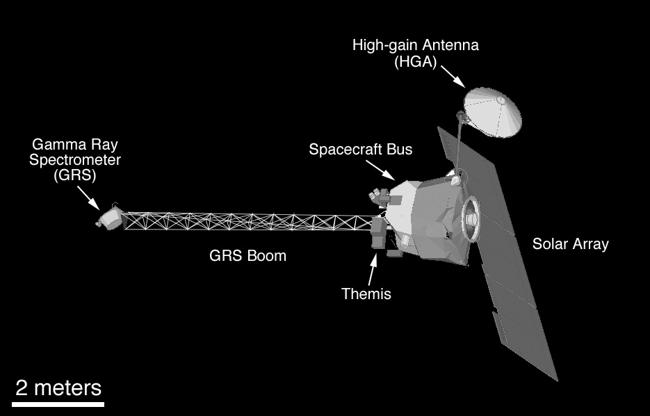